Siltcoos River

Last updated
Siltcoos River
Siltcoos River below dam.JPG
The river just below the dam near Siltcoos Lake
Name origin:A local Native American chief and family, it is said. [1]
Country United States
State Oregon
County Douglas and Lane
Source Siltcoos Lake
 - locationnear Westlake
 - elevation12 ft (4 m) [2]
 - coordinates 43°52′53″N124°06′45″W / 43.88139°N 124.11250°W / 43.88139; -124.11250   [3]
Mouth Pacific Ocean
 - elevation10 ft (3 m) [3]
 - coordinates 43°52′25″N124°09′14″W / 43.87361°N 124.15389°W / 43.87361; -124.15389 Coordinates: 43°52′25″N124°09′14″W / 43.87361°N 124.15389°W / 43.87361; -124.15389   [3]
USA Oregon location map.svg
Red pog.svg
Location of the mouth of the Siltcoos River in Oregon
Wikimedia Commons: Siltcoos River

The Siltcoos River is a 3-mile (4.8 km) stream on the central coast of the U.S. state of Oregon. It begins at Siltcoos Lake, which straddles the border between Douglas and Lane counties. The river meanders generally west to the Pacific Ocean. It is located about 8 miles (13 km) south of Florence and 13 miles (21 km) north of Reedsport. [4] The river, losing little elevation between source and mouth, [3] passes through the Westlake section of Dunes City, under U.S. Route 101, and through a marshy area and sand dunes of Oregon Dunes National Recreation Area, which is within Siuslaw National Forest. [4]

Oregon State of the United States of America

Oregon is a state in the Pacific Northwest region on the West Coast of the United States. The Columbia River delineates much of Oregon's northern boundary with Washington, while the Snake River delineates much of its eastern boundary with Idaho. The parallel 42° north delineates the southern boundary with California and Nevada. Oregon is one of only three states of the contiguous United States to have a coastline on the Pacific Ocean.

Siltcoos Lake lake of the United States of America

Siltcoos Lake (silt’-koos), at 3,164 acres (1,280 ha), is the largest lake on the Oregon Coast of the United States. Fed by runoff from a basin of about 68 square miles (180 km2) in Douglas and Lane counties, it is about 7 miles (11 km) south of Florence and 0.5 miles (1 km) east of U.S. Route 101. Its name comes from a Lower Umpqua (Siuslaw) placename, a variant of which is Tsiltcoos.

Douglas County, Oregon county in Oregon, USA

Douglas County is a county in the U.S. state of Oregon. As of the 2010 census, the population was 107,667. The county seat is Roseburg. It is named after Stephen A. Douglas, an American politician who supported Oregon statehood.

Contents

Recreation

The river's relative flatness makes it suitable for canoeing in either direction, although the lower end has no boat launch and the beach nearby is closed between March 15 and September 15 to protect snowy plover nesting areas. [5] Campgrounds along or near the river include Tyee, on the east side of U.S. Route 101, as well as Waxmyrtle, Lagoon, and Driftwood on the west side. [5] Tyee and the Lodgepole picnic area near the lake have canoe launch points; a small dam just west of Route 101 requires a portage. [5]

Snowy plover species of bird

The snowy plover is a small wader in the plover bird family. It breeds in Ecuador, Peru, Chile, the southern and western United States and the Caribbean. Long considered to be a subspecies of the Kentish plover, it is now known to be a distinct species.

Portage carrying water craft or cargo over land

Portage or portaging is the practice of carrying water craft or cargo over land, either around an obstacle in a river, or between two bodies of water. A path where items are regularly carried between bodies of water is also called a portage.

Trails wind through areas near the river. A 0.7-mile (1.1 km) self-guided nature trail follows an oxbow bend in the river near Lagoon campground. [6] A 1.3-mile (2.1 km) trail meanders along the river from Waxmyrtle campground to the beach, and a 4.3-mile (6.9 km) loop trail connects primitive campgrounds near Siltcoos Lake. [6] The Siltcoos Lake Trail, with a trailhead east of U.S. Route 101 about 7 miles (11 km) south of Florence, is frequented by mountain bikers. [5] [7]

Mountain biking bicycling sport

Mountain biking is a sport of riding bicycles off-road, often over rough terrain, using specially designed mountain bikes. Mountain bikes share similarities with other bikes but incorporate features designed to enhance durability and performance in rough terrain. Mountain biking can generally be broken down into multiple categories: cross country, trail riding, all mountain, downhill, freeride and dirt jumping. However, the majority of mountain biking falls into the categories of Trail and Cross Country riding styles.

Fishing for coho salmon, coastal cutthroat trout, and largemouth bass is allowed in the upstream stretch of the river between the lake and U.S. Route 101. Anglers fish from stream banks or from boats. There is a public boat ramp north of Westlake. [8]

Coho salmon species of fish

The coho salmon is a species of anadromous fish in the salmon family, one of the several species of Pacific salmon. Coho salmon are also known as silver salmon or "silvers". The scientific species name is based on the Russian common name kizhuch (кижуч).

Coastal cutthroat trout subspecies of fish

The coastal cutthroat trout also known as the sea-run cutthroat trout, or harvest trout is one of the several subspecies of cutthroat trout found in Western North America. The coastal cutthroat trout occurs in four distinct forms. A semi-anadromous or sea-run form is the most well known. Freshwater forms occur in both large and small rivers and streams and lake environments. The native range of the coastal cutthroat trout extends south from the southern coastline of the Kenai Peninsula in Alaska to the Eel River in Northern California. Coastal cutthroat trout are resident in tributary streams and rivers of the Pacific basin and are rarely found more than 100 miles (160 km) from the ocean.

Largemouth bass species of fish

The largemouth bass is a carnivorous freshwater gamefish in the Centrarchidae (sunfish) family, a species of black bass native to much of the United States And Northern Mexico. It is known by a variety of regional names, such as the widemouth bass, bigmouth bass, black bass, bucketmouth, largies, Potter's fish, Florida bass, Florida largemouth, green bass, Green trout, gilsdorf bass, Oswego bass, southern largemouth and (paradoxically) northern largemouth, LMB. The largemouth bass is the state fish of Georgia, Mississippi, and Indiana, the state freshwater fish of Florida and Alabama, and the state sport fish of Tennessee.

See also

Related Research Articles

Oregon Coast Trail

The Oregon Coast Trail (OCT) is a long-distance hiking route along the Pacific coast of Oregon in the United States. It follows the coast of Oregon from the mouth of the Columbia River to the California border south of Brookings.

Curecanti National Recreation Area

Curecanti National Recreation Area is a National Park Service unit located on the Gunnison River in western Colorado. Established in 1965, Curecanti is responsible for developing and managing recreational facilities on three reservoirs, Blue Mesa Reservoir, Morrow Point Reservoir and Crystal Reservoir, constructed on the upper Gunnison River in the 1960s by the U.S. Bureau of Reclamation to better utilize the vital waters of the Colorado River and its major tributaries. A popular destination for boating and fishing, Curecanti offers visitors two marinas, traditional and group campgrounds, hiking trails, boat launches, and boat-in campsites. The state's premiere lake trout and Kokanee salmon fisheries, Curecanti is a popular destination for boating and fishing, and is also a popular area for ice-fishing in the winter months.

Salmon River (Clackamas County, Oregon) river in Oregons Cascade Range

The Salmon River is a 33.5-mile (53.9 km) river in the Cascade Range in the U.S. state of Oregon that drains part of southwestern Mount Hood. The entire length of the river is a protected National Wild and Scenic River. Several portions are in protected wilderness. It is affluent to the Sandy River, a tributary of the Columbia River.

New River (Oregon) river in Oregon, U.S.

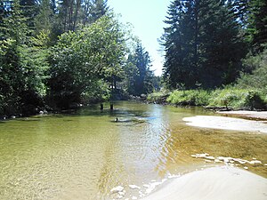
The New River is a stream, about 8 miles (13 km) long, on the southern coast of the U.S. state of Oregon. It begins slightly north of Floras Lake, at the confluence of the lake outlet and Floras Creek, and runs north behind a foredune until entering the Pacific Ocean between Bandon and Port Orford.

Trillium Lake

Trillium Lake is a lake situated 7.5 miles (12.1 km) south-southwest of Mount Hood in the U.S. state of Oregon. It is formed by a dam at the headwaters of Mud Creek, tributary to the Salmon River. It was created by the state Department of Fish and Wildlife in 1960.

Crooked River (Oregon) tributary of the Deschutes River in the U.S. state of Oregon

The Crooked River is a tributary, 125 miles (201 km) long, of the Deschutes River in the U.S. state of Oregon. The river begins at the confluence of the South Fork Crooked River and Beaver Creek. Of the two tributaries, the South Fork Crooked River is the larger and is sometimes considered part of the Crooked River proper. A variant name of the South Fork Crooked River is simply "Crooked River". The Deschutes River flows north into the Columbia River.

Applegate Lake

Applegate Lake is a 988-acre (400 ha) reservoir located in the Rogue River–Siskiyou National Forest about 27 miles (43 km) southwest of Medford in the U.S. state of Oregon. It is 16 miles (26 km) south of Oregon Route 238 along Applegate River Road and slightly north of the Oregon–California border. The lake is an impoundment of the Applegate River about 46 miles (74 km) from its confluence with the Rogue River.

Little Lava Lake lake of the United States of America

Little Lava Lake lies in the Cascade Range about 26 miles (42 km) west-southwest of Bend in the U.S. state of Oregon. A close neighbor of Lava Lake, from which it is separated by solidified lava, Little Lava Lake is at an elevation of 4,744 feet (1,446 m) in the Deschutes National Forest. Generally considered the source of the Deschutes River, the lake covers 138 acres (56 ha) to an average depth of 8 feet (2.4 m).

Deam Lake State Recreation Area

Deam Lake State Recreation Area is an Indiana State Recreation Area in Clark County, Indiana in the United States. The park is 1,300 acres (530 ha) and sits at an elevation of 535 feet (163 m). Deam Lake State Recreation area is open for year-round recreation, however the campground closes each year from the Sunday before Thanksgiving to March 1 of the following year. Much of the recreation is centered on Deam Lake. It is named for Charles C. Deam, the first state forester of Indiana.

Blue River Reservoir

Blue River Reservoir is an artificial impoundment, about 6 miles (10 km) long, of the Blue River in Lane County in the U.S. state of Oregon. The reservoir is about 1 mile (1.6 km) north of Oregon Route 126 in the Willamette National Forest about 45 miles (72 km) east of Eugene.

Woahink Lake lake of the United States of America

Woahink Lake extends further below sea level than any other lake dammed by sand dunes along the coast of the U.S. state of Oregon. The lake fills a depression in the Siltcoos River watershed about 3 miles (5 km) from the Pacific Ocean south of Florence along U.S. Route 101. The lowest point of the lake, which is up to 74 feet (23 m) deep, is about 36 feet (11 m) below sea level. The lake drains south to Siltcoos Lake via Woahink Creek. The lake's name may derive from the Siuslaw language.

Cleawox Lake lake in United States of America

Cleawox Lake, is a body of water dammed by sand dunes along the Pacific Ocean coast of the U.S. state of Oregon. The lake is about 3 miles (5 km) south of Florence along U.S. Route 101. Sharing the lakeshore are private properties as well as Oregon Dunes National Recreation Area and Jessie M. Honeyman Memorial State Park, which also partly fronts on Woahink Lake. Cleawox is derived from the Siuslaw name for the lake.

Tenmile Lake (Oregon) lake in Coos County, Oregon, USA

Tenmile Lake is the largest and southernmost of a chain of lakes along the Oregon Coast south of the Umpqua River in the United States. The chain includes North Tenmile, Eel, Clear, and smaller lakes, which drain into the Pacific Ocean via Tenmile Creek. The lake is 8 miles (13 km) south of Reedsport and 0.5 miles (0.80 km) east of U.S. Route 101 near the community of Lakeside.

North Tenmile Lake lake of the United States of America

North Tenmile Lake is one of a chain of lakes along the Oregon Coast south of the Umpqua River in the United States. The chain includes Tenmile, Eel, Clear, and smaller lakes, which drain into the Pacific Ocean via Tenmile Creek. The lake is 8 miles (13 km) south of Reedsport and 1 mile (1.6 km) east of U.S. Route 101 near the community of Lakeside. North Tenmile Lake is connected to Tenmile Lake by a navigable 0.5-mile (0.80 km) channel.

Tenmile Creek (Coos County, Oregon)

Tenmile Creek is the outlet for a chain of lakes ending at Tenmile Lake near Lakeside in Coos County in the U.S. state of Oregon. The creek flows generally west for about 3 miles (5 km) from the lake to the Pacific Ocean. The stream's name stems from its approximate distance from Winchester Bay, the earliest pioneer village along this part of the coast.

Hills Creek Reservoir

Hills Creek Reservoir, also known as Hills Creek Lake, is an artificial impoundment behind Hills Creek Dam on the Middle Fork Willamette River in the U.S. state of Oregon. The lake is near Oakridge in Lane County about 40 miles (64 km) southeast of Eugene, at the confluence of Hills Creek with the Middle Fork. The reservoir and its watershed lie within the Willamette National Forest.

Floras Lake lake of the United States of America

Floras Lake is a natural 236-acre (96 ha) body of water on the southern Oregon Coast of the United States. Fed by four small tributaries from a basin of about 10 square miles (26 km2) in Curry County, it lies about 10 miles (16 km) north of Port Orford and 2 miles (3 km) west of U.S. Route 101. It was probably named for Fred Flora, a 19th-century settler and miner who lived nearby.

Fall Creek (Middle Fork Willamette River)

Fall Creek is a 34-mile (55 km) tributary of the Middle Fork Willamette River in Lane County in the U.S. state of Oregon. Beginning in the Cascade Range, the creek flows generally west through the Willamette National Forest to enter the Middle Fork upstream of Jasper, southeast of Springfield and Eugene.

Tahkenitch Lake lake of the United States of America

Tahkenitch Lake, at 2,118 acres (857 ha), is one of the larger lakes along the coast of the U.S. state of Oregon. Fed by runoff from a basin of about 34 square miles (88 km2), it lies east of U.S. Route 101 in Douglas County between Florence and Reedsport. Its name comes from a Lower Umpqua (Siuslaw) placename meaning "having arms running out like a crab".

References

  1. McArthur, Lewis A.; McArthur, Lewis L. (2003) [1928]. Oregon Geographic Names (7th ed.). Portland: Oregon Historical Society Press. p. 876. ISBN   0-87595-277-1.
  2. Source elevation derived from Google Earth search using GNIS source coordinates.
  3. 1 2 3 4 "Siltcoos River". Geographic Names Information System. United States Geological Survey. November 28, 1980. Retrieved April 16, 2012.
  4. 1 2 Oregon Atlas & Gazetteer. Freeport, Maine: DeLorme Mapping. 1991. p. 32. ISBN   0-89933-235-8.
  5. 1 2 3 4 Richard, Terry (May 20, 2008). "Siltcoos River: Bring a Canoe and a Tent". The Oregonian. Portland, Oregon: Oregon Live, LLC. Retrieved April 16, 2012.
  6. 1 2 Sullivan, William (2009). Atlas of Oregon Wilderness. Eugene, Oregon: Navillus Press. p. 209. ISBN   978-0-9815701-2-9.
  7. "Siltcoos Lake Trailhead". U.S. Forest Service. Retrieved April 17, 2012.
  8. Sheehan, Madelynne Diness (2005). Fishing in Oregon: the Complete Oregon Fishing Guide (10th ed.). Scappoose, Oregon: Flying Pencil Publications. p. 37. ISBN   0-916473-15-5.