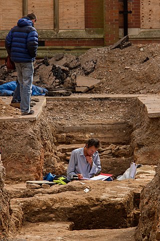
In archaeology, excavation is the exposure, processing and recording of archaeological remains. An excavation site or "dig" is the area being studied. These locations range from one to several areas at a time during a project and can be conducted over a few weeks to several years.
An artifact or artefact is a general term for an item made or given shape by humans, such as a tool or a work of art, especially an object of archaeological interest. In archaeology, the word has become a term of particular nuance; it is defined as an object recovered by archaeological endeavor, including cultural artifacts.

In archaeological excavation, a feature is a collection of one or more contexts representing some human non-portable activity, such as a hearth or wall. Features serve as an indication that the area in which they are found has been interfered with in the past, usually by humans.

In archaeology a section is a view in part of the archaeological sequence showing it in the vertical plane, as a cross section, and thereby illustrating its profile and stratigraphy. This may make it easier to view and interpret as it developed over time.
Urban archaeology is a sub discipline of archaeology specializing in the material past of towns and cities where long-term human habitation has often left a rich record of the past. In modern times, when someone talks about living in a city, they are in an area with many surrounding people and buildings, generally quite tall ones. In archaeological terms, cities give great information because of the infrastructure they have and amounts of people that were around one another. Through the years there has been one big method used for urban archaeology along with significant historic developments.

Stratigraphy is a key concept to modern archaeological theory and practice. Modern excavation techniques are based on stratigraphic principles. The concept derives from the geological use of the idea that sedimentation takes place according to uniform principles. When archaeological finds are below the surface of the ground, the identification of the context of each find is vital in enabling the archaeologist to draw conclusions about the site and about the nature and date of its occupation. It is the archaeologist's role to attempt to discover what contexts exist and how they came to be created. Archaeological stratification or sequence is the dynamic superimposition of single units of stratigraphy, or contexts.

The Harris matrix is a tool used to depict the temporal succession of archaeological contexts and thus the sequence of depositions and surfaces on a 'dry land' archaeological site, otherwise called a 'stratigraphic sequence'. The matrix reflects the relative position and stratigraphic contacts of observable stratigraphic units, or contexts. It was developed in 1973 in Winchester, England, by Edward C. Harris.

In archaeological excavation, a plan is a drawn record of features and artifacts in the horizontal plane.
The following outline is provided as an overview of and topical guide to archaeology:
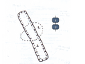
In archaeology, seriation is a relative dating method in which assemblages or artifacts from numerous sites in the same culture are placed in chronological order. Where absolute dating methods, such as radio carbon, cannot be applied, archaeologists have to use relative dating methods to date archaeological finds and features. Seriation is a standard method of dating in archaeology. It can be used to date stone tools, pottery fragments, and other artifacts. In Europe, it has been used frequently to reconstruct the chronological sequence of graves in a cemetery.

Reverse stratigraphy is the result of a process whereby one sediment is unearthed by human or natural actions and moved elsewhere, whereby the latest material will be deposited on the bottom of the new sediment, and progressively earlier material will be deposited higher and higher in the stratigraphy. Such events can be triggered by rockslides, tree throws, or other events which cause the strata of a deposit to be flipped or reversed. In archeological excavations a common cause of inversions in the stratigraphy is the collapse of walls on river banks or other raised mounds where deposits which have been cut through behind the wall prior to collapse slip over the collapsed structure resulting in the structure being under the deposits that originated earlier in time. In this case care must be taken to re-context the slipped deposits so the event of slippage appears in the correct place stratigraphically in the Harris matrix. There are numerous process that can reverse the stratigraphy or more accurately redeposit it. Many rely on slope processes, however other instances where deposits containing material later than overlying deposits occur in such features as drains or hypocaust systems. In these instances a clear understanding of the direction of "UP" and site formation processes is essential. Drains or hypocaust systems often have later material deposited within them during their "use", which may be much much later than either their initial construction or indeed the construction, use and disuse of the floors above them. Other human intervention, such as altering the ground level for architectural purposes by way of filling, can lead to an inversion of the stratigraphic layers.

The Wheeler–Kenyon method is a method of archaeological excavation. The technique originates from the work of Mortimer Wheeler and Tessa Wheeler at Verulamium (1930–35), and was later refined by Kathleen Kenyon during her excavations at Jericho (1952–58). The Wheeler–Kenyon system involves digging within a series of squares that can vary in size set within a larger grid. This leaves a freestanding wall of earth—known as a "balk"—that can range from 50 cm for temporary grids, and measure up to 2 metres in width for a deeper square. The normal width of a permanent balk is 1 metre on each side of a unit. These vertical slices of earth allow archaeologists to compare the exact provenance of a found object or feature to adjacent layers of earth ("strata"). During Kenyon's excavations at Jericho, this technique helped discern the long and complicated occupational history of the site. It was believed that this approach allowed more precise stratigraphic observations than earlier "horizontal exposure" techniques that relied on architectural and ceramic analysis.

In archaeology, a phase refers to the logical reduction of contexts recorded during excavation to nearly contemporary archaeological horizons that represent a distinct "phase" of previous land use. These often but not always will be a representation of a former land surface or occupation level and all associated features that were created into or from this point in time. A simplified description of phase would be that "a phase is a view of a given archaeological site as it would have been at time X".
In archaeology and archaeological stratification, a cut or truncation is a context that represents a moment in time when other archaeological deposits were removed for the creation of some feature, such as a ditch or pit. In layman's terms, a cut can be thought of as a hole that was dug in the past, though cut also applies to other parts of the archaeological record such as horizontal truncations like terraced ground. A cut context is sometimes referred to as a "negative context", as opposed to a "positive context". The term denotes that a cut has removed material from the archaeological record or natural at the time of its creation, as opposed to a positive context, which adds material to the archaeological record. A cut has zero thickness and no material properties of its own and is defined by the limits of other contexts. Cuts are seen in the record by virtue of the difference between the material it was cut through and the material that back-fills it. This difference is seen as an "edge" by the archaeologists on site. This is shown in the picture, where a half sectioned Saxon pit has had half its backfill removed and we can clearly see a difference between the ground the pit was cut into, and the material originally filling the pit. Sometimes these differences are not clear and an archaeologist must rely on experience and insight to discover cuts.

An archaeological relationship is the position in space and by implication, in time, of an object or context with respect to another. This is determined, not by linear measurement but by determining the sequence of their deposition – which arrived before the other. The key to this is stratigraphy.
In archaeology a fill is the material that has accumulated or has been deposited into a cut feature such as ditch or pit of some kind of a later date than the feature itself. Fills are an important part of the archaeological record as their formation and composition can throw light on many aspects of archaeological study.
Sequence dating, an archaeological relative dating method, allows assemblages to be arranged in a rough serial order, which is then taken to indicate time. Sequence dating is a method of seriation developed by the Egyptologist Sir William Matthew Flinders Petrie. By linking styles of pottery with different time periods, he was able to establish the relative chronology of the site.
In the field of archaeology, a spit is a unit of archaeological excavation with an arbitrarily assigned measurement of depth and extent. It is a method of excavation employed without regard to the archaeological stratigraphy that may be identifiable at the archaeological site under investigation. The method of excavating in arbitrary spits is most frequently encountered at site excavations which lack any visible or reconstructable stratigraphy in the archaeological context, or when excavating through intrusive or fill deposits.
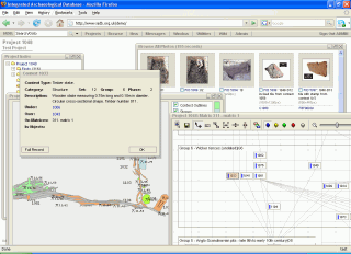
The Integrated Archaeological Database system, or IADB, is an open-source web-based application designed to address the data management requirements throughout the lifespan of archaeological excavation projects, from initial excavation recording, through post-excavation analysis and research to eventual dissemination and archiving.
This page is a glossary of archaeology, the study of the human past from material remains.