
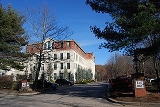
Wakefield is a village in the town of South Kingstown, Rhode Island, and the commercial center of the town. Together with the village of Peace Dale, it is treated by the U.S. Census as a component of the census-designated place identified as Wakefield-Peacedale, Rhode Island. West Kingston, another South Kingstown village, was the traditional county seat of Washington County. Since 1991, the Washington County Courthouse has been in Wakefield. The Sheriff's Office which handles corrections is also in Wakefield.
Georgiaville is a village in Smithfield, Providence County, Rhode Island, United States. The village was named after the Georgia Cotton Manufacturing Company mill located in the area. The Georgiaville Pond Beach is located in the village and is a popular recreation spot. In the 1920s the Ku Klux Klan was active in the area, and Klan rallies were held in Georgiaville. The village, which has retained many features of its origin as a mid-19th century mill village including the mill complex and several blocks of mill worker housing, was added to the National Register of Historic Places in 1985. Georgiaville is also where Smithfield's town hall is located.
Oakland is a village in Burrillville, Providence County, Rhode Island, United States. It was developed in the 19th century at the site of a stone mill near the confluence of the Chepachet and Clear Rivers. It is one of the few remaining stone mills in this state. Most of the village is included in the Oakland Historic District, a historic district listed on the National Register of Historic Places. Most of the housing in the village was originally built to house mill workers, although there are several more elaborate houses built for mill executives.

The Jamestown Windmill is a smock mill in Jamestown, Rhode Island within the Windmill Hill Historic District on North Road north of Weeden Lane.

Allenville Mill Storehouse is a historic mill storehouse at 5 Esmond Street in Esmond, Rhode Island within the town of Smithfield, Rhode Island. The exact date of construction is unknown, but it was built with rubble masonry construction which was typical of mill construction during and after the War of 1812. In 1813, Phillip Allen purchased 4.5 acres of land and constructed a mill on the site, but the first record to specifically refer to the storehouse was an insurance policy from 1836. Allen sold the property in 1857 and it changed ownership several times before it became Esmond Mills in 1906. In 1937, the building was used as a post office and described erroneously as the "Old Allenville Mill". The building has had some alterations to the front door and possibly the addition of a side door, but the interior of the structure was not detailed in the National Register of Historic Places nomination. The Allenville Mill Storehouse was added to the National Register of Historic Places in 1972.

Arnold Mills Historic District is a historic district encompassing a modest 19th-century mill village in eastern Cumberland, Rhode Island. The district lies along the Nate Whipple Highway and Sneech Pond Road, south of the Arnold Mills Reservoir. Sneech Pond Road was formerly the major east-west highway through the area prior to the construction of the Nate Whipple Highway in the 1960s. The Arnold Mills village is in part bisected by Abbott Run, the stream which serves as the outlet of the reservoir; Sneech Pond Road crosses the run on an early 20th-century steel Pratt pony truss, now closed to vehicular traffic. The houses along this road generally date from the late 18th to mid-19th century, and mainly reflect Federal and Greek Revival styling. The most prominent structure in the district is the Arnold Mills United Methodist Church, located at the western end of the district on Nate Whipple Highway; it was built 1825-27 and remodeled in 1846.
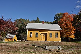
Clayville Historic District is an 81-acre (33 ha) historic district in Foster and Scituate, Rhode Island. The district encompasses the heart of the village of Clayville, a small 19th-century mill village. It is centered on the junction of Plainfield Pike, Field Hill Road, and Victory Highway near the Clayville Mill pond, and is roughly bisected by the town line between Foster and Scituate. The mill pond is impounded by a c. 1847 dam, which powered mills whose ruins and waterways lie downstream. The village is mainly residential, with vernacular 19th-century construction predominating. Notable buildings include the Clayville Christian Union Church, built 1867-71 with Greek Revival styling, and the c. 1845 Clayville Schoolhouse.

The Furnace Hill Brook Historic and Archeological District in a historic district in Cranston, Rhode Island.

The Wanskuck Historic District is a historic district in the city of Providence, Rhode Island encompassing a mill village with more than two hundred years of history. As early as the mid-18th century, mills stood on the West River in northern Providence, a development which continued with the rise of industrialization in the 19th century. The mill village of Wanskuck is organized around three thoroughfares: Branch Street, Veazie Street, and Woodward Road, and is roughly bounded on the east by Louisquisset Pike and to the northwest by the city line with North Providence. The West River runs through the district, with its banks lined by two late-19th-century mill complexes. The village area includes a variety of examples of mill worker housing, from duplexes to rowhouses, as well as two church complexes and a community hall built in 1884 by the Wanskuck Company.

The Davisville Historic District is a historic district on Davisville Road in Davisville, Rhode Island, a village in North Kingstown. It encompasses the site of an early 19th-century mill, and several associated buildings, including five houses dating to the 18th or 19th century and a cemetery. It is located on either side of Davisville Road, between the Hunt River and Olde Mill Lane.

The District Schoolhouse No. 2 is an historic school building on Old Post Road in the Cross Mills section of Charlestown, Rhode Island. The single-story Greek Revival structure was built c. 1838, and originally stood in the Quonochontaug area, before being moved to its present location in 1973. The schoolhouse is the best-preserved of Charlestown's eight 19th-century schoolhouses, and is now maintained by the Charlestown Historical Society.

The Fisherville Historic and Archeological District is a historic site in Exeter, Rhode Island. It is centered on Fisherville Brook in northeastern Exeter, around a mill complex that flourished in the mid-19th century. It includes the foundational remnants of a gristmill, sawmill, and included an abandoned early-19th century Cape style house at the time of its National Register nomination in 1980.
Hallville Historic and Archaeological District is a historic district in Exeter, Rhode Island.

Hillsdale Historic and Archeological District is a historic district in Richmond, Rhode Island. The district was added to the National Register of Historic Places in 1980. It represents the site of the former textile mill village of Hillsdale.

The Hope Village Historic District encompasses a historic mill village located in Scituate, Rhode Island. Located on a bend in the Pawtuxet River in southeastern Scituate, the area has seen industrial activity since the 18th century, and has surviving industrial and residential buildings from the early 19th century. The village is centered on the junction of Main Street and North Road, and radiates out from there, with numerous properties on smaller side streets. The present main mill building was built in 1844 by Brown & Ives, operators of numerous Rhode Island textile mills. Approximately 1/4 of the village's housing stock originated as mill worker housing built by the company.

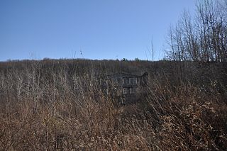
Lawton's Mill is a historic mill located on Ten Rod Road in Exeter, Rhode Island. The mill property includes an 18th-century house, an early 19th-century wood-frame mill building, and a 19th-century barn with early 20th-century additions. Also surviving from the period of the mill's activity are dams and waterways associated with it, including a dam and raceway extending several hundred feet north of the mill building. The mill building, which was built c. 1820, is one of a very small number of mill buildings to survive from the period in Rhode Island.
Parris Brook Historic and Archeological District is a historic district in Exeter, Rhode Island. The area includes remains of 18th- and 19th-century mill complexes, as well as prehistoric Native American rock shelters. It is mostly located in the Arcadia Management Area, a natural preserve managed by the state, and on adjacent private land.

The Shady Lea Historic District is a historic district on Shady Lea and Tower Hill Roads in North Kingstown, Rhode Island. It encompasses a predominantly residential linear district extending along Shady Lea Road southward from Tower Hill Road. Most of the houses along Shady Lea Road are mill worker housing built in the 19th century for workers at the mill complex which stands at the edge of the Shady Lea Mill Pond, at the southern end of the district. This area is a well-preserved example of the numerous rural mill complexes which dotted the Rhode Island countryside in the 19th century.

The South Main Street Historic District is a historic district in Coventry, Rhode Island. It extends along South Main Street from its crossing of the South Branch of the Pawtuxet River in the north, to just below Wood Street in the south, and includes a few properties on immediately adjacent streets. The area is almost entire residential, and was developed in the 19th century, providing housing for middle-class workers not directly affiliated with the mills that lined the river. About half the houses were built before 1850, and exhibit either Federal or Greek Revival styling, while most of the remaining houses were built before 1920. The principal non-residential structures are a VFW hall, which began as a mid-19th century residential structure associated with Rhode Island's prominent Whipple family, the Stillwater Company mill at the northern end of the district (1914), and the three-room Cady Street Schoolhouse (1844).

Blackstone River Valley National Historical Park is a National Park Service unit in the states of Rhode Island and Massachusetts. The park was created for the purpose of preserving, protecting, and interpreting the industrial heritage of the Blackstone River Valley and the urban, rural, and agricultural landscape of that region. The Blackstone River Valley was the site of some of the earliest successful textile mills in the United States, and these mills contributed significantly to the earliest American Industrial Revolution. The subsequent construction of the Blackstone Canal, a few years after the successful completion of the Erie Canal, helped to sustain the region's industrial strength.


