Temperate broadleaf and mixed forest is a temperate climate terrestrial habitat type defined by the World Wide Fund for Nature, with broadleaf tree ecoregions, and with conifer and broadleaf tree mixed coniferous forest ecoregions.

The Queensland tropical rain forests ecoregion covers a portion of the coast of Queensland in northeastern Australia and belongs to the Australasian realm. The forest contains the world's best living record of the major stages in the evolutionary history of the world's land plants, including most of the world's relict species of plants from the ancient supercontinent of Gondwana. The history of the evolution of marsupials and songbirds is also well represented.

The Changbai Mountains mixed forests ecoregion covers the Changbai Mountains and surrounding foothills in China and North Korea. The region features extensive and naturally preserved deciduous and conifer forests. The region exhibits high biodiversity due to its relative isolation, temperate climate with high rainfall, and centrality to central Chinese, Siberian, and European floral communities. In 1979, a significant portion of the ecoregion was designated the Changbaishan Biosphere Reserve by UNESCO.

The Hainan Island monsoon rain forests ecoregion covers mountainous interior of Hainan Island in China. The tropical forests receive over 1,000 mm/year of rain, heavily concentrated in the summer rainy season. The island has high levels of biodiversity, with over 4,200 plant species, 630 of which are endemic to the island. The region is under ecological pressure from deforestation for agriculture and timber extraction.

The Qin Ling Mountains deciduous forests ecoregion covers the Qin Mountains, which run west-to-east across central China. The mountains effectively divide the biological regions of China into north and south. To the north is the Yellow River basin, a loess-soil region of temperate deciduous forests. To the south is the Yangtze River basic, a subtropical forest region. In between, the Qin Mountains support many rare and endemic species, including the Giant panda and the Sichuan snub-nosed monkey.

The Jiang Nan subtropical evergreen forests ecoregion covers the mountainous divide between the lower Yangtze River and the coastal plain of South China. The region is also a climatic divide between the temperate valleys of the north and the subtropical forests of the south. The region is important for biodiversity and endemic species. The rugged limestone karst hills have been relatively protected from conversion to agriculture, and support specialized plant and animal communities.
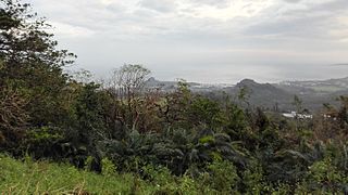
The South Taiwan monsoon rain forests ecoregion covers the southern tip of Taiwan, 200 km east of the mainland. The area is one of high biodiversity, due to its location between temperate and subtropical zones, its monsoon exposure, and its high altitude variation.

The Luang Prabang montane rain forests ecoregion covers elevations over 800 meters in the Luang Prabang mountains that straddle the border between northern Thailand and north-central Laos, and the highlands that stretch eastward across north-central Laos. While much of the forest cover has been degraded, there are still large areas of relatively untouched forest.

The Northern Annamites rain forests ecoregion covers the rugged and relatively unexplored northern Annamite Mountains of central Laos and Vietnam. There are high numbers of endemic plant species, and the relative remoteness and isolation of the area supports many rare and endangered animals. Rainfall is somewhat less than the lowland rainforest of the lower elevations in Vietnam, and the temperatures slightly cooler due to the higher elevation.

The Northern Vietnam lowland rain forests ecoregion covers the central-eastern coast of Vietnam from the Red River delta in the north to Tam Kỳ in the center of the country and neighboring adjacent parts of Laos. The region is one of the wet evergreen forests, with rain over 50 mm in every month. The forests have been highly degraded by human use, and the high levels of biodiversity have been pushed back into relatively small protected areas like Pu Mat National Park.
The Southern Annamites montane rain forests ecoregion covers a region of high biodiversity in the central and southern mountains of the Annamite Range in Vietnam. Terrain ranges from wet lowland forest to evergreen hardwood and conifer montane rain forest. There is a short dry season centered on January–February, but fog and dew are common throughout the year and support a lush forest character.

The Red River freshwater swamp forests ecoregion covers the freshwater portion of the Hong River delta in northern Vietnam. The ecoregion is separated from the sea by a thin coastal strip of the saltwater mangroves of the Indochina mangroves ecoregion. Very little of the little ecosystem remains; most of the delta has been converted to urbanization, industry, or agriculture. Less than 1% of the ecoregion is protected in significantly sized tracts.

The Southern Vietnam lowland dry forests ecoregion covers the low, relatively arid coastal strip of southern Vietnam on the South China Sea. The region is in the rain shadow of the Southern Annamite Range, which blocks humid air from the west. Although approximately half of the ecoregion is forested to some degree, most has at some point been cleared for agriculture or degraded by extraction of hardwoods. There are few protected areas.

The Northern Khorat Plateau moist deciduous forests ecoregion covers a small area on the border between northeastern Thailand and Laos, in the transition zone between the drier Khorat Plateau to the south and the wetter Annamite Range and Luang Prabang Range mountains to the north. Much of the ecoregion has been converted to agriculture along the floodplain of the middle course of the Mekong River.

The Northern Triangle subtropical forests ecoregion covers remote, mountainous terrain in the far north of Myanmar. Due to the regions isolation it is relatively untouched and unexplored by humans. Over 95% of the ecoregion is covered with closed evergreen forest, and importantly for conservation, these forests exist in large contiguous blocks. As of the late 1990s, 140 mammal species were known to be in the region, and new species, such the Leaf muntjac discovered in 1997, are still being found.

The Sulaiman Range alpine meadows ecoregion covers a series of higher altitude mountain ranges along the crest of the Sulaiman Mountains, a southerly extension of the Hindu Kush Mountains along the Afghanistan-Pakistan border. The area is relatively undeveloped, with about a third of the terrain either forested or in 'alpine steppe' shrub or herbaceous cover.

The Trinidad and Tobago moist forests ecoregion covers most of Trinidad Island and Tobago Island near the coast of South America where the southeastern Caribbean Sea meets the Atlantic Ocean. Small portions of the islands around river estuaries and coastal lowlands are mangroves or dry forests. Species diversity is very high, in particular for plants and birds. Tobago, being much smaller, has fewer species.

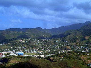
The Windward Islands moist forests ecoregion covers forested, high-precipitation areas of the volcanic Windward Islands. The forested areas are mostly at higher elevations in the interior of the islands, surrounded by dry forests, dry shrubland, or mangroves on the flat coastal lowlands. Closed forest of this ecoregion cover the majority of the islands. Species diversity is very high.
The Lesser Antillean dry forests ecoregion covers the dry forests of the coastal lowlands of the Lesser Antilles, where the eastern Caribbean Sea meets the Atlantic Ocean. These forests generally form a band around the interior wet forests of higher elevations, and because they are often flat, they are under the most pressure for human settlement and agriculture.

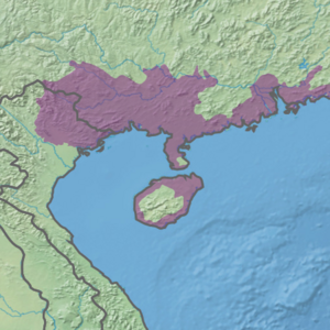
Samursky National Park is located on the west coast of the Caspian Sea, at the eastern extent of the Greater Caucasus Mountains in Dagestan, Russia. It is divided into two sectors: a coastal floodplain section on the delta of the Samur River, and a mountainous sector that includes Mount Bazardüzü and the southernmost extreme point in Russia. The coastal sector is notable for supporting a temperate-subtropical liana forest. The park also protects near-shore waters of the Caspian. The park was officially created in 2019.