South Malawi montane forest–grassland mosaic

Last updated
South Malawi montane forest-grassland mosaic
Widdringtonia whytei Mulanje Malawi.jpg
Mulanje cypress (Widdringtonia whytei) on Mount Mulanje
AT1014 map.png
Extent of the ecoregion in southern Malawi
Ecology
Realm Afrotropic
Biome Montane grasslands and shrublands
Geography
Area10,100 km2 (3,900 sq mi)
CountryMalawi
Conservation
Conservation status critical/endangered

The South Malawi montane forest-grassland mosaic is an ecoregion of Malawi.

Contents

The ecoregion covers a region of highlands and plateaus that includes Mount Mulanje (3,002 m) in the southeast and the lower Shire Highlands to the northeast and east, with the Tuchila Plain between them. The Shire Highlands includes the Zomba Plateau (2,087 m) in the north and the Thyolo Mountains (1,462 m) to the south.

The low valley of the Shire River, part of the African Rift Valley system, bounds the Shire Highlands to the northwest, west, and southwest. The valley of the Ruo River, a tributary of the Shire, bounds the ecoregion on the south and southeast. The Phalombe Plain and the valley of Lake Chilwa lie to the northeast. [1]

The ecoregion enjoyed lush forests, fertile soils, ample water, and mild climate, and is one of the most densely populated regions of Malawi. Blantyre, Malawi's second-largest city, is in the Shire Highlands. Tea is grown commercially in the highlands, especially around Thyolo and Mulanje, and is one of Malawi's chief exports.

The highlands' climate and geology are home to communities of plants and animals distinct from the woodland and savanna ecoregions of the surrounding lowlands. The ecoregion is bounded to the southeast by the Eastern miombo woodlands, and to the northwest by the Southern miombo woodlands. The generally drier Zambezian and mopane woodlands lie to the southwest in the Zambezi lowlands, and to the east in the basin of Lake Chilwa.

Climate

The ecoregion has a tropical highlands climate, generally cooler and more humid than the surrounding lowlands. There is a single summer rainy season between November to April. Moisture-bearing winds from the southeast, known as Chiperone weather, provide occasional moisture during the dry season, producing mist and rain as they encounter the mountain slopes. Northern and western slopes are generally drier than the south and east-facing slopes. [1]

Frosts occur at the highest elevations in the Mulanje Massif.

Flora

The ecoregion has several distinct plant communities, which vary with elevation and exposure.

Until recently, rainforests were predominant on the southern and southeastern slopes of Mt. Mulanje, with the trees Newtonia buchananii and Khaya anthotheca predominant. Most have been cleared, but remnants exist in stream valleys.

Mid-elevation forests are found between 900 and 1,350 meters elevation. Newtonia buchananii , Albizia adianthifolia , Funtumia africana , and Gambeya gorungosana are the dominant trees in the low-canopy forest, and host many lichens, mosses and epiphytes.

Afromontane forests occur in fragmented patches above 1600 meters elevation, with Mulanje cedar ( Widdringtonia whytei ), Olea capensis , Podocarpus milanjianus , Ekebergia capensis , Cassipourea malosana, and Rapanea melanophloeos as the dominant trees. Mulanje cedar is endemic to the ecoregion, found only on Mulanje in valley forests protected from fire.

Other plant communities include tussock grasslands, and Afromontane heathlands on the highest elevations of Mulanje. [1]

Fauna

The region hosts a large variety of wildlife many of which cannot be found elsewhere. Birds like the Yellow-throated apalis and the Thyolo alethe (Chamaetylas choloensis) are either fully or partially endemic to the region.

Protected areas

Protected areas in the ecoregion include:

Related Research Articles

<span class="mw-page-title-main">Geography of Malawi</span> Geographical features of Malawi

Malawi is a landlocked country in southeast Africa. It is wholly within the tropics; from about 9°30S at its northernmost point to about 17°S at the southernmost tip. The country occupies a thin strip of land between Zambia and Mozambique, extending southwards into Mozambique along the valley of the Shire River. In the north and north east it also shares a border with Tanzania. Malawi is connected by rail to the Mozambican ports of Nacala and Beira. It lies between latitudes 9° and 18°S, and longitudes 32° and 36°E.

<span class="mw-page-title-main">Eastern Highlands</span> Mountain range in Zimbabwe and Mozambique

The Eastern Highlands, also known as the Manica Highlands, is a mountain range on the border of Zimbabwe and Mozambique. The Eastern Highlands extend north and south for about 300 kilometres (190 mi) through Zimbabwe's Manicaland Province and Mozambique's Manica Province.

<span class="mw-page-title-main">Shire Highlands</span> Plateau in southern Malawi

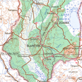
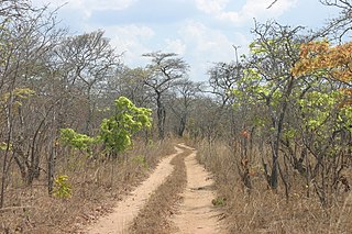
The Shire Highlands are a plateau in southern Malawi, located east of the Shire River. It is a major agricultural area and the most densely populated part of the country.

<span class="mw-page-title-main">Zomba Plateau</span> Mountain in southern Malawi

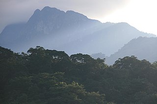
The Zomba Plateau, also called the Zomba Massif, is a mountain of the Shire Highlands in southern Malawi. Its total area is about 130 square kilometres (50 sq mi), with a highest point of 2,087 metres (6,847 ft).

<span class="mw-page-title-main">Udzungwa Mountains</span> Mountain range in south-central Tanzania

The Udzungwa Mountains are a mountain range in south-central Tanzania. The mountains are mostly within Iringa Region, south of Tanzania's capital Dodoma. The Udzungwa Mountains are part of the Eastern Arc Mountains, and are home to a biodiverse community of flora and fauna with large numbers of endemic species.

<span class="mw-page-title-main">Mount Rungwe</span>


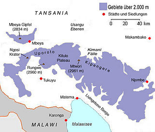
Mount Rungwe is a volcanic mountain in Mbeya Region, in Tanzania's Southern Highlands. At an altitude of 2,981 metres (9,780 ft), it is southern Tanzania's second-highest peak. Rungwe's volcano is currently inactive.

<span class="mw-page-title-main">Wildlife of Malawi</span>

The wildlife of Malawi is composed of the flora and fauna of the country. Malawi is a landlocked country in southeastern Africa, with Lake Malawi taking up about a third of the country's area. It has around 187 species of mammal, some 648 species of birds have been recorded in the country and around 500 species of fish, many of them endemic, are found in its lakes and rivers. About 20% of the country has been set aside as national parks and game and forest reserves.

<span class="mw-page-title-main">Southern Zanzibar–Inhambane coastal forest mosaic</span> Tropical moist broadleaf forest ecoregion of eastern Africa

The Southern Zanzibar-Inhambane coastal forest mosaic, also known as the Southern Swahili coastal forests and woodlands, is a tropical moist broadleaf forest ecoregion of eastern Africa. It is a southern variation of Northern Zanzibar-Inhambane coastal forest mosaic. The ecoregion supports habitats of forest, savanna and swamps. The southern portion of the ecoregion is not as well studied due to the 1977-1992 civil war in Mozambique.

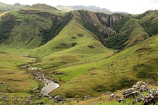
The Southern Highlands is a highland region in southwestern Tanzania, at the northern end of Lake Malawi. The highlands include portions of Mbeya, Njombe, Rukwa, Ruvuma, and Songwe regions, bordering Malawi, Mozambique, and Zambia. Mbeya is the largest city in the highlands.

<span class="mw-page-title-main">Eastern Arc forests</span>

The Eastern Arc forests is a montane tropical moist forest ecoregion of eastern Africa. The ecoregion comprises several separate highland areas above 800 meters in Kenya, and (mostly) Tanzania.

<span class="mw-page-title-main">Ethiopian montane forests</span>

The Ethiopian montane forests is a tropical moist broadleaf forest ecoregion in eastern Africa. It covers the middle elevations of the Ethiopian Highlands in Ethiopia and extends into neighboring Eritrea, Sudan, Djibouti, and Somaliland. The ecoregion includes distinctive Afromontane forests, woodlands, grasslands, and shrublands. The ecoregion's biodiversity is threatened by deforestation, conversion to agriculture, and overgrazing.

<span class="mw-page-title-main">Chimanimani Mountains</span> Mountain range in Mozambique and Zimbabwe

The Chimanimani Mountains are a mountain range on the border of Zimbabwe and Mozambique. The mountains are in the southern portion of the Eastern Highlands, or Manica Highlands, a belt of highlands that extend north and south along the international border, between the Zambezi and Save rivers.

<span class="mw-page-title-main">Mount Gorongosa</span>

Mount Gorongosa is an inselberg in Sofala Province of central Mozambique. Its highest peak, Gogogo, reaches an elevation of 1,863 meters. It was created by Karoo Volcanism.

Mount Chiperone is a mountain in northern Mozambique.

The Umalila Mountains are a mountain range in southern Tanzania, on the border with Malawi. The Umalila Mountains are part of Tanzania's Southern Highlands.

<span class="mw-page-title-main">Southern miombo woodlands</span>

The Southern miombo woodlands is a tropical grasslands and woodlands ecoregion extending across portions of Malawi, Mozambique, Zambia, and Zimbabwe.

The Nguu Mountains are a mountain range in Tanga Region of Tanzania. The Nguu Mountains are part of the Eastern Arc Mountains. The mountains are covered in woodland, grassland, and forest.

<span class="mw-page-title-main">Victoria Basin forest–savanna mosaic</span>

The Victoria Basin forest–grassland mosaic is an ecoregion that lies mostly in Uganda and extends into neighboring countries. The ecoregion is centered north and west of Lake Victoria, with an outlier on the border of Ethiopia and South Sudan.

The Njesi Highlands are a range of mountains in northern Mozambique.

References

  1. 1 2 3 "South Malawi montane forest-grassland mosaic". Terrestrial Ecoregions. World Wildlife Fund.