
Natural Bridge is a geological formation in Rockbridge County, Virginia, comprising a 215-foot-high (66 m) natural arch with a span of 90 feet (27 m). It is situated within a gorge carved from the surrounding mountainous limestone terrain by Cedar Creek, a small tributary of the James River. Consisting of horizontal limestone strata, Natural Bridge is the remains of the roof of a cave or tunnel through which the Cedar Creek once flowed.

This is a list of properties on the National Register of Historic Places in the U.S. state of Michigan.
The Nebraska Department of Transportation (NDOT) is the state government agency charged with building and maintaining the state and Federal highways in the U.S. State of Nebraska, as well as the state's airports. The main headquarters of the agency is located in Lincoln, the capital city. There are currently eight NDOT district offices located across the state.

The Plattsmouth Bridge is a truss bridge over the Missouri River connecting Cass County, Nebraska and Mills County, Iowa. Until 2014, it carried U.S. Highway 34 across the river.
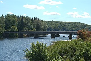
The Lisco State Aid Bridge is located on a county road over the North Platte River south of Lisco, Nebraska. Completed in 1928, the bridge today "is distinguished as an important crossing of the Platte River and one of the last two intact multiple-span state aid truss bridges" in Nebraska.

19th Street Bridge is a two-span through Pratt truss road bridge in Denver, Colorado, over the South Platte River, now used for pedestrians. It was built in 1888 to replace a wooden structure and carried automobile traffic until 1986. The bridge is listed on the National Register of Historic Places.
Trunk Line Bridge No. 1, also known as Peshekee River Bridge, is a bridge adjacent to US Highway 41/M-28 (US 41/M-28). It was the first of many trunkline bridges designed by the Michigan State Highway Department. It was built in 1914, and listed on the National Register of Historic Places in 1999.

The Kettle Falls Bridges is the collective name for a pair of steel cantilever bridges carrying State Route 20/U.S. Route 395 and the Kettle Falls International Railway across the Columbia River at Kettle Falls, Washington. The south bridge carries motor vehicle traffic while the similar northern span is used for rail.
The Cache River Bridge is a Parker pony truss that spans the Cache River between Walnut Ridge and Paragould, Arkansas. It was built in 1934 by the Arkansas State Highway Commission and was designed by the Vincennes Bridge Company. Formerly carrying U.S. Route 412 and earlier Arkansas Highway 25, the structure was added to the National Register of Historic Places in 1990, and was bypassed by a new bridge in 1995.

The US 2–Iron River Bridge is a bridge located on Genesee Street over the Iron River in Iron River, Michigan. It was listed on the National Register of Historic Places in 1999.

The North Watervliet Road–Paw Paw Lake Outlet Bridge, also known as Trunk Line Bridge No. 57, was an arch bridge in Watervliet Township, Michigan, that carried North Watervliet Road over the outlet of Paw Paw Lake into the Paw Paw River. It is listed on the National Register of Historic Places. The bridge was demolished and replaced about 2008.

The DML Butler Bridge is a Camelback through truss bridge located near Grand Encampment, Wyoming, which carries Carbon County Road CN6-203 across the North Platte River. Contractor Chris O'Neil built the bridge in 1920 to replace a wooden bridge built in 1905. The bridge is one of two Camelback truss bridges remaining on a Wyoming county highway and, at 170 feet (52 m) long, is the longer of the two.
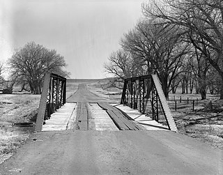
The EWZ Bridge over East Channel of Laramie River is a Pratt pony truss bridge located near Wheatland, Wyoming, which carries Platte County Road CN8-204 over the East Channel of the Laramie River. The bridge was built from 1913 to 1914 by the Pueblo Bridge Company. The single-span bridge is 71 feet 2 inches (21.69 m) long. The bridge's five-panel Pratt pony truss design with steel pin connections was used fairly frequently in Wyoming highway bridges, and the bridge is one of the older examples of the style.
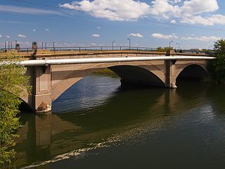
The Nymore Bridge is a reinforced concrete deck arch bridge spanning the Mississippi River in Bemidji, Minnesota. The bridge, built in 1916, has three arch spans. It is significant for its use of a reinforcing system patented by George M. Cheney during a time when engineers were experimenting with reinforcing materials and systems.

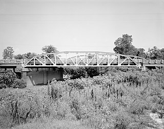
The Bloomfield-Nulhegan River Route 102 Bridge is a historic bridge in Bloomfield, Vermont. It carries Vermont Route 102 over the Nulhegan River, near its mouth at the Connecticut River just south of Bloomfield Village. Built in 1937, it is a well-preserved example of a Pratt through truss, exhibiting then state-of-the-art engineering. It was listed on the National Register of Historic Places in 1991.

The Newport Bridge is a historic cantilevered Warren truss bridge over the White River in Newport, Arkansas. Built in 1930 to carry U.S. Route 67 (US 67), the road it carries is now designated Arkansas Highway 367 (AR 367) after the former highway was relocated. The main bridge is 400 feet (120 m) long, with approaches from the west of 1,278 feet (390 m) and the south of 911 feet (278 m). It has cantilevered arms 138 feet (42 m) long supported by concrete piers, with a suspended Warren truss span of 125 feet (38 m). Designed by Ira G. Hedrick, it is one of three such bridges in the state.

The St. Alban's Bay Culvert is a historic bridge in Garrison Township, Minnesota, United States. It carries the four-lane U.S. Route 169 (US 169) over the head of a stream flowing out of Mille Lacs Lake. It was built from 1938 to 1939 as part of a major New Deal project to create a scenic parkway along the lakeshore. The bridge was listed on the National Register of Historic Places in 2015 as the St. Alban's Bay Culvert at Mille Lacs Lake for having state-level significance in the themes of architecture and politics/government. It was nominated for being a well-preserved example of the Minnesota Highway Department's earliest scenic improvements, its rare status as a highway bridge built by the department's Roadside Development Division—a unit usually focused on overlooks and waysides—and for its fine National Park Service rustic design.

The Allentown Bridge is a bridge spanning the Puerco River near Houck, Arizona, located in Apache County. The existing structure was completed in 1923 and is listed on the National Register of Historic Places.

The Garrison Concourse is a roadside park on Mille Lacs Lake in Garrison, Minnesota, United States. The site consists of a wide parking area and scenic overlook projecting out into the lake, plus landscaped parkland along the shore in both directions. It was built from 1936 to 1939 as the centerpiece of the Mille Lacs Highway Development Plan, a major New Deal project to create a scenic parkway along the lakeshore. The park was listed on the National Register of Historic Places in 2013 for having state-level significance in the themes of landscape architecture and politics/government. It was nominated for being the premiere structure of the most extensive roadside development project undertaken by the Minnesota Highway Department and the Civilian Conservation Corps, and for its blend of formalism and National Park Service rustic design.

The State Highway 34 Bridge at the Trinity River near Rosser, Texas was built in 1933-34. It brought State Highway 34 across the Trinity River, between Ellis County, Texas and Kaufman County, Texas.


