Sparone

Last updated
Sparone
Comune
Comune di Sparone

Sparone Rocca Re Arduino.JPG

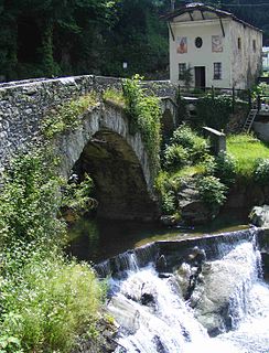
Castle (Rocca) of King Arduin of Ivrea.
Sparone-Stemma.png
Coat of arms
Italy provincial location map 2015.svg
Red pog.svg
Sparone
Location of Sparone in Italy
Coordinates: 45°25′N7°33′E / 45.417°N 7.550°E / 45.417; 7.550
Country Italy
Region Piedmont
Metropolitan city Turin (TO)
Government
  Mayor Anna Bonino
Area
  Total 29.5 km2 (11.4 sq mi)
Elevation 552 m (1,811 ft)
Population (31 December 2012) [1]
  Total 1,115
  Density 38/km2 (98/sq mi)
Demonym(s) Sparonesi
Time zone CET (UTC+1)
  Summer (DST) CEST (UTC+2)
Postal code10080
Dialing code 0124
Patron saint St. James the Apostle
Saint day 25 July
Website Official website

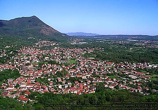
Sparone is a comune (municipality) in the Metropolitan City of Turin in the Italian region of Piedmont, located about 40 kilometres (25 mi) northwest of Turin in the Canavese.

<i>Comune</i> third-level administrative divisions of the Italian Republic

The comune is a basic administrative division in Italy, roughly equivalent to a township or municipality.

Metropolitan City of Turin Metropolitan City in Piedmont, Italy

The Metropolitan City of Turin is a metropolitan city in the Piedmont region, Italy. Its capital is the city of Turin. It replaced the Province of Turin and comprises the city of Turin and 315 other municipalities (comuni). It was first created by the reform of local authorities and then established by the Law 56/2014. It has been officially operative since 1 January 2015.

Italy republic in Southern Europe

Italy, officially the Italian Republic, is a country in Europe. Located in the middle of the Mediterranean Sea, Italy shares open land borders with France, Switzerland, Austria, Slovenia and the enclaved microstates San Marino and Vatican City. Italy covers an area of 301,340 km2 (116,350 sq mi) and has a largely temperate seasonal and Mediterranean climate. With around 61 million inhabitants, it is the fourth-most populous EU member state and the most populous country in Southern Europe.

It is home to the Romanesque church of Santa Croce, of medieval origin, which houses several Gothic frescoes.

Romanesque architecture architectural style of Medieval Europe

Romanesque architecture is an architectural style of medieval Europe characterized by semi-circular arches. There is no consensus for the beginning date of the Romanesque style, with proposals ranging from the 6th to the 11th century, this later date being the most commonly held. In the 12th century it developed into the Gothic style, marked by pointed arches. Examples of Romanesque architecture can be found across the continent, making it the first pan-European architectural style since Imperial Roman architecture. The Romanesque style in England is traditionally referred to as Norman architecture.

Gothic art Style of Medieval art developed in Northern France

Gothic art was a style of medieval art that developed in Northern France out of Romanesque art in the 12th century AD, led by the concurrent development of Gothic architecture. It spread to all of Western Europe, and much of Southern and Central Europe, never quite effacing more classical styles in Italy. In the late 14th century, the sophisticated court style of International Gothic developed, which continued to evolve until the late 15th century. In many areas, especially Germany, Late Gothic art continued well into the 16th century, before being subsumed into Renaissance art. Primary media in the Gothic period included sculpture, panel painting, stained glass, fresco and illuminated manuscripts. The easily recognizable shifts in architecture from Romanesque to Gothic, and Gothic to Renaissance styles, are typically used to define the periods in art in all media, although in many ways figurative art developed at a different pace.

The communal territory includes several frazioni: Aia di Pietra, Apparè, Barchero, Bisdonio, Bose, Budrer, Calsazio, Ceresetta, Costa, Feilongo, Frachiamo, Nosè, Onzino, Piani, Sommavilla, Torre, and Vasario. [2]

"Frazione" is the Italian name given in administrative law to a type of territorial subdivision of a comune; for other administrative divisions, see municipio, circoscrizione, quartiere. It is cognate to the English word fraction, but in practice is roughly equivalent to "parishes" or "wards" in other countries.

Related Research Articles

Moncalieri Comune in Piedmont, Italy

Moncalieri is a town and comune of 57,518 inhabitants about 8 kilometres (5 mi) directly south of downtown Turin, in Piedmont, Italy. It is notable for its castle, built in the 12th century and enlarged in the 15th century, which later became the favorite residence of Maria Clotilde and Victor Emmanuel II of Italy. It is part of the World Heritage Site Residences of the Royal House of Savoy.

Alpette Comune in Piedmont, Italy

Alpette is a comune (municipality) in the Metropolitan City of Turin in the Italian region Piedmont, located about 40 kilometres (25 mi) north of Turin.

Canischio Comune in Piedmont, Italy

Canischio is a comune (municipality) in the Metropolitan City of Turin in the Italian region Piedmont, located about 35 kilometres (22 mi) north of Turin.

Caprie Comune in Piedmont, Italy

Caprie is a comune (municipality) in the Metropolitan City of Turin in the Italian region Piedmont, about 35 kilometres (22 mi) west of Turin. Caprie borders the following municipalities: Condove, Rubiana, Villar Dora, Sant'Ambrogio di Torino, and Chiusa di San Michele.

Ceres, Piedmont Comune in Piedmont, Italy

Ceres is a comune (municipality) in the Metropolitan City of Turin in the Italian region Piedmont, located about 35 kilometres (22 mi) northwest of Turin.

Corio, Piedmont Comune in Piedmont, Italy

Corio is a comune (municipality) in the Metropolitan City of Turin in the Italian region of Piedmont, located about 30 kilometres (19 mi) northwest of Turin.

Ingria, Piedmont Comune in Piedmont, Italy

Ingria is a comune (municipality) in the Metropolitan City of Turin in the Italian region Piedmont, located about 45 kilometres (28 mi) north of Turin in the Valle Soana.

Locana Comune in Piedmont, Italy

Locana is a comune (municipality) in the Metropolitan City of Turin in the Italian region Piedmont, located about 45 kilometres (28 mi) northwest of Turin in the Orco Valley. In the early 1900s the town had about 7,000 residents. As of 2019 the population declined to 1,500.

Monastero di Lanzo Comune in Piedmont, Italy

Monastero di Lanzo is a comune (municipality) in the Metropolitan City of Turin in the Italian region Piedmont, located about 35 km northwest of Turin.

Pont-Canavese Comune in Piedmont, Italy

Pont Canavese is a comune (municipality) in the Metropolitan City of Turin in the Italian region Piedmont, located about 40 kilometres (25 mi) north of Turin. It occupies a small fluvial plain between the rivers Orco and Soana: its names derives from the series of bridges that were historically built here to cross those rivers.

Pratiglione Comune in Piedmont, Italy

Pratiglione is a comune (municipality) in the Metropolitan City of Turin in the Italian region Piedmont. It is located about 45 kilometres (28 mi) north of Turin, in the Canavese geographical area.

Ribordone Comune in Piedmont, Italy

Ribordone is a comune (municipality) in the Metropolitan City of Turin in the Italian region Piedmont, about 45 km northwest of Turin. At 31 December 2004 it had a population of 81 and an area of 44.2 km².

Ronco Canavese Comune in Piedmont, Italy

Ronco Canavese is a comune (municipality) in the Metropolitan City of Turin in the Italian region Piedmont, located about 50 kilometres (31 mi) north of Turin.

Rorà Comune in Piedmont, Italy

Rorà is a comune (municipality) in the Metropolitan City of Turin in the Italian region Piedmont, located about 50 km southwest of Turin

Rosta, Piedmont Comune in Piedmont, Italy

Rosta is a comune (municipality) in the Metropolitan City of Turin in the Italian region Piedmont, located about 20 kilometres (12 mi) west of Turin.

Salza di Pinerolo Comune in Piedmont, Italy

Salza di Pinerolo is a comune (municipality) in the Metropolitan City of Turin in the Italian region Piedmont, located about 50 kilometres (31 mi) southwest of Turin.

San Secondo di Pinerolo Comune in Piedmont, Italy

San Secondo di Pinerolo is a comune (municipality) in the Metropolitan City of Turin in the Italian region Piedmont, located about 40 kilometres (25 mi) southwest of Turin.

SantAntonino di Susa Comune in Piedmont, Italy

Sant'Antonino di Susa is a comune (municipality) in the Metropolitan City of Turin in the Italian region Piedmont, located in the Val di Susa about 35 kilometres (22 mi) west of Turin.

Villarbasse Comune in Piedmont, Italy

Villarbasse is a comune (municipality) in the Metropolitan City of Turin in the Italian region Piedmont, located about 20 kilometres (12 mi) west of Turin.

Villar Dora Comune in Piedmont, Italy

Villar Dora is a comune (municipality) in the Metropolitan City of Turin in the Italian region Piedmont, located about 25 km west of Turin.

References

  1. Demographic data from Istat
  2. ": Comune di Sparone : Il territorio" (in Italian). Comune di Sparone. Retrieved 8 July 2014.