
Tyne and Wear is a metropolitan county in North East England, situated around the mouths of the rivers Tyne and Wear. It came into existence in 1974 after the passage of the Local Government Act 1972. It consists of five metropolitan boroughs - Newcastle upon Tyne, Gateshead, North Tyneside, South Tyneside and the City of Sunderland. The county is bordered to the north by Northumberland, to the south by County Durham and to the east of the county lies the North Sea. It is the smallest county in North East England by area, but by far the largest in terms of population.

Gateshead is a large town in North East England and principal settlement of the Metropolitan Borough of Gateshead, situated on the southern bank of the River Tyne. It is connected to Newcastle upon Tyne by seven bridges. The town is known for its architecture, including The Sage, the Angel of the North and the Baltic Centre for Contemporary Art. In 2011, the population of Gateshead town was recorded as 120,046.

The Metropolitan Borough of Gateshead is a metropolitan borough in the metropolitan county of Tyne and Wear, North East England. It includes Gateshead, Rowlands Gill, Whickham, Blaydon, Ryton, Felling, Pelaw, Dunston and Low Fell. The borough forms part of the Tyneside conurbation, centred on Newcastle upon Tyne.
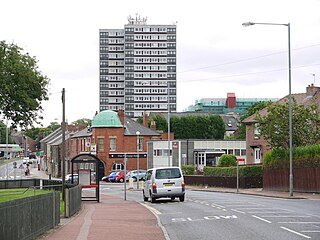
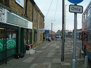
Felling is an eastern suburb of Gateshead, Tyne and Wear, England. The town was formed when three villages coalesced in the 19th century. Historically part of County Durham, the town was subsumed into the metropolitan borough of Gateshead in 1974. It lies on the B1426 Sunderland Road and the A184 Felling bypass, less than 1 mile (1.6 km) east of Gateshead town centre, 1 mile (1.6 km) south east of Newcastle-upon-Tyne and 10 miles north west of the City of Sunderland. In 2011, Felling had a population of 8,908.

Rowlands Gill is a town situated along the A694, between Winlaton Mill and Hamsterley Mill, on the north bank of the River Derwent, in the Metropolitan Borough of Gateshead, Tyne and Wear, England. Within Gateshead's greenbelt, the town has a picturesque setting with much open space and views across the valley to Gibside Estate, now owned by the National Trust.

Ryton is a town in the Metropolitan Borough of Gateshead, Tyne and Wear, England, 5.8 miles (9.3 km) west of Newcastle upon Tyne. Historically in County Durham, it was incorporated into the metropolitan county of Tyne and Wear and the Borough of Gateshead in 1974. In 2011, the population of the Ryton, Crookhill and Stella ward was 8,146.
Crawcrook is a semi-rural village close to the western border of the metropolitan county of Tyne and Wear in England. Traditionally an independent village in County Durham, it was incorporated into the Metropolitan Borough of Gateshead on 1 April 1974. The population taken at the 2011 Census of the Gateshead ward had increased to 8,841.

Team Valley is a trading estate located in Gateshead. It is home to the Retail World retail park, with many large, international companies are based in the area's trading estate. In 2017, there were approximately 700 companies on the estate, employing approximately 20,000 people.

Birtley is a town in the Metropolitan Borough of Gateshead, in Tyne and Wear, England. It is situated to the south of Gateshead and is physically linked to Chester-le-Street across the county boundary. Until 1974, Birtley and the adjoining areas of Barley Mow, Vigo and Portobello were part of the old Chester-le-Street Rural District in County Durham. Since 1974, these neighbouring areas have been considered part of 'greater' Birtley. Birtley was a civil parish with a parish council until 1 April 2006, after a local referendum agreed to abolish it. The former parish had a population of 11,377 in 2001. The ward of Birtley in the Gateshead MBC had a population of 8,367 in the 2011 Census.
Deckham is a residential suburb in the Metropolitan Borough of Gateshead in Tyne and Wear, England. It is bordered by Gateshead town centre to the north, Sheriff Hill to the south, Felling and Carr Hill to the east and Shipcote to the west. It lies on the B1296, the route of the old Great North Road, 1 mile (1.6 km) south of Gateshead town centre, 1.5 miles (2.4 km) south of Newcastle-upon-Tyne and 13 miles (21 km) north of the city of Durham. In 2011, Deckham had a population of 9,938.
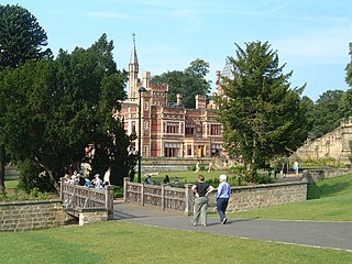
Saltwell Park is a Victorian park in Gateshead, Tyne and Wear, England. Opened in 1876, the park was designed by Edward Kemp and incorporates the mansion and associated grounds of the Saltwellgate estate owner, William Wailes, who sold his estate to Gateshead Council for £35,000. Upon opening, it became known as "The People's Park". The park was expanded in 1920 when the council purchased the adjacent gardens to the Saltwell Grove estate and added these to the park. This extended the park's total size to 55 acres (22 ha). Towards the end of the 20th century, the park had fallen into disrepair, but between 1999 and 2005, it was subject to a £9.6 million restoration project, funded collaboratively by the Heritage Lottery Fund and Gateshead Council and is now host to around 2 million visitors per year.
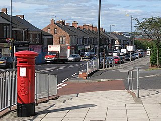
Pelaw is a residential area in Gateshead, located around 3.5 miles (5.6 km) from Newcastle upon Tyne, 11 miles (18 km) from Sunderland, and 17 miles (27 km) from Durham. In 2011, Census data for the Gateshead Metropolitan Borough Council ward of Heworth and Pelaw recorded a total population of 9,100.
Sheriff Hill is a suburb in the Metropolitan Borough of Gateshead in Tyne and Wear, England. It lies on the B1296 road 2 miles (3.2 km) south of Gateshead, 2.5 miles (4.0 km) south of Newcastle upon Tyne and 12 miles (19 km) north of the historic city of Durham. According to the 2001 UK census it had a population of 5,051.
Wrekenton is a residential area in Gateshead, located around 3.5 miles (5.6 km) from Newcastle upon Tyne, 11 miles (18 km) from Sunderland, and 14 miles (23 km) from Durham. In 2011, Census data for the Gateshead Metropolitan Borough Council ward of High Fell recorded a total population of 6,110.

North Kenton is a suburban housing estate in the City of Newcastle upon Tyne, in Tyne and Wear, England, located north west of the city centre and to the east of Kingston Park.
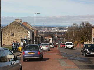
Sunniside is a village in the Metropolitan Borough of Gateshead, which is located around 5.5 miles (9 km) from Newcastle upon Tyne. Prior to the creation of the county of Tyne and Wear in 1974, it was part of Whickham Urban District, which in turn formed a part of County Durham.

Leam Lane Estate is a housing estate in Gateshead, built in the 1950s and early 60's. Originally made up solely of council-built accommodation and housing association houses. Most of the properties are now privately owned. The estate is located around 4 miles (6.4 km) from Newcastle upon Tyne, 10.5 miles (16.9 km) from Sunderland, and 15.5 miles (24.9 km) from Durham. In 2011, Census data for the Gateshead Metropolitan Borough Council ward of Wardley and Leam Lane recorded a total population of 8,327.

Windy Nook is an area in Tyne and Wear, England, bordered by Carr Hill to the west, Whitehills Estate and Leam Lane Estate to the east, Felling to the north and Sheriff Hill to the south. It lies on steep, sloping land 2.25 miles (3.62 km) south of Gateshead, 2.75 miles (4.43 km) south of Newcastle upon Tyne and 12 miles (19 km) north of Durham. In 2011, the Windy Nook and Whitehills ward had a population of 9,781. Formerly part of Heworth, it was incorporated into the newly formed Metropolitan Borough of Gateshead on 1 April 1974.

Carr Hill is a suburb in the Metropolitan Borough of Gateshead in Tyne and Wear, England. It is bordered by Felling to the north, Sheriff Hill to the south, Windy Nook to the east and Deckham to the west. It lies 1.5 miles (2.4 km) south of Gateshead, 2 miles (3.2 km) south of the city of Newcastle upon Tyne and 13 miles (21 km) north of the historic City of Durham. Once a village in County Durham, it was incorporated into the Metropolitan Borough of Gateshead by the Local Government Act 1972 on 1 April 1974.
Bensham is a suburban area in the Metropolitan Borough of Gateshead. The area consists mainly of residential properties, with a range of predominantly terraced housing, built between the late 1890s and the 1980s.

