
Niton is a village and former civil parish, now in the parish of Niton and Whitwell, on the Isle of Wight, England. It is west of Ventnor, with a population of 2,082. It has two pubs, several churches, a pottery workshop/shop, a pharmacy, a busy volunteer-run library, a medical centre and two local shops including a post office. The post office includes a pub and café that serves as a local meeting place. The village also offers a primary school with a co-located pre-school and nursery.

The River Yar on the Isle of Wight, England, rises in a chalk coomb in St. Catherine's Down near Niton, close to the southern tip of the island. It flows across the Lower Cretaceous rocks of the eastern side of the island, through the gap in the central Upper Cretaceous chalk ridge of the Island at Yarbridge, then across the now drained Brading Haven to Bembridge Harbour in the northeast.

Whitwell is a small village and former civil parish, now in the parish of Niton and Whitwell, on the south of the Isle of Wight, England, approximately 5 kilometres north-west of Ventnor, the village's nearest town. In addition to this, it is about five minutes away from its neighbouring small villages of Godshill and Niton. According to 2001 census data, the total population of the village was 578. There is a variety of stone and thatched housing, as well as some more modern housing, the most recent of which was completed in 2006.

Chale is a village and civil parish on the Isle of Wight of England, in the United Kingdom. It is located three kilometres from Niton in the south of the Island in the area known as the Back of the Wight. The village of Chale lies at the foot of St. Catherine's Down.

St Catherine's Point is the southernmost point on the Isle of Wight. It is close to the village of Niton and the point where the Back of the Wight changes to the Undercliff of Ventnor.

St. Catherine's Oratory is a medieval lighthouse on St. Catherine's Down, above the southern coast of the Isle of Wight. It was built by Lord of Chale Walter de Godeton as an act of penance for plundering wine from the wreck of St. Marie of Bayonne in Chale Bay on 20 April 1313. The tower is known locally as the "Pepperpot" because of its likeness to a pepper shaker.
A Pepperpot or Salt Shaker lighthouse is a type of small lighthouse that has an architectural style similar to a scaled up salt or pepper shaker. These lighthouses feature a square tapered base with a single gallery and a square lantern. They are usually shingled in wood and painted white; the lantern and trim are red. Many such lighthouses still exist across Canada, especially in the Maritime provinces.

The A3055 is an A-Class Road on the Isle of Wight in Southern England. It forms the Southern portion of the circular around-the-Island A-class loop, the northern section being the A3054. The stretch along the south-west coast of the Island is formed by the Military Road.

Luccombe is a hamlet a short distance south of Shanklin, on the south coast of the Isle of Wight, England.
Tennyson Down is a hill at the west end of the Isle of Wight just south of Totland. Tennyson Down is a grassy, whale-backed ridge of chalk which rises to 482 ft/147m above sea level. Tennyson Down is named after the poet Lord Tennyson who lived at nearby Farringford House for nearly 40 years. The poet used to walk on the down almost every day, saying that the air was worth 'sixpence a pint'.
Puckaster is a hamlet on the Isle of Wight, England. Puckaster is on the southern coast of the Isle of Wight, south of Niton, between St Catherine's Point and Binnel.
M/V Pool Fisher was a British merchant vessel that sank off the Isle of Wight on 6 November 1979 with the loss of most of her crew.

The Isle of Wight Coastal Path is a circular long-distance footpath of 70 miles (113 km) around the Isle of Wight, UK. It follows public footpaths and minor lanes, with some sections along roads.

Chale Bay is a bay on the south-west coast of the Isle of Wight, England. It lies to the west of the village of Chale from which it takes its name. It faces south-west towards the English Channel, its shoreline is 3+1⁄4 miles (5.2 km) in length and is gently curving. It stretches from Artherfield Point in the north-west to Rocken End in the south-east.
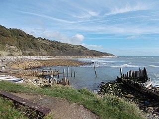
Watershoot Bay is a bay on the southernmost tip of the Isle of Wight, England. It lies 1+1⁄2 miles (2.4 km) to the south-west of the village of Niton. It faces south out into the English Channel, and is one of the smallest and remotest bays of the Isle of Wight with a rocky shoreline only around 500 feet (150 m) in length. It lies to the west of St. Catherine's Point lighthouse and is surrounded by a 170-acre area of undulating grassland and scrub owned by the National Trust and known as Knowles Farm.
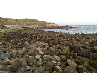
Reeth Bay is a small curved bay on the southernmost tip of the Isle of Wight, England. It lies to the south of the village of Niton with a 1⁄4-mile-long (0.4 km) shoreline. It faces south out into the English Channel and lies to the east of St. Catherine's Point lighthouse. It is at the centre of a small hamlet called Castlehaven where there is a concrete ramp for launching small craft. The beach is predominantly sand and pebbles. The seabed is a mixture of rocks and mud. The bay is best accessed from the road from Niton that leads down to the bay.

Back of the Wight is an area on the Isle of Wight in England. The area has a distinct historical and social background, and is geographically isolated by the chalk hills, immediately to the North, as well as poor public transport infrastructure. Primarily agricultural, the Back of the Wight is made up of small villages spread out along the coast, including Brighstone, Shorwell and Mottistone.

St Catherine's Lighthouse is a lighthouse located at St Catherine's Point at the southern tip of the Isle of Wight. It is one of the oldest lighthouse locations in Great Britain.
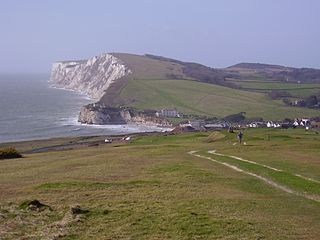
The Undercliff, Isle of Wight, England is a tract of semi-rural land, around 5 miles (8.0 km) long by 0.25–0.5 miles (0.40–0.80 km) wide, skirting the southern coast of the island from Niton to Bonchurch. Named after its position below the escarpment that backs this coastal section, its undulating terrain comprises a mix of rough pasture, secondary woodland, parkland, grounds of large isolated houses, and suburban development. Its sheltered south-facing location gives rise to a microclimate considerably warmer than elsewhere on the island. Although inhabited, the Undercliff is an area prone to landslips and subsidence, with accompanying loss of property over time. Settlements along the Undercliff, from west to east, are: lower Niton, Puckaster, St Lawrence, Steephill, the town of Ventnor, and Bonchurch.


