
The St. Clair River is a 40.5-mile-long (65.2 km) river in central North America which flows from Lake Huron into Lake St. Clair, forming part of the international boundary between the Canadian province of Ontario and the United States at Michigan. The river is a significant component in the Great Lakes Waterway, whose shipping channels permit cargo vessels to travel between the upper and lower Great Lakes.
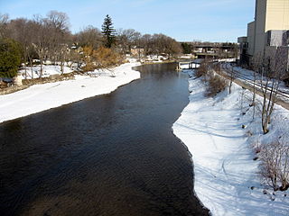
The Sydenham River is a river in Chatham-Kent, Lambton County and Middlesex County in southwestern Ontario, Canada, flowing southwest from its source west of London, Ontario and emptying into Lake Saint Clair. The length of the river is 165 kilometres (103 mi) and it drains a watershed of approximately 2,700 square kilometres (1,000 sq mi). The river flows through the towns of Strathroy and Wallaceburg. It was named after Lord Sydenham, governor of Canada from 1839 to 1841.

The Abitibi River is a river in northeastern Ontario, Canada, which flows northwest from Lake Abitibi to join the Moose River which empties into James Bay. This river is 540 kilometres (340 mi) long, and descends 265 metres (869 ft).
Catfish Creek is a creek in Elgin County in southwestern Ontario which empties into the north shore of Lake Erie. Catfish Creek begins in the northwest area of Aylmer and flows in a generally southern direction before flowing into Lake Erie at Port Bruce. It is a significant creek in that it flows through an area of Carolinian forest. Worthy of note is the area just northwest of Port Bruce called the Catfish Creek Slope and Floodplain Forest. "Encompassing 233 hectares, this unique Area of Natural and Scientific Interest contains some of the most endangered habitat in Canada. It lies in the heart of the Carolinian Zone of Southern Ontario and provides mature, deciduous forest cover that is able to support plant and animal life normally found much further south. All of this Carolinian Canada site is privately owned."
The Speed River is a river that flows through Wellington County and the Region of Waterloo in southwestern Ontario, Canada. It flows south from its source near Orton, through Guelph, where it is joined by the Eramosa River, then through the towns of Hespeler and Preston, finally uniting with the Grand River in north-west Cambridge.
A conservation authority is a local, community-based natural resource management agency based in Ontario, Canada. Conservation authorities represent groupings of municipalities on a watershed basis and work in partnership with other agencies to carry out natural resource management activities within their respective watersheds, on behalf of their member municipalities and the Province of Ontario.

The Grand River Conservation Authority (GRCA) is a conservation authority in Ontario, Canada. It operates under the Conservation Authorities Act of Ontario. It is a corporate body, through which municipalities, landowners and other organizations work cooperatively to manage the Grand River watershed and natural resources within it.
King's Highway 40, commonly referred to as Highway 40, is a provincially maintained highway in the southwestern portion of the Canadian province of Ontario. The 91.4-kilometre (56.8 mi) route links Chatham and Sarnia via Wallaceburg, following close to the St. Clair River. The southern terminus is at Highway 401 south of Chatham, while the northern terminus is at Highway 402 in Sarnia. The portion of Highway 40 between Highway 401 and north of Wallaceburg is within the municipality of Chatham-Kent, while the portion north of there is within Lambton County.

The Lake Simcoe Region Conservation Authority is a conservation authority established in 1951, and is among the oldest in the Canadian province of Ontario.

Conservation Ontario is the umbrella organization which represents all of the conservation authorities in Ontario. This nonprofit organization was founded in 1980/81. Conservation Ontario is the network of 36 Conservation Authorities.

Lambton—Kent—Middlesex is a provincial electoral district in southwestern Ontario, Canada. It elects one member to the Legislative Assembly of Ontario.
Hay Swamp is a provincially significant wetland complex, 1839 hectares in size, located in parts of the central land areas of the municipalities of Bluewater and South Huron, in southwestern Ontario, Canada. Approximately 13 kilometers (8.1 mi) in length and 2 kilometers (1.2 mi) in width, at its widest point; it consists of 15 extensively forested individual wetlands, situated on either side, of sections of both the upper drainage of the Ausable River and its tributary, Black Creek.
The Nickel District Conservation Authority is a conservation authority in Greater Sudbury, Ontario. Formed in 1973 by the merger of two former conservation authorities in the region, the Junction Creek Conservation Authority in Sudbury and the Whitson Valley Conservation Authority in Valley East, the authority oversees the conservation, restoration, development and management of natural resources in the Sudbury area.
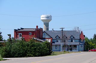
Pain Court is a primarily French-speaking agricultural village in southwestern Ontario, Canada, in the municipality of Chatham-Kent. It was established in 1854, as one of the earliest French-speaking settlements in southern Ontario. Pain Court was founded when English and French-speaking squatters from the Detroit, Michigan, area began to settle the indigenous lands along the lower Thames River in the region in the 1780s. It derived its name from the small loaves of bread which the impoverished parishioners offered to Roman Catholic missionaries.
Wychwood Park is a neighbourhood enclave and private community in Toronto, Ontario, Canada. It is located west of Bathurst Street on the north side of Davenport Road, within the larger area of Bracondale Hill. It is considered part of the overall Wychwood official neighbourhood as designated by the City of Toronto.

Lake Erie Basin consists of Lake Erie and surrounding watersheds, which are typically named after the river, creek, or stream that provides drainage into the lake. The watersheds are located in the states of Indiana, Michigan, New York, Ohio, and Pennsylvania in the United States, and in the province of Ontario in Canada. The basin is part of the Great Lakes Basin and Saint Lawrence River Watershed, which feeds into the Atlantic Ocean. 80% of the lake's water flows in from the Detroit River, with only 9% coming from all of the remaining watersheds combined. A littoral zone serves as the interface between land and lake, being that portion of the basin where the lake is less than 15 feet (4.6 m) in depth.

The St. Lawrence Parks Commission is a Crown agency of the Government of Ontario that manages parks and heritage sites along the shoreline of the St. Lawrence River in southeastern Ontario. It functions similarly to the Niagara Parks Commission's role in overseeing attractions and conservation on the Ontario side of the Niagara River.
Buttermilk Creek is a creek in the town of Petrolia, Lambton County, Ontario, Canada.
The Huron Tract Purchase also known as the Huron Block, registered as Crown Treaty Number 29, is a large area of land in southwestern Ontario bordering on Lake Huron to the west and Lake Erie to the east. The area spans the counties of Huron, Perth, Middlesex and present day Lambton County, Ontario in the province of Ontario.
The Gardens of Fanshawe College were started in 1995 when St. Pauls Cathedral was looking for land within London, Ontario to create a memorial garden of tree plantings in the names of deceased Londoners. They approached Fanshawe College after locating a large expanse of vacant land in the area. Subsequently, after discussions concerning upkeep and possible vandalism, Fanshawe set aside an area now known as Woodland Gardens in 1995. An organized and accessioned garden was begun after this time and the Spriet Family Greenhouse was added to the Horticulture Technician Program. The gardens have now evolved into The Gardens of Fanshawe College which also include The A. M. Mac Cuddy Gardens, some forty minutes west of London north of the town of Strathroy.