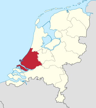
South Holland is a province of the Netherlands with a population of over 3.7 million as of October 2021 and a population density of about 1,373/km2 (3,560/sq mi), making it the country's most populous province and one of the world's most densely populated areas. Situated on the North Sea in the west of the Netherlands, South Holland covers an area of 3,307 km2 (1,277 sq mi), of which 607 km2 (234 sq mi) is water. It borders North Holland to the north, Utrecht and Gelderland to the east, and North Brabant and Zeeland to the south. The provincial capital is the Dutch seat of government The Hague, while its largest city is Rotterdam. The Rhine-Meuse-Scheldt delta drains through South Holland into the North Sea. Europe's busiest seaport, the Port of Rotterdam, is located in South Holland.
The Delta Works is a series of construction projects in the southwest of the Netherlands to protect a large area of land around the Rhine–Meuse–Scheldt delta from the sea. Constructed between 1954 and 1997, the works consist of dams, sluices, locks, dykes, levees, and storm surge barriers located in the provinces of South Holland and Zeeland.

Dordrecht, historically known in English as Dordt or Dort, is a city and municipality in the Western Netherlands, located in the province of South Holland. It is the province's fifth-largest city after Rotterdam, The Hague, Zoetermeer and Leiden, with a population of 119,115.

Geertruidenberg is a city and municipality in the province North Brabant in the south of the Netherlands. The city, named after Saint Gertrude of Nivelles, received city rights in 1213 from the count of Holland. The fortified city prospered until the 15th century.

Storm tides of the North Sea are coastal floods associated with extratropical cyclones crossing over the North Sea, the severity of which is affected by the shallowness of the sea and the orientation of the shoreline relative to the storm's path, as well as the timing of tides. The water level can rise to more than 5 metres (17 ft) above the normal tide as a result of storm tides.

The Hook and Cod wars comprise a series of wars and battles in the County of Holland between 1350 and 1490. Most of these wars were ostensibly fought over who should hold the title of "Count of Holland", but some have argued that the underlying reason was a power struggle conducted by the bourgeois in the cities against the ruling nobility.

Kinderdijk is a village in the municipality of Molenlanden, in the province of South Holland, Netherlands. It is located about 15 km east of Rotterdam.

The 1953 North Sea flood was a major flood caused by a heavy storm surge that struck the Netherlands, north-west Belgium, England and Scotland. Most sea defences facing the surge were overwhelmed, resulting in extensive flooding.

De Biesbosch National Park is one of the largest national parks in the Netherlands and one of the last extensive areas of freshwater tidal wetlands in Northwestern Europe. The Biesbosch consists of a large network of rivers and smaller and larger creeks with islands. The vegetation is mostly willow forests, although wet grasslands and fields of reed are common as well. The Biesbosch is an important wetland area for waterfowl and has a rich flora and fauna. It is especially important for migrating geese.
The All Saints' Flood of 1570 occurred on November 1–2, 1570, and is considered the worst North Sea flood disaster before the 20th century. It flooded the entire coast of the Netherlands and East Frisia. The effects were felt from Calais in Flanders to Jutland and even Norway. Even though the alleged casualty figures were mostly based on rough estimates and should be viewed with skepticism, up to 25,000 deaths can be assumed.

Numansdorp is a town and former municipality in the province South Holland in the Netherlands and is located on the island Hoeksche Waard near the Hollands Diep. On 1 January 1984, the municipalities Numansdorp and Klaaswaal were merged into one municipality called Cromstrijen. Cromstrijen was merged into the new municipality Hoeksche Waard in January 2019.
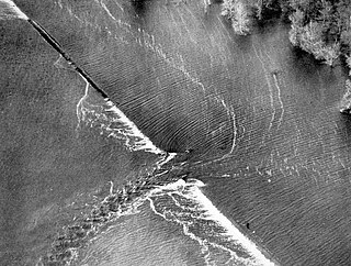
A levee breach or levee failure is a situation where a levee fails or is intentionally breached, causing the previously contained water to flood the land behind the levee.

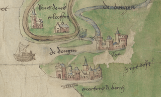
The Grote Waard or Hollandse Waard was a farming region in the County of Holland at the border of the Duchy of Brabant, that disappeared in the St. Elizabeth's flood. Parts of this polder are now separated by water: Hoekse Waard, Eiland van Dordrecht, De Biesbosch, and parts of North Brabant. The Grote Waard was a damp peat region, which was roughly limited by what now is the Afgedamde Maas between Heusden and Woudrichem, the Boven Merwede and Beneden Merwede, Dordrecht, Maasdam, the Keizersdijk between Maasdam and Strijen, Strijensas, Lage Zwaluwe, and Hooge Zwaluwe.

Flood control is an important issue for the Netherlands, as due to its low elevation, approximately two thirds of its area is vulnerable to flooding, while the country is densely populated. Natural sand dunes and constructed dikes, dams, and floodgates provide defense against storm surges from the sea. River dikes prevent flooding from water flowing into the country by the major rivers Rhine and Meuse, while a complicated system of drainage ditches, canals, and pumping stations keep the low-lying parts dry for habitation and agriculture. Water control boards are the independent local government bodies responsible for maintaining this system.

The Battle of Zwartewaal was a decisive naval battle during the Hook and Cod wars.

Maasdam is a village in the Dutch province of South Holland. It is located about 14 km south of the city of Rotterdam, in the municipality of Hoeksche Waard, on the rural Hoeksche Waard island. From the 14th Century until around 1800, Maasdam was also the name of the local administrative area, the fief and later the "ambacht".
Hooge Zwaluwe is a village in the Dutch province of North Brabant. It is located in the municipality of Drimmelen, about 3.5 km north-west of Made.

The Stormvloedkering Hollandse IJssel, Hollandse IJsselkering or Algerakering is a storm surge barrier located on the Hollandse IJssel, at the municipal boundary of Capelle aan den IJssel and Krimpen aan den IJssel, east of Rotterdam in The Netherlands. The construction of the works comprised the first project of the Delta Works, undertaken in response to the disastrous effects of the North Sea flood of 1953. Prior to 1954, the spelling Hollandsche was used in the official name.
Geertruidenberg Castle was a major medieval castle in Geertruidenberg, then part of County of Holland now in North-Brabant, Netherlands

