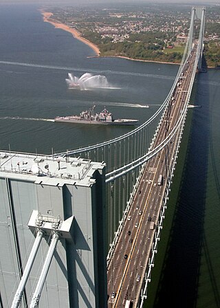
Staten Island is a borough of New York City, coextensive with Richmond County, in the U.S. state of New York. Located in the city's southwest portion, the borough is separated from New Jersey by the Arthur Kill and the Kill Van Kull and from the rest of New York by New York Bay. With a population of 495,747 in the 2020 Census, Staten Island is the least populated borough but the third largest in land area at 58.5 sq mi (152 km2).

William Henry Vanderbilt was an American businessman and philanthropist. He was the eldest son of Commodore Cornelius Vanderbilt, an heir to his fortune and a prominent member of the Vanderbilt family. Vanderbilt became the richest American after he took over his father's fortune in 1877 until his own death in 1885, passing on a substantial part of the fortune to his wife and children, particularly to his sons Cornelius II and William. He inherited nearly $100 million from his father. The fortune had doubled when he died less than nine years later.

New Dorp is a neighborhood on the East Shore of Staten Island, New York City, United States. New Dorp is bounded by Mill Road on the southeast, Tysens Lane on the southwest, Amboy and Richmond Roads on the northwest, and Bancroft Avenue on the northeast. It is adjacent to Oakwood to the southwest, Todt Hill to the northwest, Dongan Hills and Grant City, and Midland Beach and Miller Field to the southeast. New Dorp Beach, bordering to the east, is often listed on maps as a separate neighborhood from Mill Road to the shore of Lower New York Bay, but is generally considered to be a part of New Dorp.

St. George is a neighborhood on the northeastern tip of Staten Island in New York City, along the waterfront where the Kill Van Kull enters Upper New York Bay. It is the most densely developed neighborhood on Staten Island, and the location of the administrative center for the borough and for the coterminous Richmond County. The St. George Terminal, serving the Staten Island Ferry and the Staten Island Railway, is also located here. St. George is bordered on the south by the neighborhood of Tompkinsville and on the west by the neighborhood of New Brighton.

Midland Beach is a neighborhood of Staten Island in New York City. It lies along the east-central coast of the island, in the area known locally as the "Mid-Island, Staten Island" or the "East Shore".
Mid-Island is frequently applied to a series of neighborhoods within the New York City borough of Staten Island.

South Beach is a neighborhood on the East Shore of Staten Island, New York City, situated directly south of the Verrazzano-Narrows Bridge. South Beach is bounded by New York Bay on the southeast, Seaview Avenue on the southwest, Laconia Avenue on the northwest, Reid and McClean Avenues on the north, and Lily Pond Avenue on the northeast. It is adjacent to Midland Beach to the southwest, Dongan Hills and Old Town/Concord to the northwest, and Fort Wadsworth and Rosebank to the northeast.

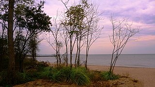
New Dorp Beach is along the shore of the neighborhood of New Dorp, on Staten Island, one of the five boroughs of New York City. It is between Midland Beach and Oakwood Beach.

New Dorp High School, commonly referred to as New Dorp or NDHS, is a public school in New Dorp on the East Shore of the New York City borough of Staten Island in the New Dorp neighborhood. The school is administered by the New York City Department of Education. The school is located at 465 New Dorp Lane next to Miller Field, an army airport turned park, which extends to the Lower New York Bay. New Dorp High School is located in Region 7, which encompasses all of Staten Island and portions of southwest Brooklyn.

Hylan Boulevard is a major northeast-southwest boulevard in the New York City borough of Staten Island, and the longest street in the city. It is approximately 14 miles (23 km) long, and runs from the North Shore neighborhood of Rosebank, then along the entire East Shore, to the South Shore neighborhood of Tottenville. It was renamed in 1923 for New York City mayor John F. Hylan, before which it was known as Southfield Boulevard and the northern segment as Pennsylvania Avenue.

The New Dorp Lighthouse is a decommissioned lighthouse located in the New Dorp section of Staten Island, New York City. Funds for the lighthouse were approved by United States Congress on August 31, 1852 and the structure was completed in 1856. The lighthouse, built to serve as a rear range light to mark Swash Channel, was built by Richard Carlow, who also built the similar Chapel Hill and Point Comfort Range Lights in New Jersey around the same time. Ships sailing through Swash Channel were instructed to bring the New Dorp range light “in one” and steer towards the lights until the Chapel Hill Light came into view, which would then mark the channel past West Bank.

Father Capodanno Boulevard, formerly Seaside Boulevard, is the primary north-south artery that runs through the Arrochar, South Beach, Ocean Breeze, Midland Beach, and New Dorp Beach neighborhoods of the New York City borough of Staten Island. The boulevard runs parallel to the South Beach Boardwalk and its public park.
The Church of St. Roch is a Roman Catholic parish church in the Roman Catholic Archdiocese of New York, located at 602 Port Richmond Avenue, Staten Island, New York City. It was established in 1922. It is sometimes confused with St. Roch's Church St. in the Bronx, which was established in 1899.

The Church of St. Peter is a parish church under the authority of the Roman Catholic Archdiocese of New York, located in Staten Island, New York City in the neighborhood of New Brighton. St. Peter's is the oldest of the 36 Roman Catholic parishes on Staten Island, having been established in 1839, before the second-oldest St. Mary's (1852) and the third-oldest St. Joseph's (1855).

The Church of Our Lady of Pity is a Roman Catholic parish church under the authority of the Roman Catholic Archdiocese of New York, located in Staten Island, New York City. The church is located at 1616 Richmond Avenue, just south of the Staten Island Expressway.

The Floating Hospital is a non-profit organization that provides healthcare services to medically underserved communities in New York City, both from its headquarters in Long Island City, Queens and from satellite offices in Brooklyn and the Bronx. Though today it is a land-based organization, the organization operated a succession of vessels which frequently cruised New York Harbor and nearby waterways, giving indigent children and their caregivers a respite from overcrowded tenements. While they were aboard, the Floating Hospital's staff of pediatricians, dentists, nurses, and social workers would provide healthcare services to children and health and nutrition education to their caregivers.

The Staten Island Railway (SIR) is the only rapid transit line in the New York City borough of Staten Island and is operated by the Staten Island Rapid Transit Operating Authority, a unit of the Metropolitan Transportation Authority. The railway was historically considered a standard railroad line, but today only the western portion of the North Shore Branch, which is disconnected from the rest of the SIR, is used by freight and is connected to the national railway system.
This is a timeline of Staten Island.
William John Jankunis is an American athlete. He competed in the men's high jump at the 1976 Summer Olympics. Jankunis won the 1976 United States Summer Olympic High Jump Trials on June 28, 1976, at University of Oregon's Hayward Stadium with a jump of 2.28 metres.


