
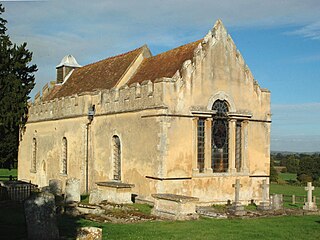
St Andrew's Church is an Anglican parish church in Naunton, Gloucestershire, dedicated to St Andrew the Apostle.
St Andrew's Church is an Anglican parish church in Naunton, Gloucestershire, dedicated to St Andrew the Apostle.
Dating from the 13th century, the church replaced a Saxon church on the same site. It was rebuilt in the 15th, when a tower was added, and restored in 1878. It was named a Grade II* listed building in 1960. [1] [2] [3]
It has two 18th-century sundials, one inscribed in Latin Lux Umbra Dei: "Light [is] the shadow of God." [4]
The Renaissance playwright and poet Ulpian Fulwell was Rector of Naunton from about 1570 until his death in about 1586, but seems to have neglected his clerical duties. An episcopal visitation in 1572 concluded that the church building was decaying. Four years later Fulwell was fined when his clerk was found to be illiterate and that parents had ceased to send their children to catechism classes. [5]
Another Rector, from 1660, was the prolific author and translator Clement Barksdale (1609–1687), who held the parish in plurality with Stow-on-the-Wold.
At present the parish of Naunton is part of the Archdeaconry of Cheltenham in the Diocese of Gloucester. [6] The church has opted to continue using the 1662 Book of Common Prayer for its services. [7]

Northleach is a market town in Northleach with Eastington civil parish in Gloucestershire, England. The town is in the valley of the River Leach in the Cotswolds, about 10 miles (16 km) northeast of Cirencester and 11 miles (18 km) east-southeast of Cheltenham. The 2011 Census recorded the parish's population as 1,854.

Adlestrop is a village and civil parish in the valley of the River Evenlode in the Cotswolds about 3 miles (5 km) east of Stow-on-the-Wold in Gloucestershire, England. The parish is on the county boundary with Oxfordshire. The River Evenlode forms the southwest boundary of the parish. The village is on a stream that flows southwest to join the river.

Cromhall is a village in South Gloucestershire, England. It is located between Bagstone and Charfield on the B4058, and also borders Leyhill. The parish population taken at the 2011 census was 1,231.

Ampney St Peter is a small village and civil parish in the Cotswolds, part of the Cotswold of Gloucestershire, England. According to the 2014 mid year estimate the parish has a population of 75. Locally the town was known as Easington.

Birtsmorton is a village and civil parish in the Malvern Hills of Worcestershire, England, which at the 2001 census had a population of 250. It is in the south-west of the county, not far from the borders with Herefordshire and Gloucestershire.

Leckhampton is a district in south Cheltenham, Gloucestershire, England. The area is in the civil parish of Leckhampton with Warden Hill and is part of the district of Cheltenham. The population of the civil parish taken at the 2011 census was 4,409.

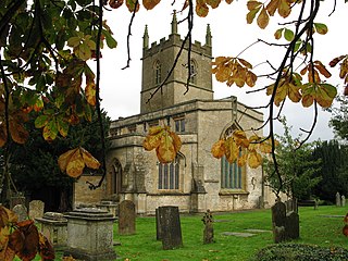
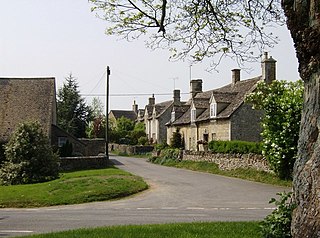
Naunton is a village in Gloucestershire, England. It lies on the River Windrush in the Cotswolds, an area of outstanding natural beauty. Stow-on-the-Wold is about 6 miles to the east.

Hampton Hill is a district in the London Borough of Richmond upon Thames to the south of Twickenham, bounded by Fulwell and Twickenham Golf Course to the northwest; the road bridge over the railway line; a line southward just east of Wellington Road; Bushy Park to the southeast; and the artificial Longford River to the south and west. It is served by Fulwell railway station and Hampton railway station on the Shepperton to Waterloo line. It is part of what is collectively known as The Hamptons.

Finmere is a village and civil parish in Oxfordshire, south of the River Great Ouse. It is on the county boundary with Buckinghamshire, almost 4 miles (6 km) west of Buckingham and just over 4 miles (6 km) east of Brackley in Northamptonshire. The 2011 Census recorded the parish's population as 466.

Enstone is an English village and civil parish about 4 miles (6.4 km) east of Chipping Norton, and 15 miles (24 km) north-west of Oxford city. The civil parish, one of the largest in Oxfordshire, consists of the villages of Church Enstone and Neat Enstone, with the hamlets of Chalford, Cleveley, Fulwell, Gagingwell, Lidstone, and Radford. The 2011 Census recorded the parish population as 1,139, living in 453 households. The parish population was estimated at 1,256 in 2019.
Wheatfield is a civil parish and deserted medieval village about 4 miles (6.4 km) south of Thame in Oxfordshire.
St Edward's Church is a medieval-built Church of England parish church, serving Stow-on-the-Wold ('Stow'), Gloucestershire.

Miserden is a village and civil parish in Stroud District, Gloucestershire, England, 4 miles north east of Stroud. The parish includes Whiteway Colony and the hamlets of Sudgrove and The Camp. In the 2001 census the parish had a population of 420, increasing to 449 at the 2011 census.
Cold Aston is a village and civil parish in Gloucestershire, England, approximately 30 km (19 mi) to the east of Gloucester. It lies in the Cotswolds, an Area of Outstanding Natural Beauty.

Somerton is a village and civil parish in Oxfordshire, England, in the Cherwell valley about 6 miles (10 km) northwest of Bicester. The 2011 Census recorded the parish's population as 305.

Mixbury is a village and civil parish in Oxfordshire, about 2.5 miles (4 km) southeast of Brackley in Northamptonshire.

Maisemore is a village and civil parish in Gloucestershire, England. It lies on the A417 road 2.5 miles (4 km) northwest of Gloucester, on the west bank of the River Severn. In the 2001 census the parish had a population of 488, reducing to 458 at the 2011 census.
Ulpian Fulwell was an English Renaissance theatre playwright, satirist and poet. Later as a Gloucestershire parish priest, he appears to have neglected his duties.

St Mary's Church is a Church of England parish church in Longworth, Oxfordshire. The church is a Grade I listed building.

Temple Guiting is a village and civil parish in the Cotswolds, in Gloucestershire, England. The civil parish includes the smaller settlements of Barton, Farmcote, Ford and Kineton. In 2011 the parish had a population of 463.
| Wikimedia Commons has media related to St Andrew's Church, Naunton . |