
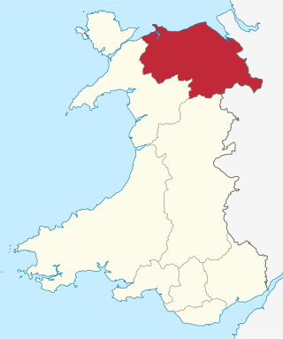
Denbighshire is a county in the north-east of Wales. It borders the Irish Sea to the north, Flintshire to the east, Wrexham to the southeast, Powys to the south, and Gwynedd and Conwy to the west. Rhyl is the largest town, and Ruthin is the administrative centre. Its borders differ from the historic county of the same name.

Until 1974, Denbighshire, or the County of Denbigh, was an administrative county in the north of Wales, later classed as one of the thirteen historic counties of Wales. It was a maritime county, that was bounded to the north by the Irish Sea, to the east by Flintshire, Cheshire and Shropshire, to the south by Montgomeryshire and Merionethshire, and to the west by Caernarfonshire.
Clwyd is a preserved county of Wales, situated in the north-east corner of the country; it is named after the River Clwyd, which runs through the area. To the north lies the Irish Sea, with the English ceremonial counties of Cheshire to the east and Shropshire to the south-east. Powys and Gwynedd lie to the south and west respectively. Clwyd also shares a maritime boundary with Merseyside along the River Dee. Between 1974 and 1996, a slightly different area had a county council, with local government functions shared with six district councils. In 1996, Clwyd was abolished, and the new principal areas of Conwy County Borough, Denbighshire, Flintshire and Wrexham County Borough were created; under this reorganisation, "Clwyd" became a preserved county, with the name being retained for certain ceremonial functions.
Baron Clwyd, of Abergele in the County of Denbigh, is a title in the Peerage of the United Kingdom. It was created in 1919 for the Liberal politician Sir John Roberts, 1st Baronet, who had previously represented Denbighshire West in the House of Commons. He had already been created a Baronet, of Brynwenallt in the parish of Abergele in the County of Denbigh, in the Baronetage of the United Kingdom in 1908. Lord Clwyd's father John Roberts had earlier been Member of Parliament for Flint from 1878 to 1892. As of 2016 the titles are held by his great-grandson, the fourth Baron, who succeeded his father in 2006.

St Asaph is a city and community on the River Elwy in Denbighshire, Wales. In the 2011 Census it had a population of 3,355, making it the second-smallest city in the United Kingdom in terms of population and urban area. It is in the historic county of Flintshire.
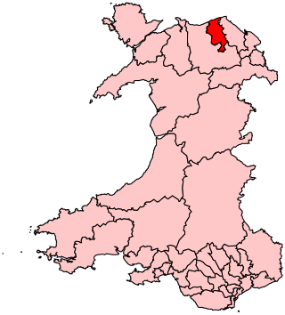
The Vale of Clwyd is a constituency of the House of Commons of the UK Parliament created in 1997 and represented since 2019 by James Davies of the Conservative Party. As with all extant seats its electorate elect one Member of Parliament (MP) by the first past the post system at least every five years.
The Vale of Clwyd is a tract of low-lying ground in the county of Denbighshire in north-east Wales. The Vale extends south-southwestwards from the coast of the Irish Sea for some 20 miles forming a triangle of low ground bounded on its eastern side by the well-defined scarp of the Clwydian Range and to the west by numerous low hills. The River Clwyd which rises within Clocaenog Forest, southwest of Denbigh, runs the full length of the vale. It is joined by the two major left bank tributaries of the River Clywedog and River Elwy and the smaller right bank tributary of the River Wheeler.

The Borough of Rhuddlan was a local government district with borough status from 1974 to 1996, being one of six districts in the county of Clwyd, north-east Wales.
Christ the Word Catholic School is a Catholic co-educational voluntary aided secondary school situated on Cefndy Road, in Rhyl, Denbighshire. It opened in September 2019 and is an English-medium school. It replaced both a secondary school, Blessed Edward Jones Catholic School and primary school, Ysgol Mair, meaning that it teaches pupils from ages 3 to 16.
Aled was a rural district in the administrative county of Denbighshire, Wales, from 1935 to 1974.
Denbigh was a county constituency centred on the town of Denbigh in North Wales. It returned one Member of Parliament (MP) to the House of Commons of the Parliament of the United Kingdom, elected by the first-past-the-post voting system.
Conwy & Denbighshire NHS Trust was an NHS Trust in Wales. The headquarters of the Trust were in Glan Clwyd Hospital, in Bodelwyddan, near Rhyl, Denbighshire. The Trust was named in the 'Top 40 Hospitals' in the UK for the fifth year running in 2006, a title conferred by CHKS.

Abergele Hospital is a community hospital in Abergele, Wales. It is managed by Betsi Cadwaladr University Health Board.
Denbigh District of Boroughs was a parliamentary constituency centred on the town of Denbigh in Wales. It returned one Member of Parliament (MP) to the British House of Commons.
Thomas Williams (1658–1726) was a Welsh Anglican priest and translator.
The Rhyl Deanery is a Roman Catholic deanery in the Diocese of Wrexham that covers several churches in Conwy and Denbighshire.
Thomas Lloyd was a Welsh Anglican bishop in the first half of the 20th century.

Betsi Cadwaladr University Health Board (BCUHB) is the local health board of NHS Wales for the north of Wales. It is the largest health organisation in Wales, providing a full range of primary, community, mental health, and acute hospital services for a population of around 694,000 people across the six principal areas of north Wales as well as some parts of Mid Wales, Cheshire and Shropshire. Betsi Cadwaladr University Health Board is the operational name of Betsi Cadwaladr Local Health Board.

Clwyd North is a proposed constituency of the House of Commons in the UK Parliament. Further to the completion of the 2023 Periodic Review of Westminster constituencies, it will first be contested at the next general election.
St Asaph Rural District was a rural district in the administrative county of Flintshire, Wales, from 1894 to 1974.