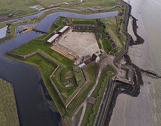
Tilbury Fort, also known historically as the Thermitage Bulwark and the West Tilbury Blockhouse, is an artillery fort on the north bank of the River Thames in England. The earliest version of the fort, comprising a small blockhouse with artillery covering the river, was constructed by King Henry VIII to protect London against attack from France as part of his Device programme. It was reinforced during the 1588 Spanish Armada invasion scare, after which it was reinforced with earthwork bastion, and Parliamentary forces used it to help secure the capital during the English Civil War of the 1640s. Following naval raids during the Anglo-Dutch Wars, the fort was enlarged by Sir Bernard de Gomme from 1670 onwards to form a star-shaped defensive work, with angular bastions, water-filled moats and two lines of guns facing onto the river.

Deal Castle is an artillery fort constructed by Henry VIII in Deal, Kent, between 1539 and 1540. It formed part of the King's Device programme to protect against invasion from France and the Holy Roman Empire, and defended the strategically important Downs anchorage off the English coast. Comprising a keep with six inner and outer bastions, the moated stone castle covered 0.85 acres (0.34 ha) and had sixty-six firing positions for artillery. It cost the Crown a total of £27,092 to build the three castles of Deal, Sandown and Walmer, which lay adjacent to one another along the coast and were connected by earthwork defences. The original invasion threat passed but, during the Second English Civil War of 1648–49, Deal was seized by pro-Royalist insurgents and was only retaken by Parliamentary forces after several months' fighting.

The Device Forts, also known as Henrician castles and blockhouses, were a series of artillery fortifications built to defend the coast of England and Wales by Henry VIII. Traditionally, the Crown had left coastal defences in the hands of local lords and communities but the threat of French and Spanish invasion led the King to issue an order, called a "device", for a major programme of work between 1539 and 1547. The fortifications ranged from large stone castles positioned to protect the Downs anchorage in Kent, to small blockhouses overlooking the entrance to Milford Haven in Pembrokeshire, and earthwork bulwarks along the Essex coast. Some forts operated independently, others were designed to be mutually reinforcing. The Device programme was hugely expensive, costing a total of £376,000 ; much of this was raised from the proceeds of the Dissolution of the Monasteries a few years before.

Hurst Castle is an artillery fort established by Henry VIII on the Hurst Spit in Hampshire, England, between 1541 and 1544. It formed part of the king's Device Forts coastal protection programme against invasion from France and the Holy Roman Empire, and defended the western entrance to the Solent waterway. The early castle had a central keep and three bastions, and in 1547 was equipped with 26 guns. It was expensive to operate due to its size, but it formed one of the most powerful forts along the coast. During the English Civil War of the 1640s, Hurst was held by Parliament and was used briefly to detain King Charles I before his execution in 1649. It continued in use during the 18th century but fell into disrepair, the spit being frequented by smugglers.

Yarmouth Castle is an artillery fort built by Henry VIII in 1547 to protect Yarmouth Harbour on the Isle of Wight from the threat of French attack. Just under 100 feet (30 m) across, the square castle was initially equipped with 15 artillery guns and a garrison of 20 men. It featured an Italianate "arrow-head" bastion on its landward side; this was very different in style from the earlier circular bastions used in the Device Forts built by Henry and was the first of its kind to be constructed in England.
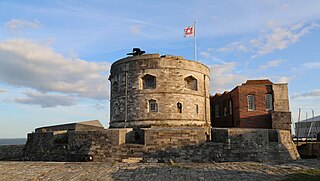
Calshot Castle is an artillery fort constructed by Henry VIII on the Calshot Spit, Hampshire, England, between 1539 and 1540. It formed part of the King's Device programme to protect against invasion from France and the Holy Roman Empire and defend Southampton Water as it met the Solent. The castle had a keep at its centre, surrounded by a curtain wall and a moat. Initially heavily armed, it had a garrison of 16 men and as many as 36 artillery guns. The castle continued in use for many years, surviving the English Civil War intact and being extensively modernised in the 1770s. During the 19th century, Calshot Castle was used by the coastguard as a base for combating smuggling. In 1894, however, fresh fears of a French invasion led to it being brought back into use as an artillery fort: a large coastal battery was constructed alongside the older castle and a boom built across Southampton Water, controlled from the castle.

Portland Castle is an artillery fort constructed by Henry VIII on the Isle of Portland, Dorset, between 1539 and 1541. It formed part of the King's Device programme to protect against invasion from France and the Holy Roman Empire, and defended the Portland Roads anchorage. The fan-shaped castle was built from Portland stone, with a curved central tower and a gun battery, flanked by two angular wings. Shortly after its construction it was armed with eleven artillery pieces, intended for use against enemy shipping, operating in partnership with its sister castle of Sandsfoot on the other side of the anchorage. During the English Civil War, Portland was taken by the Royalist supporters of King Charles I, and then survived two sieges before finally surrendering to Parliament in 1646.

Sandsfoot Castle, also known historically as Weymouth Castle, is an artillery fort constructed by Henry VIII near Weymouth, Dorset. It formed part of the King's Device programme to protect against invasion from France and the Holy Roman Empire, and defended the Weymouth Bay anchorage. The stone castle had an octagonal gun platform, linked to a residential blockhouse, and was completed by 1542 at a cost of £3,887. Earthwork defences were built around the landward side of the castle, probably in 1623. Sandsfoot saw service during the English Civil War, when it was held by Parliament and Royalists in turn during the conflict. It survived the interregnum but, following Charles II's restoration to the throne, the fortress was withdrawn from military use in 1665.
Pendennis Castle is an artillery fort constructed by Henry VIII near Falmouth, Cornwall, England between 1540 and 1542. It formed part of the King's Device programme to protect against invasion from France and the Holy Roman Empire, and defended the Carrick Roads waterway at the mouth of the River Fal. The original, circular keep and gun platform was expanded at the end of the century to cope with the increasing Spanish threat, with a ring of extensive stone ramparts and bastions built around the older castle. Pendennis saw service during the English Civil War, when it was held by the Royalists, and was only taken by Parliament after a long siege in 1646. It survived the interregnum and Charles II renovated the fortress after his restoration to the throne in 1660.
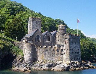
Dartmouth Castle is an artillery fort, built to protect Dartmouth harbour in Devon, England. The earliest parts of the castle date from the 1380s, when, in response to the threat of a French attack, the civic authorities created a small enclosure castle overlooking the mouth of the Dart estuary. This was intended to engage enemy ships with catapults and possibly early cannon, and incorporated the local chapel of Saint Petroc within its walls. At the end of the 15th century, the castle was expanded with an artillery tower and an iron chain which could be stretched across the harbour to a tower at Godmerock; this addition formed the oldest known purpose-built coast artillery fort in Britain. Further gun batteries were added during the French invasion scare of the 1540s.

St Mawes Castle is an artillery fort constructed by Henry VIII near Falmouth, Cornwall, between 1540 and 1542. It formed part of the King's Device programme to protect against invasion from France and the Holy Roman Empire, and defended the Carrick Roads waterway at the mouth of the River Fal. The castle was built under the direction of Thomas Treffry to a clover leaf design, with a four-storey central tower and three protruding, round bastions that formed gun platforms. It was initially armed with 19 artillery pieces, intended for use against enemy shipping, operating in partnership with its sister castle of Pendennis on the other side of the estuary. During the English Civil War, St Mawes was held by Royalist supporters of King Charles I, but surrendered to a Parliamentary army in 1646 in the final phase of the conflict.

Bayard's Cove Fort, also known historically as Berescove or Bearscore Castle, is an English 16th-century artillery blockhouse, built to defend the harbour entrance at Dartmouth in Devon. Constructed in the early part of the century, it had eleven gunports for heavy artillery and was intended to engage enemy vessels that broke past the external defences of the Dartmouth and Kingswear castles. It remained armed during the English Civil War, but was neglected in the 18th century and used for storage. The fort was restored in the late 19th century and is now managed by English Heritage and open to visitors.

Hull Castle was an artillery fort in Kingston upon Hull in England. Together with two supporting blockhouses, it defended the eastern side of the River Hull, and was constructed by King Henry VIII to protect against attack from France as part of his Device programme in 1542. The castle had two large, curved bastions and a rectangular keep at its centre; the blockhouses to the north and south had three curved bastions supporting guns, and a curtain wall and moat linked the blockhouses and castle. The construction project used material from recently dissolved monasteries, and cost £21,056. The town took over responsibility for these defences in 1553, leading to a long running dispute with the Crown as to whether the civic authorities were fulfilling their responsibilities to maintain them.

Cowes Castle, also known as West Cowes Castle, is a Device Fort in Cowes on the Isle of Wight. Originally built by Henry VIII in 1539 to protect England against the threat of invasion from France and the Holy Roman Empire, it comprised a circular bastion, flanking wings and a keep, and in 1547 it housed 17 pieces of artillery. With its companion fortification at East Cowes, the castle overlooked the entrance to the River Medina, an important anchorage. The invasion threat passed but the fortification continued in use until the middle of the 19th century, very briefly seeing action in 1642 during the English Civil War.

St Andrew's Castle was an artillery fort constructed by Henry VIII near Hamble-le-Rice, Hampshire, between 1542 and 1543. It formed part of the King's Device programme to protect against invasion from France and the Holy Roman Empire, and defended Southampton Water near the Solent. St Andrew's comprised a keep and a gun platform, protected by a moat. The castle was decommissioned in 1642 during the English Civil War and has been largely destroyed through coastal erosion.

The East and West Blockhouses were Device Forts built by King Henry VIII in 1539 to protect the harbour of Milford Haven in Wales. The two blockhouses were positioned on either side of the Milford Haven Waterway in the villages of Angle and Dale respectively, overlooking the sea. The East Blockhouse was never completed, but the remains were reused as a defensive site in the Second World War. The West Blockhouse was described by contemporaries as forming a round tower with gunports, but it was demolished when West Blockhouse Fort was built on the same site in the 19th century.
Milton Blockhouse was an artillery fortification constructed as part of Henry VIII's Device plan of 1539, in response to fears of an imminent invasion of England. It was built at Milton, near Gravesend in Kent at a strategic point along the River Thames, and was operational by 1540. Equipped with 30 pieces of artillery and a garrison of 12 men and a captain, it was probably a two-storey, D-shaped building, designed to prevent enemy ships from progressing further up the river or landing an invasion force. It was stripped of its artillery in 1553 and was demolished between 1557 and 1558; nothing remains of the building above ground, although archaeological investigations in the 1970s uncovered parts of the blockhouse's foundations.

Gravesend Blockhouse was an artillery fortification constructed as part of Henry VIII's Device plan of 1539, in response to fears of an imminent invasion of England by European countries. It was built at Gravesend in Kent at a strategic point along the River Thames and was operational by 1540. A two-storey, D-shaped building built from brick and stone, it had a circular bastion overlooking the river and gun platforms extending out to the east and west. It functioned in conjunction with Tilbury Fort on the other side of the river, and was repaired in 1588 to deal with the threat of Spanish invasion, and again in 1667 when the Dutch navy raided the Thames. A 1778 report recommended alterations to the blockhouse and its defences, leading to the remodelling of the gun platforms and the construction of the new, larger New Tavern Fort alongside it. In the 1830s the government decided to rely entirely on the newer fort and the old blockhouse was demolished in 1844. Its remains were uncovered in archaeological excavations between 1975 and 1976.
Mersea Fort, also known as Cudmore Grove Blockhouse, was an artillery fort established by Henry VIII on the East Mersea coast in 1543. It formed part of the King's Device programme to protect against invasion from France and the Holy Roman Empire, and defended the River Colne that led to the town of Colchester. It was triangular in shape, with earthwork walls and three bastions to hold artillery. It was demobilised in 1552, but was brought back into use several times over the next century and saw service during the Second English Civil War of 1648. The fort hosted an admiralty court to oversea the local oyster trade, until the dilapidation of the site forced the court to move to the Moot Hall in Colchester in the middle of the 18th century. A new gun battery was built at the fort during the Napoleonic Wars, but the fortification then fell into decline and was extensively damaged by the construction of a sea wall along the coast. The remains of the earthworks were excavated by archaeologists between 2002 and 2003.


