
The Isle of Wight is an island, English county and unitary authority in the English Channel, 2 to 5 miles off the coast of Hampshire, across the Solent. It is the largest and second-most populous island in England. Referred to as "The Island" by residents, the Isle of Wight has resorts that have been popular holiday destinations since Victorian times. It is known for its mild climate, coastal scenery, and verdant landscape of fields, downland, and chines. The island is historically part of Hampshire. The island is designated a UNESCO Biosphere Reserve. With a land area of 380 km2 (150 sq mi), it is about half the size of Singapore.
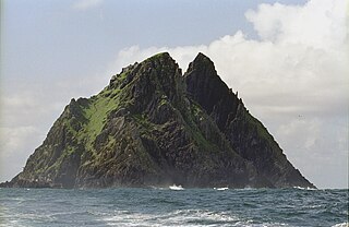
Skellig Michael, also called Great Skellig, is a twin-pinnacled crag 11.6 kilometres (7.2 mi) west of the Iveragh Peninsula in County Kerry, Ireland. The island is named after the archangel Michael, with "Skellig" derived from the Irish language word sceilig, meaning a splinter of stone. Its twin island, Little Skellig, is smaller and inaccessible. The two islands rose c. 374–360 million years ago during a period of mountain formation, along with the MacGillycuddy's Reeks mountain range. Later, they were separated from the mainland by rising water levels.

Ventnor is a seaside resort town and civil parish established in the Victorian era on the southeast coast of the Isle of Wight, England, eleven miles (18 km) from Newport. It is situated south of St Boniface Down, and built on steep slopes leading down to the sea. The higher part is referred to as Upper Ventnor ; the lower part, where most amenities are located, is known as Ventnor. Ventnor is sometimes taken to include the nearby and older settlements of St Lawrence and Bonchurch, which are covered by its town council. The population is 5,567 according to the 2021 Census

Niton is a village and former civil parish, now in the parish of Niton and Whitwell, on the Isle of Wight, England. It is west of Ventnor, with a population of 2,082. It has two pubs, several churches, a pottery workshop/shop, a pharmacy, a busy volunteer-run library, a medical centre and two local shops including a post office. The post office includes a pub and café that serves as a local meeting place. The village also offers a primary school with a co-located pre-school and nursery.

The Isle of Wight is rich in historical and archaeological sites, from prehistoric fossil beds with dinosaur remains, to dwellings and artefacts dating back to the Bronze Age, Iron Age, and Roman periods.

Chale is a village and civil parish on the Isle of Wight of England, in the United Kingdom. It is located three kilometres from Niton in the south of the Island in the area known as the Back of the Wight. The village of Chale lies at the foot of St. Catherine's Down.

St Catherine's Point is the southernmost point on the Isle of Wight. It is close to the village of Niton and the point where the Back of the Wight changes to the Undercliff of Ventnor.

St. Catherine's Down is a chalk down on the Isle of Wight, located near St Catherine's Point, the southernmost point on the island. The Down rises to 240 metres at its highest point, between the towns of Niton and Chale. Upon the hill is St. Catherine's Oratory, which is a stone lighthouse built in the 14th century by Walter De Godeton. It is the second oldest, and only surviving, medieval lighthouse in the British Islands: only the Roman lighthouse at Dover is older.

St Catherine's Chapel is a small chapel situated on a hill above the village of Abbotsbury in Dorset, England. It is dedicated to Saint Catherine. It is now in the guardianship of English Heritage and became a Grade I listed building in 1956. The chapel is also scheduled together with the field systems and quarries on the hill.
SS Varvassi is a wrecked ship just off the Needles lighthouse, which is at the western end of the Isle of Wight. The ship crashed about 150 metres west of the lighthouse. The Isle of Wight is off the South coast of England, near Southampton.
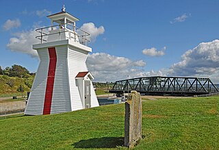
A Pepperpot or Salt Shaker lighthouse is a type of small lighthouse that has an architectural style similar to a scaled up salt or pepper shaker. These lighthouses feature a square tapered base with a single gallery and a square lantern. They are usually shingled in wood and painted white; the lantern and trim are red. Many such lighthouses still exist across Canada, especially in the Maritime provinces.
Egypt Point is the northernmost point of the island county of the Isle of Wight off the south coast of England, and was one of Queen Victoria's favoured places during her time on the island. According to the Post Office at the 2011 Census the point population was included in the civil parish of Northwood, Isle of Wight.
Puckaster is a hamlet on the Isle of Wight, England. Puckaster is on the southern coast of the Isle of Wight, south of Niton, between St. Catherine's Point and Binnel.

Whale Chine is a geological feature near Chale on the south-west coast of the Isle of Wight, England. One of a number of such chines on the island created by stream erosion of soft Cretaceous rocks, it is a narrow and steep coastal ravine dropping 140 feet through Lower Greensand rocks from clifftop farmland to Chale Bay.
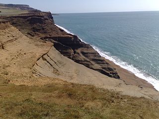
Ladder Chine is a geological feature on the south west coast of the Isle of Wight, England. It is west of the village of Chale. It is a sandy coastal ravine, one of a number of such chines on the island created by stream erosion of soft Cretaceous rocks. It leads from the 190 foot high clifftop to a knickpoint approximately halfway down the cliff face above Chale Bay beach.

Chale Bay is a bay on the south-west coast of the Isle of Wight, England. It lies to the west of the village of Chale from which it takes its name. It faces south-west towards the English Channel, its shoreline is 3+1⁄4 miles (5.2 km) in length and is gently curving. It stretches from Artherfield Point in the north-west to Rocken End in the south-east.

Freshwater Redoubt, also known as Fort Redoubt, is an old Palmerston fort built in Freshwater Bay on the western end of the Isle of Wight. Construction work for the fort began in 1855 and was completed in 1856. It was finally sold in 1928 and has now been converted into a private residence.

Back of the Wight is an area on the Isle of Wight in England. The area has a distinct historical and social background, and is geographically isolated by the chalk hills, immediately to the North, as well as poor public transport infrastructure. Primarily agricultural, the Back of the Wight is made up of small villages spread out along the coast, including Brighstone, Shorwell and Mottistone.

St Catherine's Lighthouse is a lighthouse located at St Catherine's Point at the southern tip of the Isle of Wight. It is one of the oldest lighthouse locations in Great Britain.


