
County Sligo is a county in Ireland. It is in the Northern and Western Region and is part of the province of Connacht. Sligo is the administrative capital and largest town in the county. Sligo County Council is the local authority for the county. The population of the county was 69,819 at the 2022 census. It is noted for Benbulben Mountain, one of Ireland's most distinctive natural landmarks.

Castlepollard is a village in north County Westmeath, Republic of Ireland. It lies west of Lough Lene and northeast of Lough Derravaragh and Mullingar.

Kinvara or Kinvarra is a sea port village in the southwest of County Galway, Ireland. It is located in the civil parish of Kinvarradoorus in the north of the barony of Kiltartan. Kinvarra is also an electoral division.

Enniscrone – also spelt Inniscrone and officially named Inishcrone – is a small seaside town in County Sligo, Ireland. Its sandy beach, tourist campsite, and golf course all attract visitors. As of the 2016 census, the town had a population of 1,156 people.

Ballintra is a village in the parish of Drumholm in the south of County Donegal, Ireland, just off the N15 road between Donegal town and Ballyshannon. Ballintra lies on the northern bank of the Blackwater river. The river rises in the hills that lie inland from the town, and flows through a number of small lakes before spilling over a small waterfall in a gorge behind the village.

Ballysadare, locally also Ballisodare, is a town in County Sligo, Ireland. It is about 7 kilometres south of Sligo town. The town developed on an important crossing of the Owenmore River.

Drumcliff or Drumcliffe is a village in County Sligo, Ireland. It is 8 km north of Sligo town on the N15 road on a low gravel ridge between the mountain of Ben Bulben and Drumcliff bay. It is on the Drumcliff river, originally called the "Codnach", which drains Glencar Lake. Drumcliff is the resting place of the Irish poet W. B. Yeats.

Easky or Easkey is a village in County Sligo, Ireland. It is on the Atlantic coast, 26 miles (42 km) from Sligo and 15 miles (24 km) from Ballina, County Mayo. The village name derives from the Irish language term for fish ("iasc") and "Iascaigh" literally means "abounding in fish", due to the Easky River that lies adjacent to the village itself. Easky, as a parish, was originally called "Imleach Iseal". The area is a tourist destination on account of its scenery and water sports. Easky is a designated area on Ireland's Wild Atlantic Way tourist route.

Riverstown, historically called Ballyederdaowen, is a village in County Sligo, Ireland. Known for its musical tradition it is located at a bridging point of the River Unshin (Arrow), 17.2 km south of Sligo town and 4 km east of the N4 road.

The villages of Killucan and Rathwire are co-located in the east of County Westmeath, Ireland. They have a combined population of 1,370 according to the 2016 census. Killucan is on the R156 road about 15 km (9.3 mi) from Mullingar and 60 km (37 mi) from Dublin.

Newcestown is a small village located 35 km from the city of Cork in the western part of County Cork, Ireland. It is a village with a church, a school, a pub and GAA club. Newcestown is part of the Dáil constituency of Cork North-West.

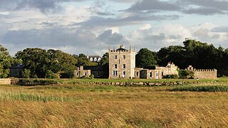
Lissadell House is a neo-classical Greek revivalist style country house in County Sligo, Ireland.
The United Dioceses of Kilmore, Elphin and Ardagh is a diocese of the Church of Ireland located in central Ireland. It is in the ecclesiastical province of Armagh.
Kilcolgan, is a village on the mouth of the Kilcolgan River at Dunkellin Bay in County Galway, Ireland. The settlement is at the junction of the N67 and R458 roads, which lies between Gort and Clarinbridge. The village is near the site of the Galway Bay drowning tragedy. Kilcolgan was designated as a census town by the Central Statistics Office for the first time in the 2016 census, at which time it had a population of 141 people.

Street or Streete is a village and parish in County Westmeath, Ireland. It lies on the regional road between Lismacaffery and Rathowen. Its Irish name was historically anglicised as Straid or Strade.

Dunkerrin is a small village in County Offaly, Ireland, just south of Roscrea and near the County Tipperary border. It is on the R445 road which was once the main road from Dublin to Limerick. Dunkerrin is now bypassed by the M7, the nearest access is junction 23 at Moneygall.

Cairbre Drom Cliabh was an Irish túath in the ancient confederation of Íochtar Connacht, now County Sligo in the west of Ireland. It is now represented by the barony of Carbury. Also known as Cairbre na Catha. It existed from at least the 6th century to the 16th century AD.
Killenard is a village in County Laois, Ireland. It lies in the historic barony of Portnahinch and within the administrative area of Laois County Council.
Drumcliff Monastery was located in Cairbre Drom Cliabh, now County Sligo, five miles north of the modern town of Sligo. The site consists of the remains of a round tower and several high crosses, including one outstanding example. It is currently also the site of a Church of Ireland parish church and a graveyard. It is the burial place of the poet William Butler Yeats. Founded in the 6th century by Saint Colmcille, he is said to have declared in a later literary fragment:
Beloved to my heart also in the West— Drumcliffe at Culcinne's strand.

Curry is a village and townland in County Sligo, Ireland. The townland has an area of approximately 3.9 square kilometres (1.5 sq mi), and had a population of 148 people as of the 2011 census.

