St Germain's Churchyard

Last updated

St Germain's Churchyard
St Germain's church - geograph.org.uk - 795347.jpg
St Germain's church tower
St Germain's Churchyard
Details
Closed1956
Location
CountryEngland
Coordinates 54°35′38″N1°00′40″W / 54.594°N 1.011°W / 54.594; -1.011
Website Friends of St Germains
Find a Grave St Germain's Churchyard

St Germain's Churchyard is a large cemetery overlooking the North Sea at Marske-by-the-Sea, North Yorkshire, England. Its church tower is a grade II listed structure at the midpoint to the yard and a landmark for sailors out on the sea. It is a remnant of a demolished church, services at St Germain's were replaced in 1876 by St Mark's.

Contents

History

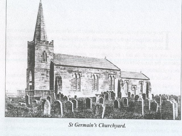
At least two, possibly three churches are believed to have been erected on the site, with the church being dedicated to St Germain. [1] [note 1] The land for building the church upon was given to the village by Earl Tostig. [4] According to contemporary records, the church was consecrated by Egelric, who was bishop of Durham between 1042 and 1056. [3] In the early 19th century, the Church of St Germain was in a ruinous state, and so was rebuilt between 1820 and 1821, [5] with the rebuilding seeing all of the church bar the tower destroyed by gunpowder. [6] The rebuilt church continued to serve the village until the newer parish church of St Marks, was built in 1867. [7] The village is believed to have migrated westwards in Medieval times, leaving the church isolated from the rest of the village to the east, on the clifftop. [8] The creation of the newer and larger parish church, was driven by an influx of workers who had come to work in the ironstone industry, which had developed in the area from the 1850s. [9] At the same time as the church was abandoned, the newer Parish of Redcar was created from parts of the parishes of Marske-by-the-Sea and Upleatham. [10]

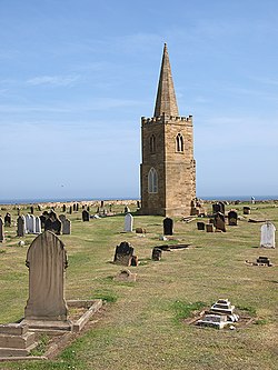
The old church of St Germain's, was demolished in 1955, but the church tower was left standing on its own in the churchyard. [11] The tower was a prominent local landmark used by sailors on the North Sea for navigation. [12] [13] The bell in the tower, which was over 550 years old, was placed in the tower of the St Mark's. [14]

The graveyard contains 17 Commonwealth War Graves from both the First and Second World Wars including those from the nearby First World War aerodrome, which was just to the west of the graveyard. [15] [16] Captain Cook's father, also himself called James Cook, was buried in the graveyard at St Germain's in 1779, two months after his son's death. [17] He was unaware that his son had been killed in Hawaii. [18] At least 50 ironstone miners, killed between 1860 and 1920 at Upleatham Mine, are buried at St Germains. [19] The graveyard also contains the bodies of sailors and passengers who drowned at sea; often on Redcar Rocks, which the tower overlooks. [20]

The graveyard continued to be used for burials even after the newer church was erected in 1867, [21] and was eventually closed in 1956, but smaller plots for ashes have been installed around the edges since closure to interments. [22] The tower was grade II listed in 1967. [23]

Zetland family vault

Underneath the chancel was the vault of the Zetland family, who resided mainly at nearby Upleatham Hall. Several family members were buried in the vault;

Notes

  1. Sometimes misspelt as St German. [2] St Germain was one of the Parisian bishops who visited Britain to denounce the Pelagian Heresy. [3]

Related Research Articles

<span class="mw-page-title-main">Eston</span> Area of Redcar and Cleveland, North Yorkshire, England

Eston is an area of Redcar and Cleveland in North Yorkshire, England. The local authority ward covering the area had a population of 7,005 at the 2011 census. It is part of Greater Eston, which includes the outlying settlements of Grangetown, Normanby, South Bank, Teesville and part of Ormesby.

<span class="mw-page-title-main">North Riding of Yorkshire</span> Third of a historic county in England

The North Riding of Yorkshire is a subdivision of Yorkshire, England, alongside York, the East Riding and West Riding. The riding's highest point is at Mickle Fell at 2,585 ft (788 m).

<span class="mw-page-title-main">Redcar</span> Town in North Yorkshire, England

Redcar is a seaside town on the Yorkshire Coast in the Redcar and Cleveland unitary authority in the county of North Yorkshire, England. It is located 7 miles (11 km) east of Middlesbrough.

<span class="mw-page-title-main">Loftus, North Yorkshire</span> Town and civil parish in North Yorkshire, England

Loftus is a market town and civil parish in the Redcar and Cleveland borough of North Yorkshire, England. The town is located north of the North York Moors and sits between Whitby and Skelton-in-Cleveland.

<span class="mw-page-title-main">Marske-by-the-Sea</span> Village in North Yorkshire, England

Marske-by-the-Sea is a village in the unitary authority of Redcar and Cleveland and the ceremonial county of North Yorkshire, England. It is located on the coast, between the seaside resorts of Redcar and Saltburn-by-the-Sea, although it is not itself a seaside resort. Marske is in the civil parish of Saltburn, Marske and New Marske and comprises the wards of Longbeck and St Germains.

<span class="mw-page-title-main">Normanby, Redcar and Cleveland</span> Area of Redcar and Cleveland, North Yorkshire, England

Normanby is an area in the borough of Redcar and Cleveland, North Yorkshire, England. A ward covering the area had a population of 6,930 at the 2011 census. It is part of Greater Eston, which includes the area and the outlying settlements of Eston, Grangetown, South Bank, Teesville and part of Ormesby.

<span class="mw-page-title-main">Brotton</span> Village in North Yorkshire, England

Brotton is a village in the civil parish of Skelton and Brotton, in the Redcar and Cleveland district, in the ceremonial county of North Yorkshire, England It is situated approximately 2.5 miles (4 km) south-east of Saltburn-by-the-Sea, 9 miles from Redcar, 12 miles (19 km) east of Middlesbrough and 14 miles (23 km) north-west of Whitby.

<span class="mw-page-title-main">Saltburn, Marske and New Marske</span> Civil parish in North Yorkshire, England

Saltburn, Marske and New Marske is a civil parish in the Redcar and Cleveland district, in the ceremonial county of North Yorkshire, England. According to the 2001 census it had a population of 18,325 increasing to 19,134 at the 2011 census. As its name suggests, the parish includes Saltburn, Marske-by-the-Sea and New Marske. It borders the parishes of Skelton and Brotton, Guisborough and the unparished area of Redcar.

<span class="mw-page-title-main">Easington, North Yorkshire</span> Village in North Yorkshire, England

Easington is a village in the civil parish of Loftus, in the Redcar and Cleveland district, in the ceremonial county of North Yorkshire, England and is part of the North York Moors National Park. The village is situated on the A174 road, 1 mile (1.6 km) east of Loftus, 8 miles (13 km) east of Guisborough, and 10 miles (16 km) north-west of Whitby. At the 2011 census, the village had a population of 923.

<span class="mw-page-title-main">Kilton, North Yorkshire</span> Village in the Borough of Redcar and Cleveland, England

Kilton is a village in the civil parish of Lockwood, in the borough of Redcar and Cleveland, in the ceremonial county of North Yorkshire, England.

<span class="mw-page-title-main">Kilton Thorpe</span> Village in North Yorkshire, England

Kilton Thorpe is a village in the borough of Redcar and Cleveland and the ceremonial county of North Yorkshire, England. Noted for evidence of early settlement. The outlines of an ancient village are visible in fields adjacent to the present village.

<span class="mw-page-title-main">Upleatham</span> Village in North Yorkshire, England

Upleatham is a village in the civil parish of Guisborough, in the unitary authority area of Redcar and Cleveland and the ceremonial county of North Yorkshire, England. The village was mentioned in the Domesday Book and the name derives from Old English and Old Norse as Upper Slope, in that it was further up the hill than Kirkleatham.

<span class="mw-page-title-main">Grangetown, North Yorkshire</span> Area of Redcar and Cleveland in North Yorkshire, England

Grangetown is an area in the borough of Redcar and Cleveland, North Yorkshire, England. The area is 3 miles (4.8 km) east of Middlesbrough and 4 miles (6.4 km) from south-west of Redcar.

<span class="mw-page-title-main">Lockwood, North Yorkshire</span> Civil parish in North Yorkshire, England

Lockwood is a civil parish in the unitary authority of Redcar and Cleveland with ceremonial association with North Yorkshire, England. The population of Lockwood ward in the Redcar and Cleveland Unitary authority taken at the 2011 census was 2,022.

<span class="mw-page-title-main">Church of St Oswald, Lythe</span> Anglican church in North Yorkshire, England

The Church of St Oswald, Lythe, is the parish church for the village of Lythe, 4 miles (6.4 km) west, north west of Whitby in North Yorkshire, England. The church is at the top of Lythe Bank and is just east of the village on the A174 road.

<span class="mw-page-title-main">Kettleness</span> Hamlet in North Yorkshire, England

Kettleness, is a hamlet in the Scarborough District of North Yorkshire, England. The settlement only consists of half-a-dozen houses, but up until the early 19th century, it was a much larger village. However, most of that village, which was on the headland, slipped into the sea as a result of instability caused by quarrying for the alum industry. Kettleness became a smaller settlement, with houses rebuilt slightly further inland.

North Skelton Mine was an ironstone mine in the village of North Skelton in North Yorkshire, England. The mine was the deepest of the ironstone mines in Cleveland and was also the last to close, which came in January 1964. Some buildings still exist on the surface as well as spoil heaps.

<span class="mw-page-title-main">Church of St Peter ad Vincula, Thornaby-on-Tees</span> Anglican church in North Yorkshire, England

The Church of St Peter ad Vincula, Thornaby, is an Anglican church in Thornaby, North Yorkshire, England. The structure, which is grade II* listed, is dated to the 12th century, replacing an earlier building on the same site. The church is noted for being the supposed baptismal location of Grace Pace, Captain Cook's mother.

<span class="mw-page-title-main">Marske Aerodrome</span> Former military aerodrome in Marske, North Yorkshire, England

Marske Aerodrome was a First World War-era airfield used by the Royal Flying Corps, and later by the Royal Air Force, between 1917 and 1920. The aerodrome was just to the west of the village of Marske-by-the-Sea in Yorkshire, England. Marske aerodrome hosted air gunnery schools and trained pilots in tactics and methods of aerial combat so that they could be deployed to the front. Marske is known for being the aerodrome where W. E. Johns, author of the Biggles books, undertook his training, as well as being noted for some of the flying instructors who were famous among the aircrew cadre.

<span class="mw-page-title-main">Hutton Village</span> Village in North Yorkshire, England

Hutton Village is a settlement in the Hutton Lowcross area of Guisborough in North Yorkshire, England. Whilst the area itself is mentioned in the Domesday Book, the village was built largely due to the development of the ironstone industry in the Cleveland Hills. The name Hutton Lowcross referred to the township in the area, whereas the settlement is now known as Hutton Village. The village is set in a narrow dale that carries Hutton Beck northwards towards Guisborough.

References

  1. Whellan, T (1859). History and topography of the city of York and the North Riding of Yorkshire; embracing a general review of the early history of Great Britain, and a general history and description of the County of York. Beverley: John Green. p. 805. OCLC   963782088.
  2. Liber Ecclesiasticus. An authentic statement of the revenues of the Established Church compiled from the report of the Commissioners appointed to inquire into the Revenues and Patronage of the established Church in England and Wales. London: Hamilton, Adams & Co. 1835. p. 133. OCLC   1064949647.
  3. 1 2 McAll Fallow 1911, p. 233.
  4. Horton, Minnie C. (1979). The story of Cleveland : history, anecdote, and legend. Middlesbrough: Cleveland County Libraries. p. 326. ISBN   0904784096.
  5. "Parishes: Marske | British History Online". www.british-history.ac.uk. Retrieved 27 January 2021.
  6. "At Your Service: Beggaring belief". The Northern Echo. 2003. Retrieved 1 July 2021.
  7. Historic England. "Church of St Mark (Grade II) (1387546)". National Heritage List for England . Retrieved 28 January 2021.
  8. MCAA 2011, p. 34.
  9. MCAA 2011, p. 35.
  10. "Genuki: REDCAR: Geographical and Historical information from the year 1890., Yorkshire (North Riding)". www.genuki.org.uk. Retrieved 2 July 2021.
  11. "Stonemasons repair old church tower". Evening Gazette. 12 July 2019. p. 21. ISSN   2056-6131.
  12. McAll Fallow 1911, p. 234.
  13. "Genuki: Marske By The Sea, Yorkshire (North Riding)". www.genuki.org.uk. Retrieved 2 July 2021.
  14. "Take in the views from 86ft". Evening Gazette. 2 August 2016. p. 19. ISSN   2056-6131.
  15. "Marske-in-Cleveland St Germain churchyard". www.cwgc.org. Retrieved 27 January 2021.
  16. "Marske I - Airfields of Britain Conservation Trust UK". www.abct.org.uk. Retrieved 27 January 2021.
  17. Howse, Geoffrey (2010). The little book of Yorkshire. Stroud: History Press. p. 110. ISBN   978-0-7524-6267-7.
  18. Fisher, Stuart G. (2019). "5: Cleveland". Coastal Britain : England & Wales : celebrating the history, heritage and wildlife of Britain's shores. London: Bloomsbury. p. 25. ISBN   9781472958730.
  19. "Durham Mining Museum - Upleatham (Ironstone)". www.dmm.org.uk. Retrieved 2 July 2021.
  20. Robertson, Kirsty (18 February 2019). "Plea to help mark tragedy". Press & Journal. p. 23. ISSN   2632-1165.
  21. "Genuki: MARSKE BY THE SEA: Geographical and Historical information from the year 1890., Yorkshire (North Riding)". www.genuki.org.uk. Retrieved 2 July 2021.
  22. Robson, Dave (1 April 2017). "Unholy row after order to clear personal mementos[sic] from graves". TeessideLive. Retrieved 27 January 2021.
  23. Historic England. "Old Church of St Germain (Grade II) (1387566)". National Heritage List for England . Retrieved 2 July 2021.
  24. 1 2 "CHARACTER – Death of the Earl of Zetland. Thomas Dundas | Redcar.org | Past & Present". www.redcar.org. Retrieved 2 July 2021.
  25. "Religious Intelligence". Caledonian Mercury. No. 23929. Column F. 10 March 1866. p. 3.

Sources