
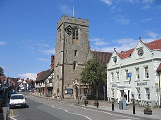
Warwick is a market town, civil parish and the county town of Warwickshire in the Warwick District in England, adjacent to the River Avon. It is 9 miles (14 km) south of Coventry, and 19 miles (31 km) south-east of Birmingham. It is adjoined with Leamington Spa and Whitnash.

Willoughby is a village and civil parish about 5 miles (8 km) south of Rugby, Warwickshire, England. The village is about 4.5 miles (7 km) northwest of Daventry in neighbouring Northamptonshire and the eastern boundary of the parish forms part of the county boundary.

The Royal Warwickshire Regiment, previously titled the 6th Regiment of Foot, was a line infantry regiment of the British Army in continuous existence for 283 years. The regiment saw service in many conflicts and wars, including the Second Boer War and both the First and Second World Wars. On 1 May 1963, the regiment was re-titled, for the final time, as the Royal Warwickshire Fusiliers and became part of the Fusilier Brigade.
Henley-in-Arden is a market town and civil parish in the Stratford-on-Avon District in Warwickshire, England. The town takes its last name from the former Forest of Arden. Henley is known for its variety of historic buildings, some of which date back to medieval times, and its wide variety of preserved architectural styles. The one-mile-long (1.6 km) High Street is a conservation area.

Bordesley Abbey was a 12th-century Cistercian abbey near the town of Redditch, in Worcestershire, England.

Baginton is a village and civil parish in the Warwick district of Warwickshire, England, and has a common border with the City of Coventry / West Midlands county. With a population of 801, Baginton village is 4 miles (6.4 km) south of central Coventry, 4.5 miles (7.2 km) northeast of Kenilworth and 7 miles (11 km) north of Leamington Spa. The population had reduced slightly to 755 at the 2011 Census. The Lucy Price playing field is situated centrally in the village.

Beaudesert is a village, civil parish and former manor in the Stratford-on-Avon district of Warwickshire, England, immediately east across the River Alne to the east of Henley-in-Arden, to which it is closely associated and shares a joint parish council with. The main village, consisting of the church and a single short street of houses, stands close to the river and directly opposite Henley Church. Behind the village to the east rises the hill, locally known as 'The Mount', crowned with the earthwork remains of Beaudesert Castle of the De Montforts. According to the 2001 Census it had a population of 919, increasing to 990 at the 2011 Census.
Budbrooke is a village and civil parish in the Warwick district of Warwickshire, England. It is 3 miles west of Warwick and according to the 2001 census the parish had a population of 2,319, reducing to 1,863 at the 2011 Census. Most of the population of Budbrooke live in Hampton Magna, a housing estate built in the late 1960s, with other smaller settlements in Budbrooke Village and Hampton on the Hill.

Compton Verney is a parish and historic manor in the county of Warwickshire, England. The population taken at the 2011 census was 119. The surviving manor house is the Georgian mansion Compton Verney House.

Sambourne, formerly spelled Sambourn, is a village and civil parish 1.5 miles (2.4 km) north-west of Coughton, 4.5 miles (7.2 km) south of Redditch, 12 miles (19 km) north-west of Stratford-upon-Avon and 20 miles (32 km) west of Warwick in the county of Warwickshire, England. It is situated on sloping ground rising westwards to about 500 feet near the ancient Ridge Way, and forms part of the county boundary with Worcestershire. The village itself is centred round a small triangular green at the junction of four roads and contains several timber-framed buildings of 17th century date. By a designation of 22 July 1991 much of the central area became a conservation area.

Temple Grafton is a village and civil parish in the Stratford-on-Avon district of Warwickshire, England, situated about 4 miles (6.4 km) east of Alcester and 14 miles (23 km) west of the county town of Warwick. The place name is misleading, the Knights Templar never having any association with the place but owing to a naming error made in the time of Henry VIII the mistake has been perpetuated. During the reign of Richard I the estate in fact belonged to the Knights Hospitaller. During the reign of Edward III in 1347 the village was recorded as Grafton Superior while neighbouring Ardens Grafton was named Inferior.

Spernall is a remote village 4 miles (6.4 km) north of Alcester in the parish of Oldberrow, Morton Bagot, and Spernall, in the Stratford-on-Avon District of Warwickshire, England. In the 2001 Census it had a population of 153. It is situated on the banks of the small River Arrow, the name meaning Spera's border. Early forms of the name are Spernore. and Spernoure in the 1327 Subsidy Roll. The village consists only of the church and rectory and a few scattered farms and cottages. At some time between 1195 and 1361 the parish was largely depopulated by pestilence, so that many of the villein tenements, which had hitherto accounted for almost the whole population, came into the hands of freemen. This may well refer to the Black Death; the priest at Spernall, Nicholas atte Yate, died in 1349 and there was another institution in 1351. In the 17th century the population seems to have mainly consisted of substantial farmers, for in 1625 it is described as a place with 'few or no poor at all in it and many wealthy inhabitants', and the Hearth Tax returns (1662–74) show the high average of about 2.5 hearths per house. By 1696, there were only two yeomen with an estate of £10 a year or more.

Coughton is a small village located between Studley 2.4 miles (4 km) to the North and Alcester, 2 miles (3 km) to the South, in the county of Warwickshire, England. The village lies 19.3 miles (31 km) from Birmingham on the Birmingham–Alcester A435 road, which here follows the line of the Roman road Icknield Street. The village mainly consists of a number of houses on Sambourne Lane, Coughton Lane and farms and is primarily noted as being the location of the National Trust property, Coughton Court, which lies 400 yards to the east of the A435. The population according to the 2001 Census was 139, increasing to 157 in the 2011 Census.
Horeston Grange is a suburban area of Nuneaton, Warwickshire in England.
Morton Bagot is a small village in the Stratford-on-Avon District of Warwickshire, England. It lies about 1.5 miles (2 km) east of the Birmingham-Alcester road, the modern A435 and Roman road Ryknild Street, 6.5 miles (10 km) north of Alcester, 9.5 miles (15 km) from Stratford-upon-Avon and 12 miles from Warwick, across the valley of a small brook, flowing south-east to join the River Arrow.

Monks Kirby Priory was a Benedictine priory established in 1077 in Monks Kirby, Warwickshire, England. The priory was suppressed in 1415 when its estates and revenues were given to the Carthusian priory of Axholme in Lincolnshire, in whose possession they continued until the Reformation. Remains of the priory form part of Monks Kirby village church today.

The buildings known as Whitefriars are the surviving fragments of a Carmelite friary founded in 1342 in Coventry, England. All that remains are the eastern cloister walk, a postern gateway in Much Park Street and the foundations of the friary church. It was initially home to a friary until the dissolution of the monasteries. During the 16th century it was owned by John Hales and served as King Henry VIII School, Coventry, before the school moved to St John's Hospital, Coventry. It was home to a workhouse during the 19th century. The buildings are currently used by Herbert Art Gallery and Museum, Coventry.
The remaining ruins of St Michael's Leper Hospital, a mediaeval hospital, lie in a patch of scrubland in the Saltisford area in the north of the town of Warwick, England, and are of the last remaining leper hospital in England. The hospital, which was founded by Roger, Earl of Warwick in about 1135, is classified by English Heritage as a scheduled monument. The remains of two of the hospital buildings can still be seen on the site - a chapel and the 15th century, two-storey Master's House. They are both grade II* listed buildings.
The Fusilier Museum is a museum in Bury, Greater Manchester, England. Its collection includes the uniforms, medal and artefacts of the Lancashire Fusiliers.

The Royal Regiment of Fusiliers Museum (Royal Warwickshire) is situated at Pageant House in Jury Street, Warwick, England.

