
Balham is an area in south London, England, mostly within the London Borough of Wandsworth with small parts within the neighbouring London Borough of Lambeth. The area has been settled since Saxon times and appears in the Domesday Book as Belgeham.

Streatham is a district in south London, England. Centred 5 miles (8 km) south of Charing Cross, it lies mostly within the London Borough of Lambeth, with some parts extending into the neighbouring London Borough of Wandsworth and London Borough of Merton.

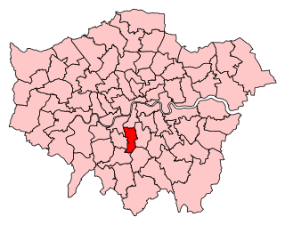
Wandsworth is a London borough in southwest London; it forms part of Inner London and has an estimated population of 329,677 inhabitants. Its main named areas are Battersea, Balham, Putney, Tooting and Wandsworth Town.

Lambeth is a London borough in South London, England, which forms part of Inner London. Its name was recorded in 1062 as Lambehitha and in 1255 as Lambeth. The geographical centre of London is at Frazier Street near Lambeth North tube station, though nearby Charing Cross on the other side of the Thames in the City of Westminster is traditionally considered the centre of London.

Lambeth is a district in South London, England, in the London Borough of Lambeth. Lambeth was an ancient parish in the county of Surrey. It is situated 1 mile south of Charing Cross. The population of the London Borough of Lambeth was 303,086 in 2011. The area experienced some slight growth in the medieval period as part of the manor of Lambeth Palace. By the Victorian era the area had seen significant development as London expanded, with dense industrial, commercial and residential buildings located adjacent to one another. The changes brought by World War II altered much of the fabric of Lambeth. Subsequent development in the late 20th and early 21st centuries has seen an increase in the number of high-rise buildings. The area is home to the International Maritime Organization. Lambeth is home to one of the largest Portuguese-speaking communities in the UK, and is the second most commonly spoken language in Lambeth after English.

The Metropolitan Borough of Wandsworth was a Metropolitan borough under the London County Council, from 1900 to 1965.

Lambeth was a civil parish and metropolitan borough in south London, England. It was an ancient parish in the county of Surrey. The parish was included in the area of responsibility of the Metropolitan Board of Works in 1855 and became part of the County of London in 1889. The parish of Lambeth became a metropolitan borough in 1900, following the London Government Act 1899, with the parish vestry replaced by a borough council.

The Diocese of Southwark is one of the 42 dioceses of the Church of England, part of the worldwide Anglican Communion. The diocese forms part of the Province of Canterbury in England. It was created on 1 May 1905 from part of the ancient Diocese of Rochester that was served by a suffragan bishop of Southwark (1891–1905). Before 1877 most of the area was part of the Diocese of Winchester, some being part of the Diocese of London.
Streatham is a constituency represented in the House of Commons of the UK Parliament since 2019 by Bell Ribeiro-Addy of the Labour Party.
Samuel Sanders Teulon was an English Gothic Revival architect, noted for his use of polychrome brickwork and the complex planning of his buildings.

The Tooting Commons consist of two adjacent areas of common land lying between Balham, Streatham and Tooting, in south west London: Tooting Bec Common and Tooting Graveney Common.

Brixton Hundred or the Hundred of Brixton was for many centuries a group of parishes (hundred) used for meetings and taxation of their respective great estates in the north east of the county of Surrey, England. Its area has been entirely absorbed by the growth of London; with its name currently referring to the Brixton district. Its area corresponds to London Boroughs: Southwark, Lambeth, Wandsworth and parts of Lewisham, Merton and Richmond upon Thames.

The Falconbrook was a stream that rose in Balham and Tooting, draining much of those parishes then the south and west of the larger district of Battersea including Clapham Junction to enter the London reaches of the Thames. Before doing so it briefly formed the border of Wandsworth Town, reflected in the SW11/SW18 boundary today.

All Saints' Church is a Church of England parish church in West Dulwich, South London. It is a red brick building designed in a Gothic Revival style by George Fellowes Prynne and built 1888–91. It is Grade I listed.
St Luke's Church in West Norwood is an Anglican church that worships in a Grade II* listed building. It stands on a prominent triangular site at the south end of Norwood Road, where the highway forks to become Knights Hill and Norwood High Street.

The Church of St Candida and Holy Cross is an Anglican church in Whitchurch Canonicorum, Dorset, England. A Saxon church stood on the site but nothing remains of that structure. The earliest parts of the church date from the 12th century when it was rebuilt by Benedictine monks. Further major rebuilding work took place in the 13th century and in the 14th century the church's prominent tower was constructed. The church features some Norman architectural features but is predominantly Early English and Perpendicular. George Somers, founder of the colony of Bermuda, is buried under the vestry and the assassinated Bulgarian dissident Georgi Markov is interred in the churchyard. It is an active Church of England parish church in the deanery of Lyme Bay, the archdeaconry of Sherborne, and the diocese of Salisbury. It is one of only two parish churches in the country to have a shrine that contains the relics of their patron saint. The relics belong to St Candida to whom the church is dedicated. The church been designated by English Heritage as a Grade I listed building.

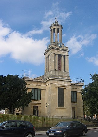
St Peter's Church is an Anglican church in the London Borough of Lambeth. It is a Grade II* listed building and occupies a prominent position in Leigham Court Road, Streatham.
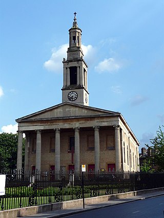
St Matthew's Church is a Church of England church in the London Borough of Lambeth. It is a Grade II* listed building which occupies a prominent position at the junction of Brixton Road, Brixton Hill and Effra Road. The church was constructed following the Church Building Act 1818 and was consecrated in 1824.

Holy Trinity Church, Trinity Rise, in the Tulse Hill area of the London Borough of Lambeth, is a Grade II Listed Building
St Paul's Church is a Church of England parish church in Clapham, London. There has been a church on the site since the 12th century. The current building was completed in 1815 and is Grade II* listed. In the grounds, which hold the Green Flag Award, are some fine tombs including many early 19th century sarcophagi and a community garden, Eden. The incumbent is Revd Canon Jonathan Boardman.

