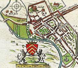
St Mary's Church, Cardiff

Last updated

St Mary's Church
Welsh: Eglwys Fair
John Speed's map of Cardiff 1610.jpg
John Speed's 1610 map of Cardiff, showing the southerly location of St Mary's Church, next to the River Taff.
St Mary's Church, Cardiff
Location Cardiff
Country Wales
Previous denomination Anglican
History
Status Church (former)
Founded1107
Architecture
Functional status
  • Abandoned (c.1701)
  • Demolished
Closedc.1701
Demolished1701 (Ruins)

St Mary's Church (Welsh : Eglwys Fair) was an Anglican church in Cardiff, Wales, which stood at the south end of the current St. Mary's Street, from 1107 until 1620. After severe flood damage it was abandoned in 1701 and later replaced at a different location in 1843.

Contents

Early history

St Mary's was founded as a Benedictine priory in the 1080s, by Robert Fitzhamon [1] (also founder of Tewkesbury Abbey in 1092). However, the site next to the River Taff was a poor one, susceptible to both continual flooding and river erosion. [2] Even after stabilising the foundations, bodies from burials would regularly be washed down the river. The abbey withdrew the monks in 1211. [3]

Destruction

In 1607, the area of England and Wales bordering the Bristol Channel experienced a devastating flood. The flood has been at various later times been attributed to a storm surge or a tsunami. [4] The Bristol Channel floods washed away much of St Mary's foundations [5] and it slowly began to collapse.

In 1620, the decision was made to make St John's the main parish church, which was originally just a chapel of ease. The two churches were worked as one parish, with all burials and some services continuing at St Mary's.

In 1638, the vicar of St Mary's, William Erbery, was forced to resign, his curate Walter Cradock had his licence revoked, and senior members of the congregation were barred from the premises after they refused to read the Book of Sports. These people, together with others of a similar mind, formed the core of a new congregation that, after the English Civil War and subsequent Restoration, in 1696 were granted land in Womanby Street which allowed them to build the first Trinity Church (later known as a Presbyterian chapel). [6]

By 1678, with evidence from the visit of Francis Place and later essays from the Celtic scholar Edward Lhuyd, both described St Mary's as being in ruins. The tower collapsed in 1680 [2] and the last recorded burial in the churchyard took place in 1698. [3] The last service was held in a roofless ruin in 1701, after which St Mary's was abandoned. [2]

Replacement and later developments

In 1843, John Crichton-Stuart, 2nd Marquess of Bute donated the land for the construction of the Church of St. Mary the Virgin (the present Church of St Mary and St Stephen) in Bute Street as a permanent replacement. [7] The cost of construction, however, was met by public appeal for funds. The 1843 church was designed by Thomas Foster of Bristol. The east end (by J. D. Sedding) was added in 1884, later enlarged in 1907. Wall paintings decorate the chancel arch. [8] The church is a Grade II listed building. [9] [10]

The River Taff was diverted in 1850 (by Isambard Kingdom Brunel) to create a site to build the Cardiff Central railway station, also resulting in the creation of Westgate Street.

The Theatre Royal (later the Prince of Wales theatre) was built on the site of the old church in 1878. [3] This is now the location of the current Prince of Wales public house. The outline of a Gothic church was included on one wall of the theatre, denoting its location on the St Mary's church site. [11]

See also

Related Research Articles

<span class="mw-page-title-main">Cardiff city centre</span> Central Business District in Wales

Cardiff city centre is the city centre and central business district of Cardiff, Wales. The area is tightly bound by the River Taff to the west, the Civic Centre to the north and railway lines and two railway stations – Central and Queen Street – to the south and east respectively. Cardiff became a city in 1905.

<span class="mw-page-title-main">Taff's Well</span> Human settlement in Wales

Taff's Well is a semi-rural village, community and electoral ward located at the south easterly tip of Rhondda Cynon Taf, 6 miles (9.7 km) to the north of Cardiff, the capital city of Wales. Known locally as the 'Gates to the Valleys', it is separated from Gwaelod-y-Garth by the River Taff. Taff's Well is distinguished because it contains the only thermal spring in Wales. The tepid water is thought to rise along a fault-line from the Carboniferous Limestone, in somewhat similar manner to the warm springs at Bristol and Bath. Various religious groups regard it as a spiritual site.

<span class="mw-page-title-main">Tongwynlais</span> Village and community in Cardiff, Wales

Tongwynlais is a village and community in the north of Cardiff, Wales, north of the M4 motorway in the Taff Valley. It is notable as the location of the hillside landmark, Castell Coch. The population as of the 2011 census was 1871.

<span class="mw-page-title-main">Merthyr Vale</span> Human settlement in Wales

Merthyr Vale is a linear village and community in the Welsh county borough of Merthyr Tydfil. Lying on the A4054 road it is on the east bank of the River Taff.

<span class="mw-page-title-main">Bute Street, Cardiff</span> Street in Cardiff, Wales

Bute Street is a street in Cardiff, Wales. It links Cardiff Bay and Butetown with Cardiff city centre. It now has no road number. It runs from the dockside of the Mermaid Quay complex in the south, which is now a pedestrian zone, to the junction of Bute Terrace (A4160) in the north.

<span class="mw-page-title-main">Cotham Church</span> Church in Bristol, England

Cotham Church is a Gothic Revival style church in Cotham, Bristol, England. Since 1975, it has been a Church of England parish church known as the Church of St Saviour with St Mary or simply as Cotham Parish Church.

<span class="mw-page-title-main">Cardiff Centenary Walk</span> Tourist walkway in Cardiff, Wales

The Cardiff Centenary Walk is a tourist walkway through Cardiff city centre in Wales. Established as part of Cardiff's centennial celebrations to mark 100 years of city status in 2005, it has 41 points of interest, either Cardiff landmarks or significant historic sites. The route is marked by waymarkers on the pavement, which also direct pedestrians to the next waymarker. The whole walk is 3.6 kilometres (2.2 mi) long running around Cardiff in a clockwise direction, starting and finishing at the Cardiff Visitor Centre at the Old Library.

<span class="mw-page-title-main">John Prichard</span> British architect (1817–1886)

John Prichard was a Welsh architect in the neo-Gothic style. As diocesan architect of Llandaff, he was involved in the building or restoration of many churches in south Wales.

<span class="mw-page-title-main">Culture and recreation in Cardiff</span> Overview of the culture and recreation possibilities in Cardiff

Cardiff has many cultural sites varying from the historical Cardiff Castle and out of town Castell Coch to the more modern Wales Millennium Centre and Cardiff Bay. Cardiff was a finalist in the European Capital of Culture 2008.

<span class="mw-page-title-main">St John the Baptist Church, Cardiff</span> Church in Cardiff, Wales

St John the Baptist Church is a Grade I listed parish church in Cardiff, Wales. Other than Cardiff Castle, it is the only medieval building in the city centre.

<span class="mw-page-title-main">Architecture of Cardiff</span> Overview of the architecture in the capital city of Wales

Architecture in Cardiff, the capital city of Wales, dates from Norman times to the present day. Its urban fabric is largely Victorian and later, reflecting Cardiff's rise to prosperity as a major coal port in the 19th century. No single building style is associated with Cardiff, but the city centre retains several 19th and early 20th century shopping arcades.

<span class="mw-page-title-main">Castle Quarter (Cardiff)</span> Area of Cardiff, Wales

Castle Quarter is an independent retail destination area in the north of the city centre of Cardiff, Wales. Castle is also a community (parish) of Cardiff.

The Vale of Glamorgan has 740 listed buildings of which 4% are Grade I listed, 10% Grade II* listed and remainder Grade II listed.

<span class="mw-page-title-main">Womanby Street</span> Street in Cardiff, Wales, United Kingdom

Womanby Street is one of the oldest streets in Cardiff, the capital of Wales. Tracing its name back to origins within the Norse language, its original purpose was to link Cardiff Castle to its quay. In this way it became a trade hub and settling point for those incomers who made the city their home. Throughout its history the street has had several pubs, and today has several bars and clubs.

<span class="mw-page-title-main">Listed buildings in Cardiff</span> Protected buildings in Cardiff, Wales

There are around 1,000 listed buildings in Cardiff, the capital city of Wales. A listed building is one considered to be of special architectural, historical or cultural significance, which is protected from being demolished, extended or altered, unless special permission is granted by the relevant planning authorities. The Welsh Government makes decisions on individual cases, taking advice from the heritage agency Cadw, the Royal Commission on the Ancient and Historical Monuments of Wales and local councils.

<span class="mw-page-title-main">Listed buildings in Cardiff Bay</span>

There are many listed buildings in Cardiff Bay, part of Cardiff, capital city of Wales. A listed building is one considered to be of special architectural, historical or cultural significance, and has restrictions on amendments or demolition. Buildings are listed as either Grade I, II* and II buildings lists, with the Grade I being the most important.

<span class="mw-page-title-main">Church of St Mary of the Assumption, Burnley</span> Church in Lancashire, England

The Church of St Mary of the Assumption is in Yorkshire Street, Burnley, Lancashire, England. It is an active Roman Catholic parish church in the diocese of Salford. The church is recorded in the National Heritage List for England as a designated Grade II listed building. It was built between 1846 and 1849 to replace a smaller chapel on a different site. The church was designed by Weightman and Hadfield in Decorated style, and a chapel was added to it in 1879.

<span class="mw-page-title-main">Mount Stuart Square</span> City square in Cardiff, Wales

Mount Stuart Square is a residential and commercial square in Cardiff, Wales. It is located in the Butetown area of the city. Originally developed in the late 1800s as a residential location for nearby dock workers, it quickly became a centre for upscale residential properties which revolved around the main square. By 1900, commercial activity had taken its place, dominated by the Coal Exchange, which occupied the once open central space. The square contains a high concentration of listed buildings, which represent a range of architectural styles and some of Cardiff's finest examples of late 19th and early 20th century commercial architecture. Mount Stuart Square area was designated a Conservation Area in July 1980.

References

  1. "Cardiff St. Mary". Cardiff. Genuki.org.uk. Retrieved 1 April 2013. Genuki quotes from The Old Parish Churches of Gwent, Glamorgan & Gower (1991), by Mike Salter.
  2. 1 2 3 "Cardiff city and Bay circular walk". BBC Wales . Retrieved 30 December 2012.
  3. 1 2 3 "Timeline". Cardiffians.co.uk. Retrieved 31 December 2011.
  4. "Anniversary of 1607 killer wave". BBC News. 30 January 2007. Retrieved 8 May 2013.
  5. Jenkins, William L. (1854). A History of the Town and Castle of Cardiff. Charles Wakeford. pp. 31–33. Retrieved 8 May 2013.
  6. "Trinity Chapel". ancestry.com. Retrieved 30 December 2012.
  7. "Bute". peterfinch.co.uk. Retrieved 30 December 2012.
  8. "St Mary the Virgin & St Stephen the Martyr Church, Bute Street (14227)". Coflein. RCAHMW . Retrieved 1 April 2013.
  9. "Parish Church of St Mary the Virgin and St Stephen the Martyr, including forecourt wall and railings, Butetown". British Listed Buildings. Retrieved 1 April 2013.
  10. Cadw. "Parish Church of St Mary the Virgin and St Stephen the Martyr, including forecourt wall and railings (Grade II) (13981)". National Historic Assets of Wales . Retrieved 3 April 2019.
  11. "The extraordinary stories of the theatre turned sex cinema which is now one of Wales' best known pubs". Wales Online. 27 August 2017. Retrieved 1 December 2018.

51°28′39″N3°10′40″W / 51.4775°N 3.1779°W / 51.4775; -3.1779