
Gloucester Cathedral, formally the Cathedral Church of St Peter and the Holy and Indivisible Trinity, in Gloucester, England, stands in the north of the city near the River Severn. It originated with the establishment of a minster, Gloucester Abbey, dedicated to Saint Peter and founded by Osric, King of the Hwicce, in around 679. The subsequent history of the church is complex; Osric's foundation came under the control of the Benedictine Order at the beginning of the 11th century and in around 1058, Ealdred, Bishop of Worcester, established a new abbey "a little further from the place where it had stood". The abbey appears not to have been an initial success, by 1072, the number of attendant monks had reduced to two. The present building was begun by Abbott Serlo in about 1089, following a major fire the previous year.
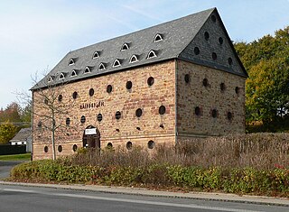
A tithe barn was a type of barn used in much of northern Europe in the Middle Ages for storing rents and tithes. Farmers were required to give one-tenth of their produce to the established church. Tithe barns were usually associated with the village church or rectory, and independent farmers took their tithes there. The village priests did not have to pay tithes—the purpose of the tithe being their support. Some operated their own farms anyway. The former church property has sometimes been converted to village greens.

Woodspring Priory is a former Augustinian priory. It is near the scenic limestone promontory of Sand Point and Middle Hope, owned by the National Trust, beside the Severn Estuary about 3 miles (5 km) north-east of Weston-super-Mare, within the English unitary authority of North Somerset. Many of the buildings are Grade I listed, and the whole site is scheduled as an ancient monument.
Swalcliffe is a village and civil parish about 5 miles (8 km) west of Banbury in Oxfordshire. The parish is about 2+1⁄2 miles (4 km) long north–south and about 1 mile (1.6 km) east–west. The 2011 Census recorded the population of the modern Swalcliffe parish as 210. The toponym "Swalcliffe" comes from the Old English swealwe and clif, meaning a slope or cliff frequented by swallows. The ancient parish of Swalcliffe was larger than the present civil parish, and included the townships of Epwell, Shutford, Sibford Ferris and Sibford Gower.
Launton is a village and civil parish on the eastern outskirts of Bicester, Oxfordshire, England. The 2011 Census recorded the parish's population as 1,204.

West Bradley is a village and civil parish 4 miles south-east of Glastonbury in the Mendip district of Somerset, England. The parish includes the hamlets of Hornblotton and Lottisham.

Woodnesborough is a village in the Dover District of Kent, England, 2 miles (3.2 km) west of Sandwich. The population taken at the 2011 census included Coombe as well as Marshborough, and totalled 1,066. There is a Grade II* listed Anglican church dedicated to St Mary the Virgin.

Longworth is a village and civil parish in the Vale of White Horse, England. The 1974 boundary changes transferred it from Berkshire to Oxfordshire. The village lies between Faringdon, 7 miles (11 km) to its west, and Oxford, 9 miles (14 km) to the north-east. The 2011 Census recorded a population of 566, which was estimated at 570 in 2019. The parish is bounded by the River Thames to the north, the A420 road to the south, and field boundaries to the east and west. The land slopes from the A420 to the river, except at Harrowdown Hill near the north-east corner of the parish, which has a summit of 325 feet (99 m).

Upwaltham is a scattered settlement and civil parish in the South Downs, in the District of Chichester of West Sussex, England. It surrounds a parish church, which is about 5 miles (8 km) south-southwest of Petworth on the A285 road.
Shefford Woodlands is a village in West Berkshire, England, about 3 miles (5 km) northeast of the market town of Hungerford. The village is in the civil parish of Great Shefford, about 1 mile (1.6 km) southeast of Great Shefford village. Shefford Woodlands is about 545 feet (166 m) above sea level in the Berkshire Downs, and just north of Junction 14 on the M4.

Edwardstone is a village and civil parish in the Babergh district, in the county of Suffolk, England. The parish contains the hamlets of Mill Green, Priory Green, Round Maple and Sherbourne Street, and Edwardstone Woods, a Site of Special Scientific Interest. The parish touches Boxford, Great Waldingfield, Groton, Little Waldingfield, Milden and Newton.
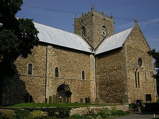
The Minster Church of St Mary, Stow in Lindsey, is a major Anglo-Saxon church in Lincolnshire and is one of the largest and oldest parish church buildings in England. It has been claimed that the Minster originally served as the cathedral church of the diocese of Lindsey, founded in the 7th century and is sometimes referred to as the "Mother Church of Lincolnshire".

The Grade I listed buildings in Somerset, England, demonstrate the history and diversity of its architecture. The ceremonial county of Somerset consists of a non-metropolitan county, administered by Somerset County Council, which is divided into five districts, and two unitary authorities. The districts of Somerset are West Somerset, South Somerset, Taunton Deane, Mendip and Sedgemoor. The two administratively independent unitary authorities, which were established on 1 April 1996 following the breakup of the county of Avon, are North Somerset and Bath and North East Somerset. These unitary authorities include areas that were once part of Somerset before the creation of Avon in 1974.
Mendip is a local government district in the English county of Somerset. The Mendip district covers a largely rural area of 285 square miles (738 km2) ranging from the Mendip Hills through on to the Somerset Levels. It has a population of approximately 11,000. The administrative centre of the district is Shepton Mallet.

Westwell is a small village and civil parish about 2 miles (3 km) southwest of the market town of Burford in Oxfordshire. It is the westernmost village in the county, close to the border with Gloucestershire.

Wilmington Priory was a Benedictine priory in the civil parish of Long Man, East Sussex, England. The surviving building is now owned by the Landmark Trust and let as holiday accommodation. It is both a Grade I listed building and a scheduled monument.

There are 42 Grade I listed buildings in Maidstone. The Borough of Maidstone is a local government district in the English county of Kent. The district covers a largely rural area of 152 square miles (394 km2) between the North Downs and the Weald with the town of Maidstone, the county town of Kent, in the north-west. The district has a population of approximately 166,400 in 2016.
Cheshire is a county in North West England. In 1974 parts of the historical county of Cheshire were transferred to Greater Manchester and to Merseyside, and parts of the historical county of Lancashire were incorporated into Cheshire, including the towns of Widnes and Warrington. The unitary authorities of Halton and Warrington were created in 1998, and in 2009 the rest of the county was divided into two further unitary authorities: Cheshire East, and Cheshire West and Chester. The ceremonial county of Cheshire consists of those four unitary authorities.

There are 19 Grade I listed buildings in the City of Coventry. In the United Kingdom, a listed building is a building or structure of special historical or architectural importance. These buildings are legally protected from demolition, as well as from any extensions or alterations that would adversely affect the building's character or destroy historic features. Listed buildings in England and Wales are divided into three categories—Grade II buildings are buildings of special interest; Grade II* buildings are Grade II buildings of particular interest; and Grade I buildings, which are those of "exceptional" interest. Only around four per cent of listed buildings are given Grade I status.
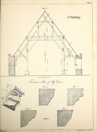
The Sextry Barn was a 13th-century tithe barn in Ely, Cambridgeshire, England. It was one of the largest medieval barns in Europe, and was demolished in 1842. It was used to store the corn tithes due to Ely Cathedral, and took its name from the sacrist of the monastery who was in charge of it.

