Pentraeth is a village and community on the island of Anglesey, North Wales, at grid reference SH523786. The Royal Mail postcode begins LL75. The community population taken at the 2011 census was 1,178. The village itself having a population of 557.

Din Lligwy hut circle is an ancient village site near the east coast of Anglesey, close to the village of Moelfre, North Wales.

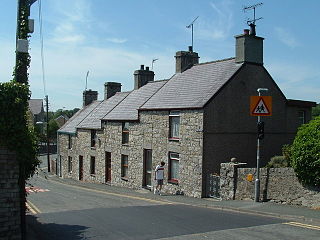
Moelfre is a village, a community and until 2012 an electoral ward on the north-east coast of the Isle of Anglesey in Wales. The community area covers the village and harbour, and several smaller, dispersed settlements. It includes six scheduled Iron Age hut groups and many other sites of archaeological interest. The harbour was formerly a local fishing port; a lifeboat station has been based here since 1854. Among many shipwrecks off the coast was that of the Royal Charter in 1859. Near the modernised lifeboat station is the RNLI Seawatch Centre. The coastline includes a rocky headland north of the village and a large sandy beach at Lligwy Bay, both traversed by the Anglesey Coastal Path. The 2011 census measured the village population as 710. It was estimated at 614 in 2019.

Lligwy Bay is a bay of the Welsh island of Anglesey.
Dulas Bay is a small bay on the north east coast of Anglesey, north Wales, forming the boundary between Llaneilian and Moelfre communities. The bay is bordered by three beaches.

Ynys Moelfre is a small island off the coast of Anglesey, Wales. At low tide it has a maximum length of 261 metres and a maximum width of 121 metres with a maximum area of 6.6 acres (27,000 m2). The nearest settlement to the island is the village of Moelfre, and the two are separated by a shallow channel called Y Swnt, which is never more than 194 metres wide and can at low tide only be waist-deep all the way across. At extreme low Spring tides, it is possible to walk across to the island on dry ground all the way. Due to its proximity to the mainland there are grasses found on the island and a few wild flowers. Species of birds that can be found on the island include gulls, terns, gannets, fulmars, and Great/Arctic skuas. A colony of seals live there and porpoises are occasionally seen also. There are, however, no man-made structures. It is referred to by some locals as Rat Island.
Brynrefail is a small village in north-east Anglesey, Wales.

Lligwy Burial Chamber is a Neolithic burial chamber in Lligwy, near the east coast of Anglesey, Wales, United Kingdom. It consists of a circle of upright stones, made into a low chamber by a very large roof slab estimated at 25 tonnes. Excavation in 1909 found the remains of some 15 to 30 people, and pottery suggesting a late Neolithic date. Close to the village of Moelfre, the site is within a few metres of the road, where there is room to leave a single car for short periods.

St Mary's Church, Bodewryd is a small medieval church in the hamlet of Bodewryd, in Anglesey, north Wales. The date of construction is unknown, but there was a church on this site in 1254 and the earliest feature to which a date can be given is a doorway in a 15th-century style dating to around 1500. When the church was restored in 1867 after being struck by lightning, stained glass with Islamic-influenced patterns was included in the windows, a requirement of Lord Stanley of Alderley, the church's benefactor, who was a convert to Islam.

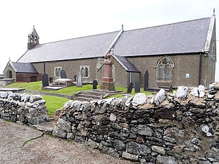
Capel Lligwy is a ruined chapel near Rhos Lligwy in Anglesey, north Wales, dating back to the first half of the 12th century. The chapel's original purpose is unknown, but it might have been used as a memorial chapel or in connection with a local royal court, or as a chapel of ease in a large parish with a growing population. It was used for a time until the early 18th century as a private place of worship for a nearby house, then later fell into disrepair. The walls still remain, with some traces of render on them internally, but there is no roof.

Llanfechell is a village in Anglesey, Wales. It is the largest of several small villages and dispersed settlements that make up Mechell Community Council area. It is 11 miles (18 km) east of Holyhead, and 5.6 miles (9 km) west of Amlwch, in the north of the island.

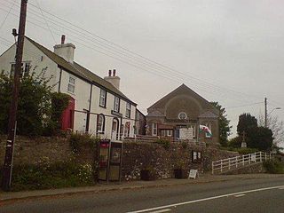
The Panton Arms Hotel, in Pentraeth, Anglesey, is a Grade II listed building situated in the centre of the village. It is named after the Panton family, former landowners from the nearby Plas Gwyn estate. It was built in early-mid 18th century and was listed in 1969. Charles Dickens stayed in the hotel in 1859 when he was sent to cover the sinking of the Royal Charter near Moelfre for his newspaper.

St Maethlu's Church is a medieval church in the village of Llanfaethlu, Anglesey, Wales. It is one of a number of churches in the parish and benefice of Bro Padrig, the appointed clergyman being the Reverend T. J. Jones. The building dates from the 15th century and underwent renovations in the early twentieth century. It was designated a Grade II*-listed building on 4 May 1971.

St Dyfnan's Church is a medieval church in the village of Llanddyfnan, Anglesey, Wales. The building dates from the 14th century and underwent extensive renovations in the mid-19th century. The church lies north from the B5109 road. It was designated as a Grade II*-listed building on 5 December 2007.

St Michael's Church is a medieval church in the village of Llanfihangel Din Sylwy, Anglesey, Wales. The building dates from the 15th century and was rebuilt in 1855. It was designated a Grade II*-listed building on 30 January 1968.
St Peter's Church is a medieval church in the village of Newborough, Anglesey, Wales. The building dates from the early 14th century and underwent restorations in the 19th century. It was designated a Grade II*-listed building on 30 January 1968. It has an interesting history and is the longest church on Anglesey.

St Llwydian's Church is a Grade II listed church in Heneglwys, Anglesey, Wales. The building dates to 1845, though it was erected using material from an earlier church. The circular font is as old as the 12th century, and the Church in Wales notes that an "unusually high number of 12th century stones" used in the church's construction indicate that the original church stemmed from that period. The doorway in the north wall is of 14th-century origin; the two windows with cinquefoil lights, of the 15th century.

St Trygarn's Church is a Church in Wales parish church in the Diocese of Bangor which covers its location at Llandrygarn, Anglesey, Wales. It was built in the 13th century and is a Grade II listed building. The church is the sole monument in Llandrygarn.

The Penrhos Feilw Standing Stones are a pair of standing stones on Holy Island west of Anglesey in north-west Wales. They are thought to date from the Bronze Age but their origins and purpose are unclear. They are about 3 m (10 ft) high and are a similar distance apart.

