St Michael's Church, Rudbaxton

Last updated
St Michael's Church
St Michael's Rudbaxton - geograph.org.uk - 408784.jpg
St Michael's Church, Rudbaxton
Pembrokeshire UK location map.svg
Red pog.svg
St Michael's Church
Location in Pembrokeshire
51°50′46″N4°57′40″W / 51.846°N 4.961°W / 51.846; -4.961
CountryWales
Denomination Church in Wales
History
Dedication St Michael
Architecture
Heritage designationGrade I
Architectural type Church

St Michael's Church is a Grade I listed building and parish church in the community and parish of Rudbaxton in Pembrokeshire, Wales. The building dates from the 15th century, and has a 12th-century font. It was listed on 1 March 1963 as a fine example of a substantial mediaeval double-nave church with important memorials.

Contents

Parish history

The ancient parish of Rudbaxton was in the hundred of Dungleddy, a corruption of the Welsh for two Cleddau, referring to the Eastern and Western Cleddau rivers, which form part of the parish boundary. It appeared as Redbaxton on a 1578 parish map of Pembrokeshire. [1] The Haverfordwest to Fishguard turnpike (now the A40) ran through the western half of the parish. Once entirely rural and agricultural, the parish now includes the northeastern part of the expanding county town of Haverfordwest. There were two chapels of ease in the parish, dedicated to St Margaret and St Catherine, but both were in ruins before the 1830s. [2] [3] The former parish of Rudbaxton is now in the combined parish of Daugleddau in the Diocese of St Davids. [4]

Opposite the church is Rudbaxton Rath, the remains of a prehistoric fortification whose origins are obscure. [2] [5]

Church

The earliest record of a church on the site was made by Wizo, one-time lord of Wiston, in a grant to the Knights Hospitallers of St John of Jerusalem in the 12th century, referring to it as Ecclesia Rudepagstona. Before it was dedicated to St Michael, a church on the site was dedicated to St Madoc. A royal commission in 1920 listed the church as having 13th century origins with a later added aisle and a two-storey tower with 24 stairs, and noted that a spring outside the churchyard was named St Madoc's Well. [6]

Structure

The parish church of St Michael was originally established prior to the fifteenth century (there is a 12th-century font), but the present building, built of rubble stone with slate roofing, retains some late-15th or early-16th century features. The building was restored "from a state of ruin" by the rector in the 19th century. [2] The tower has a vaulted base. The nave is probably earlier than the chancel, the arch of which, along with the roofs, was replaced in 1845 by Ewan Christian. [7] [8]

In 1892, the church was further restored by R. G. Pinder of Bournemouth, who replaced all the roofs and many of the fittings, bringing the building to its present state whilst retaining many parts of the earlier structures. The internal walls are plastered and painted. The tower was lime-rendered in 2000. [7]

Fittings

The oak pulpit is 20th century. The font, rectangular and scalloped with a round base, is 12th century. The 1892 renovation added simple pine pews to the nave and chancel; the pews in the aisle are earlier, grained wood. Several windows have stained or coloured glass fitted in the 19th, 20th and 21st centuries. [7]

Memorials

Howard

Howard Memorial Howard monument Rudbaxton - geograph.org.uk - 408811.jpg
Howard Memorial

There is a significant monument to the local Howard family, probably commissioned by Joanna, wife of the Reverend James Howard in 1685 and depicting several family members and described as one of the finest memorials in the county. [7] Pevsner describes it as "splendidly large" and notes that the carved figures have no parallels in Pembrokeshire, suggesting that they may have been imported from Bristol. The authors criticise the modern repainting, undertaken "without research as to the original scheme". [9]

Picton

Lieutenant-General Sir Thomas Picton, the most senior officer to die at the Battle of Waterloo, has a memorial slab in the chancel floor and a Romanesque bust in the wall. [7] Picton was born in Haverfordwest in 1758, and grew up at Poyston Hall in the parish. [10] [11] Other Pictons are memorialised in the church, [7] including Thomas's brother John, also a general in the army, who is buried in the church, [12] and another General Picton, William, who died in 1811 and was buried in the family vault in St George's, Hanover Square. [13] John Picton's memorial is framed by a lion, a shield and banners, although Pevsner notes that the sculptor, Daniel Mainwaring of Carmarthen, had "clearly never seen a lion". [9]

Others

There are numerous other 18th, 19th and 20th century monuments and memorials dating from 1665 to 1909 to local people from servant to architect to archbishop, this last being a brass plate to William Laud, who was rector from 1622 to 1626, [7] during his time as Bishop of St Davids. [14] There is a plaque remembering six parishioners who lost their lives during World War I. [15]

Related Research Articles

<span class="mw-page-title-main">Haverfordwest</span> Human settlement in Wales

Haverfordwest is the county town of Pembrokeshire, Wales, and the most populous urban area in Pembrokeshire with a population of 14,596 in 2011. It is also a community, being the second most populous community in the county, with 12,042 people, after Milford Haven. The suburbs include the former parish of Prendergast, Albert Town and the residential and industrial areas of Withybush.

<span class="mw-page-title-main">Cilgerran</span> Human settlement in Wales

Cilgerran is both a village, a parish, and also a community, situated on the south bank of the River Teifi in Pembrokeshire, Wales. It was formerly an incorporated market town.

<span class="mw-page-title-main">St Mary's Church, Tenby</span> Church in Tenby, Wales

St Mary's Church, Tenby is a church located in the centre of the town of Tenby in Pembrokeshire, western Wales. The church is in the Diocese of Saint David's within the Church in Wales, and a member of the Anglican Communion. It is the parish church for St Mary In Liberty and St Mary Out Liberty.

<span class="mw-page-title-main">Walton East</span> Human settlement in Wales

Walton East is a small rural village and parish established around a church at least as early as Norman times. It is 2 miles (3.2 km) southwest of Llys y Fran and 1+12 miles (2.4 km) north of Clarbeston Road and in Wiston community in Pembrokeshire, Wales.

Canaston Bridge is the location in Pembrokeshire, southwest Wales where the A40 trunk road crosses the Eastern Cleddau. It is on the edge of the Pembrokeshire Coast National Park, 14 miles (23 km) northeast of Pembroke, and close to Oakwood Theme Park and Blue Lagoon waterpark. It is about half a mile upstream of Blackpool Mill, at the normal tidal limit of the river.

Boulston is a small settlement and former parish on the left bank of the Western Cleddau river in Pembrokeshire, Wales, in the community of Uzmaston, Boulston and Slebech.

<span class="mw-page-title-main">Treffgarne</span> Human settlement in Wales

Treffgarne is a small village and parish in Pembrokeshire, south-west Wales. It lies to the south of the Preseli Hills close to the Western Cleddau river, and close to the main A40 road from Fishguard to Haverfordwest. The area has an interesting local geology and evidence of mineral extraction at least as far back as Roman times. The present village is medieval in origin.

<span class="mw-page-title-main">Warren, Pembrokeshire</span> Parish in Pembrokeshire, Wales

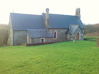
Warren is an ancient parish in the community of Stackpole and Castlemartin, in the most southerly part of Pembrokeshire, Wales. Its northern edge is 5 miles (8 km) south of Pembroke and its southern edge reaches the sea at Flimston Bay. It is bordered by Castlemartin to the west, St Twynnells to the east and Monkton to the north.

<span class="mw-page-title-main">Uzmaston</span> Human settlement in Wales

Uzmaston is a small parish in Pembrokeshire, Wales, about 2 kilometres south-east of Haverfordwest. The village, to the northwest of Boulston, forms part of the community of Uzmaston, Boulston and Slebech, and lies near the bank of the Western Cleddau. It contains the Grade II listed St. Ismael's Parish Church which has existed since at least 1230, and was extensively rebuilt in 1870-73 and restored in the 1990s.

Llandeilo Llwydarth or Llandilo is an ancient area and parish in the Preseli Hills between Llangolman and Maenclochog in the community of Maenclochog, Pembrokeshire, Wales.

<span class="mw-page-title-main">Rudbaxton</span> Human settlement in Wales

Rudbaxton is a village, parish and a local government community in the county of Pembrokeshire, Wales. It is 81 miles (130 km) from Cardiff and 208 miles (335 km) from London.

<span class="mw-page-title-main">Scleddau</span> Human settlement in Wales

Scleddau is a village and a community in the county of Pembrokeshire, Wales, and is 2 miles (3.2 km) south of Fishguard on the main A40 road. The Western Cleddau river which lends its name to the village flows under the main road. There are several springs in the village.

<span class="mw-page-title-main">Haroldston St. Issell's</span> Human settlement in Wales

Haroldston St Issells is a former parish in Pembrokeshire, Wales, on the upper reaches of the Western Cleddau, 1 mile (1.6 km) southeast of Haverfordwest. Its area is 1,104 acres (447 ha); Haroldston church is co-located with Lower Haroldston and is a small attractive building. Haroldston ruins and Lower Haroldston can both be viewed from a circular walk along the banks of the Cleddau. Haroldston and other places in the parish are preserved as historic place names by the Royal Commission.

<span class="mw-page-title-main">Prendergast, Pembrokeshire</span> Village in Pembrokeshire, Wales

Prendergast is a former village and parish in Pembrokeshire, Wales, now a suburb of Haverfordwest, Pembrokeshire's county town. The name survives as an electoral ward of Haverfordwest. The Western Cleddau forms the parish's western boundary, and the Hiog, a tributary of the Cleddau, the eastern boundary.

<span class="mw-page-title-main">Haroldston West</span> Parish in Pembrokeshire, Wales

Haroldston West is a rural coastal parish in west Pembrokeshire, Wales, 5.5 miles (8.9 km) west of Haverfordwest. It is in the community of Merlin's Bridge.

<span class="mw-page-title-main">Gelli, Pembrokeshire</span> Village in Pembrokeshire, Wales

Gelli is a small settlement in the community and parish of Llawhaden, Pembrokeshire, Wales, at the confluence of the Syfynwy and Cleddau Ddu rivers. It is 3 miles (5 km) northwest of Narberth and 8 miles (13 km) east of Haverfordwest. The nearest railway station is at Clunderwen 2 miles (3 km) to the east. There was a woollen mill in Gelli that ceased production in 1938.

<span class="mw-page-title-main">Llanstinan</span> Rural parish in Wales

Llanstinan is a rural parish in the community of Scleddau, north Pembrokeshire, Wales, 3 miles (4.8 km) south of Fishguard.

<span class="mw-page-title-main">St David's Church, Hubberston</span> Church in Pembrokeshire, Wales

St David's Church, Hubberston is the parish church of Hubberston, a village on the north bank of the Milford Haven Waterway, in south Pembrokeshire, Wales. The church has 15th century origins, was subsequently renovated and restored, and is a Grade I listed building.

<span class="mw-page-title-main">St Nicholas & St John, Monkton</span> Church in Pembrokeshire, Wales

The Church of St Nicholas & St John, formerly the Priory Church of St Nicholas, is the parish church of Monkton, a village on the south bank of the Milford Haven Waterway, in south Pembrokeshire, Wales. The church's medieval origins link it to Monkton Priory, founded in the 11th century. It is a Grade I listed building.

<span class="mw-page-title-main">St Elidyr's Church, Stackpole</span> Church in Pembrokeshire, Wales

St Elidyr's Church, is a Grade I listed building in south Pembrokeshire, Wales. The church is in the small village of Carew Cheriton in the southwest of the parish of Stackpole Elidor, on the Stackpole Estate in the community of Stackpole and Castlemartin.

References

  1. "Penbrok comitat". British Library.
  2. 1 2 3 "GENUKI: Rudbaxton" . Retrieved 16 May 2020.
  3. "GENUKI:Rudbaxton parish map 76" . Retrieved 28 July 2019.
  4. "Diocese of St Davids: St Michael, Rudbaxton" . Retrieved 16 May 2020.
  5. "Crundale Rath, Rudbaxton (305250)". Coflein. RCAHMW . Retrieved 29 September 2021.
  6. An Inventory of the Ancient Monuments in Wales and Monmouthshire. 1925. pp. 315–317. Retrieved 16 May 2020.
  7. 1 2 3 4 5 6 7 Cadw. "Church of St Michael (Grade I) (12009)". National Historic Assets of Wales . Retrieved 16 May 2020.
  8. "British listed buildings: Church of St Michael" . Retrieved 16 May 2020.
  9. 1 2 Lloyd, Thomas; Orbach, Julian; Scourfield, Robert (2004). Pembrokeshire. The Buildings of Wales. New Haven, US and London: Yale University Press. pp. 380–381. ISBN   0300101783. OCLC   978065767.
  10. Havard, Robert (2004). "Picton, Sir Thomas (1758–1815)". Oxford Dictionary of National Biography (online ed.). Oxford University Press. doi:10.1093/ref:odnb/22219.(Subscription or UK public library membership required.)
  11. Johnston, S. H. F. (1959). PICTON, Sir THOMAS (1758 - 1815), a soldier. Dictionary of Welsh Biography. Retrieved 1 May 2019.
  12. Mark Muller (13 February 2014). "Muller's Corner: Rudbaxton Church". Wales online. Retrieved 16 May 2020.
  13. "Maritime Memorials: M5489" . Retrieved 16 May 2020.
  14. Milton, Anthony. "Laud, William (1573–1645)". Oxford Dictionary of National Biography (online ed.). Oxford University Press. doi:10.1093/ref:odnb/16112.(Subscription or UK public library membership required.)
  15. "War Memorials Online: St Michael's, Rudbaxton" . Retrieved 16 May 2020.