St Olave's Church, Southwark

Last updated

St Olave's, Southwark, engraving by Benjamin Cole, 1756 St Olaves Southwark by Benjamin Cole.png
St Olave's, Southwark, engraving by Benjamin Cole, 1756

St Olave's Church, Southwark was a church in Southwark, England which is believed to be mentioned in the Domesday Book of 1086. It was located on Tooley Street which is named after the church, i.e. 't'olous'. It became redundant in 1926 and was demolished. It is now the location of St Olaf House, which houses part of the London Bridge Hospital.

Contents

Dedication

Depiction on St Olaf II on the side of St Olaf House St Olave on the exterior of St Olaf's House.jpg
Depiction on St Olaf II on the side of St Olaf House

The church was dedicated to Olav Haraldsson, an early King of Norway, who attempted to convert his people to Christianity and was martyred in 1030. Before this, in 1014, he was a prince and an ‘ally’ (i.e. mercenary) of King Æthelred the Unready, fighting the Danes. While they were occupying the wooden London Bridge, Olav is said to have tied his long-boats to the bridge supports and pulled it down. [1] The church’s probable beginning is as a private chapel of Godwin, Earl of Wessex from at least 1018, and his Southwark interest was probably contemporary to this. He would probably have known Olav personally, so the dedication was quite apposite.

Whatever the veracity of the story of London Bridge, Olav became a popular saint in England, and five churches in the City of London were dedicated to him, apart from the church at Southwark.

Domesday Book

St Olave’s is presumed to be the church mentioned in the Southwark Domesday Book entry, from which it appears that it had royal patronage before the Norman Conquest of England in 1066.

The Domesday entry for Southwark has the following three statements relating to the interests of Odo, Bishop of Bayeux and Earl of Kent: [2]

Bishop Odo, William the Conqueror’s half-brother who seems to have succeeded to the Godwin interest, had attempted to let out the church but he should have sought the king’s authority to do so. The earliest priests of the church were named Adelold (Athelwold) and then Ralph before 1086. The church is first mentioned by name in 1096 in relation to its priest ‘Peter de St Olavo’ being party to a land transaction involving Bermondsey Priory. [4]

Early Medieval Period

This sword rest, now in Southwark Cathedral, formerly stood in the church. It bears the Bridge Mark (blue logo on right-hand side) of the Bridge House which was nearby. Sword rest TQ3280 427.jpg
This sword rest, now in Southwark Cathedral, formerly stood in the church. It bears the Bridge Mark (blue logo on right-hand side) of the Bridge House which was nearby.
St Olaf House, Southwark St Olaf House 012.jpg
St Olaf House, Southwark

Sometime between 1090 and 1121 the Warennes (successors to Odo) had given the church and neighbouring property to Lewes Priory. Although situated next to the old London Bridge, its parish took in the north-east end of the High Street and stretched out along to the east and to the south where it was limited by Bermondsey parish. [5]

The Norman stone church, which replaced a Saxon structure which may have been built of timber, was so close to the river that when a terrible flood affected the banks of the Thames in 1327 it was reported that the water had damaged the church walls and washed away bodies from the churchyard. [6]

Stuart and Georgian era

Part of the Norman building collapsed through a combination of age, neglect, and river subsidence, in 1736. In 1737 this was replaced by a new church designed by Henry Flitcroft and built by Master Mason John Deval, [7] which in turn was severely damaged in a major fire in Tooley Street in 1843. [8] Sculptural work was by Christopher Horsnaile and John Deval. [9]

Henry Gauntlett was the church's organist from 1827 to 1846 and during those years designed a grand new organ which replaced an older one.

The civil parishes of Southwark St Olave, Southwark St John Horsleydown, and Southwark St Thomas, were administered by the St Olave District Board of Works from 1855. The parish also gave its name to the St Olave's Poor Law Union which included the parishes of Bermondsey and Rotherhithe, and in 1900 this combination became the Metropolitan Borough of Bermondsey.

Notable people connected with the church

Depopulation of the parish, redundancy and demolition of the church

The church was restored and was very much a Docklands church, but as the industrial expansion of the area led to population decline, so the church became less used. In 1926 it was declared redundant and the nave was demolished, leaving a forlorn tower, removed in 1928, when its capping turret was relocated to Tanner Street Park, Southwark, where it was converted into a drinking fountain. This still stands in the Park and in 1998 was designated by English Heritage as a Grade II listed structure. [12]

The site of the church was sold and redeveloped with an Art Deco office building which became the headquarters of the Hay’s Wharf Company. This still stands on Lower Tooley Street and is now called St Olaf House; it bears a plaque giving information on the demolished St Olave's Church and its patron saint.

Legacy

The parish church was the originator of St Olave's Grammar School for boys, in 1896 renamed the St Olave's and St Saviour's Grammar School, and from 1902 its foundation also funded the St Saviour's and St Olave's Church of England School for girls. A separate St Olave's Foundation Fund still supports local youth's educational and vocational aspirations through grants.

The St Olave's United Charities parochial foundation, based in nearby Druid Street, is one of the best endowed of the Southwark parish charities, providing for local poor and elderly. The endowment was supplemented until the mid-1990s by a 'parish rate' over the area. [13]

Related Research Articles

<span class="mw-page-title-main">Southwark</span> District of Central London, England

Southwark is a district of Central London situated on the south bank of the River Thames, forming the north-western part of the wider modern London Borough of Southwark. The district, which is the oldest part of South London, developed due to its position at the southern end of the early versions of London Bridge, the only crossing point for many miles.

<span class="mw-page-title-main">Bermondsey</span> District in the London Borough of Southwark

Bermondsey is a district in southeast London, part of the London Borough of Southwark, England, 2.5 miles (4.0 km) southeast of Charing Cross. To the west of Bermondsey lies Southwark, to the east Rotherhithe and Deptford, to the south Walworth and Peckham, and to the north is Wapping across the River Thames. It lies within the historic county boundaries of Surrey.

<span class="mw-page-title-main">Rotherhithe</span> Residential district in southeast London, England

Rotherhithe is a district of south-east London, England, and part of the London Borough of Southwark. It is on a peninsula on the south bank of the Thames, facing Wapping, Shadwell and Limehouse on the north bank, as well as the Isle of Dogs to the east of the Thames and is a part of the Docklands area. It borders Bermondsey to the west and Deptford to the south east.

<span class="mw-page-title-main">Metropolitan Borough of Southwark</span>

The Metropolitan Borough of Southwark was a metropolitan borough in the County of London from 1900 to 1965. It was created to cover the western section of the ancient borough of Southwark and the parish of Newington. In common with the rest of inner London, the borough experienced a steady decline in population throughout its existence. The borough council made an unsuccessful attempt to gain city status in 1955. Its former area is now the northwestern part of the current London Borough of Southwark.

<span class="mw-page-title-main">St Olave's Grammar School</span> Voluntary aided grammar school in Orpington, Greater London, England

St. Olave's Grammar School is a selective secondary school for boys in Orpington, Greater London, England. Founded by royal charter in 1571, the school occupied several sites in Southwark, before establishing a location on Tooley Street in 1893. It moved to the suburb of Orpington in 1968, and has admitted girls to its sixth form since 1998.

<span class="mw-page-title-main">Tooley Street</span>

Tooley Street is a road in central and south London connecting London Bridge to St Saviour's Dock; it runs past Tower Bridge on the Southwark/Bermondsey side of the River Thames, and forms part of the A200 road.

<span class="mw-page-title-main">Bermondsey Abbey</span> English Benedictine monastery

Bermondsey Abbey was an English Benedictine monastery. Most widely known as being founded in the 11th century, it had a precursor mentioned in the early eighth century, and was centred on what is now Bermondsey Square, the site of Bermondsey Market, Bermondsey, in the London Borough of Southwark, southeast London, England.

St Saviour's Grammar School was a free grammar school for boys located in the borough of Southwark, south of the River Thames in London, England. It existed as a separate entity from 1559 until 1896, when it was amalgamated with St Olave's Grammar School, which was renamed St Olave's and St Saviour's Grammar School For Boys.

The Borough Compter was a small compter or prison initially located in Southwark High Street but moved to nearby Tooley Street in 1717, where it stood until demolished until 1855. It took its name from 'The Borough', a historic name for the Southwark area of London on the south side of the River Thames from the City of London. This replaced a lock-up as part of the City's court house under the jurisdiction of the Lord Mayor and Court of Aldermen of the City, and their High-Bailiff of Southwark. This first court house was converted from the old church of the parish St Margaret. A floor was made across the level of the church's gallery and the windows below that were blocked in, the Court Room being on the first floor. This structure was destroyed in the Great Fire of Southwark in 1676.

Bermondsey was a parish in the metropolitan area of London, England.

<span class="mw-page-title-main">A200 road</span>

The A200 is an A road in London running from London Bridge to Greenwich. It runs east from the A3 road along Duke Street Hill, then Tooley Street and Jamaica Road, following the River Thames until the junction with Rotherhithe Tunnel when it turns south down Lower Road. It follows the Thames again in Deptford, after passing Surrey Quays and becoming Evelyn Street. At the junction with Deptford Church Street it turns due east along Creek Road, over Deptford Creek to finish by the Cutty Sark at Greenwich Church Street, part of the A206 road.

<span class="mw-page-title-main">St John Horsleydown</span>

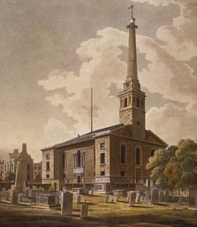
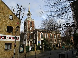
St John Horsleydown was the Anglican parish church of Horsleydown in Bermondsey, South London. Built for the Commission for Building Fifty New Churches to the designs of Nicholas Hawksmoor and John James in 1726–1733, it was noted for its distinctive spire in the form of a tapering column.

<span class="mw-page-title-main">St Mary Magdalen Bermondsey</span> Church in Bermondsey in the London Borough of Southwark, England

St Mary Magdalen Bermondsey is an Anglican church dedicated to St Mary Magdalen in Bermondsey in the London Borough of Southwark. The majority of the present building is late 17th century and is Grade II* listed.

<span class="mw-page-title-main">St Saviour's and St Olave's Church of England School</span> Voluntary aided school in London, England

St Saviour's and St Olave's Church of England School is a secondary school and sixth form for girls located on New Kent Road near Elephant and Castle, in the London Borough of Southwark, England. It is a voluntary aided Church of England school in the Anglican Diocese of Southwark and is affiliated to the Woodard Schools group.

The King's Manor - formally 'The City of London's King's Manor of the Town and Borough of Southwark' - is an institution of the City of London which is not a Livery Company as it is territorially rather than trade based, being the organisation of the Juror freemen of the Court Leet. The Manor covers the area from the western-side of Borough High Street, Southwark, to the borders of Newington and Lambeth. The manor originally lay in Surrey.

<span class="mw-page-title-main">Bermondsey Square</span> Public square in Bermondsey, London

Bermondsey Square is on Tower Bridge Road in Bermondsey, south London, England. It was the site of the 11th-century Bermondsey Abbey. The earliest medieval remains found are a Norman church from around 1080, which was recorded in the Domesday Book of 1086. The area has subsequently undergone redevelopment and Bermondsey Square now contains apartments, offices, a boutique hotel, restaurants, an independent cinema and Bermondsey Market.

<span class="mw-page-title-main">St Olave District (Metropolis)</span>

St Olave was a local government district within the metropolitan area of London, England from 1855 to 1900. It was formed by the Metropolis Management Act 1855 and was governed by the St Olave District Board of Works, which consisted of elected vestrymen.

<span class="mw-page-title-main">Southwark St Olave</span>

Southwark St Olave was an ancient civil and ecclesiastical parish on the south bank of the River Thames, covering the area around where Shard London Bridge now stands in the modern London Borough of Southwark. The boundaries varied over time but in general the parish stretched east from London Bridge past Tower Bridge to St Saviour's Dock. Southwark St Olave and St Thomas replaced the civil parish in 1896. It was abolished in 1904 and absorbed by Bermondsey parish.

<span class="mw-page-title-main">The Bermondsey Lion</span>

The Bermondsey Lion is a sculpture in The Blue, Bermondsey, London, created by Kevin Boys for Southwark Council. It was unveiled on 16 July 2011.

<span class="mw-page-title-main">St Olaf House</span> Listed building in Southwark, London

St Olaf House is a Grade II* listed building on Tooley Street in the London Borough of Southwark. The house was built on the site of St Olave's Church, Southwark between 1928 and 1932, and is now part of London Bridge Hospital.

References

  1. Snorri Sturlusson, 'Heimskringla Saga'
  2. Open Domesday Online: Southwark, accessed July 2018.
  3. Southwark in Domesday: a Reconstruction Tony Sharp, Guildable Manor 2003
  4. Mediaeval Southwark pp20 - 25 Martha Carlin, Hambledon Press 1998
  5. Carlin op cit
  6. Annales Bermundsei
  7. Dictionary of British Sculptors 1660-1851 by Rupert Gunnis p.128
  8. St Olave's, Southwark, LCC Church History Series
  9. Dictionary of British Sculptors 1660-1851 by Rupert Gunnis
  10. George Edward Cokayne, Vicary Gibbs, The Complete Peerage of England, Scotland, Ireland, Great Britain and the United Kingdom (Bass to Canning, 1912), p. 37
  11. Salkeld, Duncan (2018). Shakespeare and London. Oxford University Press. p. 146. ISBN   9780192559784 . Retrieved 29 July 2019.
  12. Historic England. "Details from listed building database (1385959)". National Heritage List for England . Retrieved 21 July 2012.
  13. St Olave's United Charities Reports to the Charity Commissioners

Coordinates: 51°30′23″N0°05′11″W / 51.5065°N 0.0865°W / 51.5065; -0.0865