
Kennington is a district in south London, England. It is mainly within the London Borough of Lambeth, running along the boundary with the London Borough of Southwark, a boundary which can be discerned from the early medieval period between the Lambeth and St George's parishes of those boroughs respectively. It is located 1.4 miles (2.3 km) south of Charing Cross in Inner London and is identified as a local centre in the London Plan. It was a royal manor in the parish of St Mary, Lambeth in the county of Surrey and was the administrative centre of the parish from 1853. Proximity to central London was key to the development of the area as a residential suburb and it was incorporated into the metropolitan area of London in 1855.

Newington is a district of South London, just south of the River Thames, and part of the London Borough of Southwark. It was an ancient parish and the site of the early administration of the county of Surrey. It was the location of the County of London Sessions House from 1917, in a building now occupied by the Inner London Crown Court.

Vauxhall is a district in South West London, part of the London Borough of Lambeth, England. Vauxhall was part of Surrey until 1889 when the County of London was created. Named after a medieval manor, "Fox Hall", it became well known for the Vauxhall Pleasure Gardens.

Lambeth is a London borough in South London, England, which forms part of Inner London. Its name was recorded in 1062 as Lambehitha and in 1255 as Lambeth. The geographical centre of London is at Frazier Street near Lambeth North tube station, though nearby Charing Cross on the other side of the Thames in the City of Westminster is traditionally considered the centre of London.

Lambeth is a district in South London, England, in the London Borough of Lambeth. Lambeth was an ancient parish in the county of Surrey. It is situated one mile south of Charing Cross. The population of the London Borough of Lambeth was 303,086 in 2011. The area experienced some slight growth in the medieval period as part of the manor of Lambeth Palace. By the Victorian era the area had seen significant development as London expanded, with dense industrial, commercial and residential buildings located adjacent to one another. The changes brought by World War II altered much of the fabric of Lambeth. Subsequent development in the late 20th and early 21st centuries has seen an increase in the number of high-rise buildings. The area is home to the International Maritime Organization. Lambeth is home to one of the largest Portuguese-speaking communities in the UK, and is the second most commonly spoken language in Lambeth after English.

Lambeth was a civil parish and metropolitan borough in south London, England. It was an ancient parish in the county of Surrey. The parish was included in the area of responsibility of the Metropolitan Board of Works in 1855 and became part of the County of London in 1889. The parish of Lambeth became a metropolitan borough in 1900, following the London Government Act 1899, with the parish vestry replaced by a borough council.
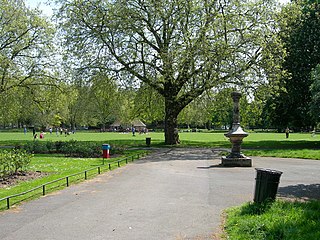
Kennington Park is a public park in Kennington, south London and lies between Kennington Park Road and St. Agnes Place. It was opened in 1854 on the site of what had been Kennington Common, where the Chartists gathered for their biggest "monster rally" on 10 April 1848. Soon after this demonstration the common was enclosed and, sponsored by the royal family, made into a public park.
Vauxhall Gardens is a public park in Kennington in the London Borough of Lambeth, England, on the south bank of the River Thames.

Kennington Road is a long straight road, approximately a mile in length, in the London Borough of Lambeth in London, England, running south from Westminster Bridge Road to Kennington Park Road.

St Michael's Church is the principal Anglican church for Camden Town in north London. The present building, built in the late 19th century, was designed by George Frederick Bodley and Thomas Garner in a Gothic Revival style.

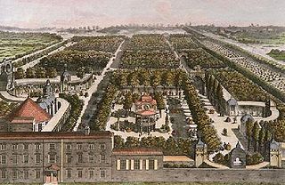
Royal Surrey Gardens were pleasure gardens in Newington, Surrey, London in the Victorian period, slightly east of The Oval. The gardens occupied about 15 acres (6.1 ha) to the east side of Kennington Park Road, including a lake of about 3 acres (1.2 ha). It was the site of Surrey Zoological Gardens and Surrey Music Hall.
Brixton Road is a road in the London Borough of Lambeth, leading from the Oval at Kennington to Brixton, where it forms the high street and then forks into Effra Road and Brixton Hill at St Matthew's church at the junction with Acre Lane and Coldharbour Lane. Brixton Market is located in Electric Avenue near Brixton Underground station and in a network of covered arcades adjacent to the two railway viaducts. The market arcades were declared listed buildings in 2009 following controversial proposals by Lambeth Council to replace them with a large US-style mall. The former "Brixton Oval" is at the southern end with Lambeth Town Hall, the Ritzy Cinema, the Brixton Tate Library and St Matthew's church. The space was renamed Windrush Square in 2010, in honour of the area's early Caribbean migrants and the HMT Empire Windrush, which in 1948 brought 492 passengers from Jamaica to London.

The A202 is a primary A road in London. It runs from New Cross Gate to London Victoria station. A section of the route forms a part of the London Inner Ring Road between Vauxhall and Victoria, known as Vauxhall Bridge Road.

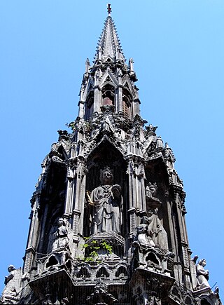
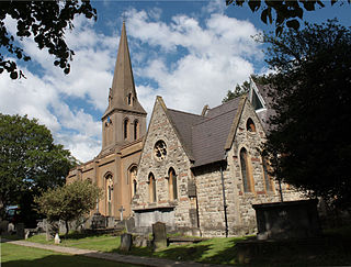
St John the Divine, Kennington, is an Anglican church in London. The parish of Kennington is within the Anglican Diocese of Southwark. The church was designed by the architect George Edmund Street in the Decorated Gothic style, and was built between 1871 and 1874. Today it is a grade I listed building.

Saint Augustine's, Kilburn, is a Church of England church in the area of Kilburn, in North London, United Kingdom. Because of its large size and ornate architecture, it is sometimes affectionately referred to as "the Cathedral of North London", although the church is not a cathedral in any official sense.
Prince's ward is an administrative division of the London Borough of Lambeth, England. It is located in the North of the borough, bounded by the River Thames on the west and Kennington Park Road on the east. It is made up of much of Kennington and Vauxhall.
Thomas Earp (1828–1893) was a British sculptor and architectural carver who was active in the late 19th century. His best known work is his 1863 reproduction of the Eleanor Cross which stands at Charing Cross in London. He specialised in sculpture for Gothic Revival churches and worked closely with the architect George Edmund Street in the 1860s and 1870s.
St Leonard's Church is a Church of England parish church in the London Borough of Lambeth. It is a Grade II listed building and occupies a prominent position on the west side of Streatham High Road, at its junction with Tooting Bec Gardens and Mitcham Lane.

St Anselm's Church is a Grade II listed church at 286 Kennington Road, Kennington, London SE11, built in 1932–33 by Stanley Davenport Adshead and Stanley Churchill Ramsey, on the foundations of an earlier church whose building was interrupted by the First World War; the present church is famously described as "barn-like".
St Mary's Gardens is an 18th-century garden triangle in Central London. The "square" is in the London Borough of Lambeth and has an unusual triangular shape. Since 1968 in planning policy it is a Conservation Area. Three rows of houses front its communal green, granted Grade II listed status under the statutory protective and recognition scheme in 1981.

