
Dudley is a market town in the West Midlands, England, 6 miles (9.7 km) southeast of Wolverhampton and 8 miles (13 km) northwest of Birmingham. Historically part of Worcestershire, the town is the administrative centre of the Metropolitan Borough of Dudley. In the 2011 census, it had a population of 79,379. The Metropolitan Borough, which includes the towns of Stourbridge and Halesowen, had a population of 312,900. In 2014, the borough council adopted a slogan describing Dudley as the capital of the Black Country, a title by which it had long been informally known.

The Metropolitan Borough of Dudley is a metropolitan borough of West Midlands, England. It was created in 1974 following the Local Government Act 1972, through a merger of the existing Dudley County Borough with the municipal boroughs of Stourbridge and Halesowen.

Castle Vale is a housing estate located between Erdington, Minworth and Castle Bromwich. Currently Castle Vale makes up the Castle Vale Ward of Birmingham City Council which is part of Erdington constituency, 6 miles (9 km) northeast of Birmingham city centre in England. The area has an approximate population of 10,000 people and has a distinctly modern residential character stemming from its history as a postwar overspill estate.
Wednesfield is a town and historic village in the City of Wolverhampton, West Midlands, England, It is 2 miles (3.2 km) east-northeast of Wolverhampton city centre and about 10 miles (16 km) from Birmingham and is part of the West Midlands conurbation. It was historically within the county of Staffordshire.

Penn is an area which is divided between the City of Wolverhampton and South Staffordshire district. The population of the Wolverhampton Ward taken at the 2011 census was 12,718. Originally, it was a village in the historic county of Staffordshire. There is considerable confusion about exactly which areas fall within Penn. In 19th century censuses, Merry Hill, Bradmore are understood to form part of Penn, although these areas are generally understood to be separate today. However, there has never been any doubt that the two historic settlements of Upper and Lower Penn form the core of the area.

Blakenhall is a suburb and ward in Wolverhampton, England. The population was 12,614 at the 2021 census.
Corstorphine is an area of the Scottish capital city of Edinburgh. Formerly a separate village and parish to the west of Edinburgh, it is now a suburb of the city, having been formally incorporated into it in 1920.

Gorey is a village in the parishes of St Martin and Grouville on the east coast of Jersey. The harbour is one of the three main harbours of the island, and is located in St Martin. The main centre of the village is located at Gorey Pier near Mont Orgeuil Castle, a 13th century fortification, in St Martin, while there is a small community with a few shops and restaurants. The church in the village is known as Gouray Church.
Goldthorn Park is a suburb of Wolverhampton, West Midlands. It is situated 1½ miles south of the city centre within the Blakenhall ward. It mostly consists of private houses built from the 1930s onwards.

Netherton is an area of the Metropolitan Borough of Dudley, 1.5 miles (2 km) south of Dudley town centre in the West Midlands of England, but historically in Worcestershire. Part of the Black Country, Netherton is bounded by nature reserves to the east and west, and an industrial area and the Dudley Southern By-Pass to the north.
Easterside is an area in the Ladgate ward of Middlesbrough, North Yorkshire, England. It is bounded to the east by Marton Road (A172) and by B1380 to the south. It had a population of 2,842 in 2011.
The Priory Estate is a housing estate in Dudley, West Midlands, England, which has largely been developed since 1929.
The Blue Coat School was a mixed secondary school located in Dudley, England. It was opened in 1869 within buildings in Bean Road, several hundred yards east of Dudley town centre. It expanded in 1970 to take in the buildings of Rosland Secondary School, Beechwood Road, at nearby Kates Hill, but the Bean Road site was still used for some lessons until 1981, when it was finally declared redundant after 112 years and sold to make way for a residential development.

Kates Hill, or Kate's Hill, is a residential area in Dudley, West Midlands, England.
Rosland Secondary School was a secondary school located in Dudley, England. It was built in 1932 to serve the expanding Kates Hill area of the town, and closed in 1970. Its buildings became part of The Blue Coat School, previously based several hundred yards away in Bean Road, until the entire school moved to the Rosland site in 1981.

Tipton Green is the central area of Tipton, a town in the West Midlands of England. It was heavily developed for heavy industry and housing during the 19th century, as Tipton was one of the most significant towns during the Industrial Revolution. Tipton Green is one of three electoral wards covering Tipton for Sandwell Metropolitan Borough Council. The population of this Sandwell ward taken at the 2011 census was 12,834. It is represented by three Labour councillors.
Cradley High School was a secondary school located in the Cradley area of Halesowen, which is a village in the West Midlands county of England. It is situated in the west end of Halesowen near the borders with Stourbridge and Brierley Hill, namely Homer Hill. As of 2006, the school had 606 pupils on roll.
Park Secondary School was a secondary school located in Dudley, West Midlands, England.
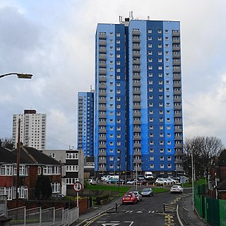
The Wren's Nest Estate is a housing estate located to the north west of the town centre of Dudley, West Midlands, England.
This article details a number of defunct schools that were once located in the Metropolitan Borough of Dudley. For details of currently operating schools in the area, please see: List of schools in Dudley.