
Offa's Dyke Path is a long-distance footpath loosely following the Wales–England border. Officially opened on 10 July 1971, by Lord Hunt, it is one of Britain's National Trails and draws walkers from throughout the world. About 60 miles (97 km) of the 177-mile (285 km) route either follows, or keeps close company with, the remnants of Offa's Dyke, an earthwork traditionally thought to have been constructed in the late 8th century on the orders of King Offa of Mercia.

Llangollen is a town and community, situated on the River Dee, in Denbighshire, Wales. Its riverside location forms the edge of the Berwyn range, and the Dee Valley section of the Clwydian Range and Dee Valley Area of Outstanding Natural Beauty, with the easternmost point of the Dee Valley Way being within the town. It had a population of 3,658 at the 2011 census.

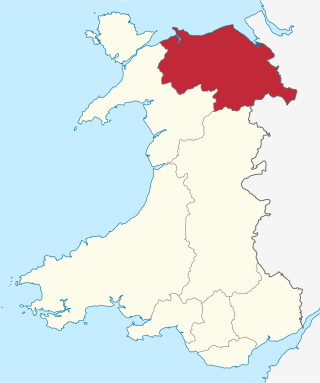
Denbighshire is a county in the north-east of Wales. Its borders differ from the historic county of the same name. This part of Wales contains the country's oldest known evidence of habitation – Pontnewydd (Bontnewydd-Llanelwy) Palaeolithic site has Neanderthal remains of some 225,000 years ago. Castles include Denbigh, Rhuddlan, Rhyl, Prestatyn, Trefnant, Llangollen and Ruthin, Castell Dinas Bran, Bodelwyddan and St Asaph Cathedral.
Clwyd is a preserved county of Wales, situated in the north-east corner of the country; it is named after the River Clwyd, which runs through the area. To the north lies the Irish Sea, with the English ceremonial counties of Cheshire to the east and Shropshire to the south-east. Powys and Gwynedd lie to the south and west respectively. Clwyd also shares a maritime boundary with Merseyside along the River Dee. Between 1974 and 1996, a slightly different area had a county council, with local government functions shared with six district councils. In 1996, Clwyd was abolished, and the new principal areas of Conwy County Borough, Denbighshire, Flintshire and Wrexham County Borough were created; under this reorganisation, "Clwyd" became a preserved county, with the name being retained for certain ceremonial functions.

The River Dee is a river in the United Kingdom. It flows through parts of both Wales and England, forming part of the border between the two countries.

Horseshoe Falls is a weir on the River Dee near Llantysilio Hall in Denbighshire, Wales, about 5 kilometres (3 mi) north-west of the town of Llangollen.

Chirk is a town and community in Wrexham County Borough, Wales, 10 miles south of Wrexham, between it and Oswestry. At the 2011 census, it had a population of 4,468. Historically in the traditional county of Denbighshire, and later Clwyd, it has been part of Wrexham County Borough since a local government reorganisation in 1996. The border with the English county of Shropshire is immediately south of the town, on the other side of the River Ceiriog.

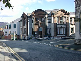
Wrexham County Borough is a county borough, with city status, in the north-east of Wales. It borders England to the east and south-east, Powys to the south-west, Denbighshire to the west and Flintshire to the north-west. The county borough has a population of 136,055. The city of Wrexham is its largest settlement, which together with villages such as Gwersyllt, New Broughton, Bradley and Rhostyllen form a built-up area with 65,692 residents. Villages in the county borough also include Ruabon, Rhosllanerchrugog, Johnstown, Acrefair, Bangor-on-Dee, and Coedpoeth amongst others. The county borough has two outlying towns, Chirk and Holt, and various rural settlements in the county borough's large salient in the Ceiriog Valley, and the English Maelor.
Glyndŵr was one of six local government districts in the county of Clwyd in Wales from 1974 to 1996.

Charles Frederick Beyer was a celebrated German-British locomotive designer and builder, and co-founder of the Institution of Mechanical Engineers. He was the co-founder and head engineer of Beyer, Peacock and Company in Gorton, Manchester. A philanthropist and deeply religious, he founded three parish churches in Gorton, was a governor of The Manchester Grammar School, and remains the single biggest donor to what is today the University of Manchester. He is buried in the graveyard of Llantysilio Church, Llantysilio, Llangollen, Denbighshire North Wales. Llantysilio Church is within the grounds of his former 700 acre Llantysilio Hall estate. His mansion house, built 1872–1874, is nearby.

Overton or Overton-on-Dee is a village and community in Wrexham County Borough, Wales. It is situated close to the Welsh-English border on the edge of an escarpment that winds its way around the course of the River Dee, from which Overton-on-Dee derives its name.

Berwyn railway station in Denbighshire, Wales, is a railway station on the former cross-country line between Ruabon and Barmouth. The station, which opened in May 1865, was a stop on the Great Western Railway (GWR) line between Llangollen and Corwen. It was closed by British Rail in January 1965.

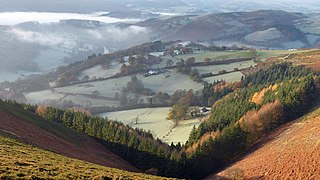
The Eglwyseg valley is an area to the north east of Llangollen in Denbighshire, Wales; it is within the boundaries of Llantysilio Community. The name also refers to a widely scattered hamlet in the valley.

Henry Robertson was a Scottish mining engineer and prolific railway builder, industrialist and Liberal Party politician. He was head of Brymbo Steelworks, Wrexham. He was co-founder of Beyer-Peacock, with Charles Beyer, and Richard Peacock. His son Sir Henry Beyer Robertson was knighted by Queen Victoria for the achievements of his father.

Moel y Gamelin is a hill in Denbighshire, North Wales, to the northwest of the town of Llangollen. It is the highest summit of a range which stretches eastwards from near the village of Carrog to the Horseshoe Pass traversed by the A542 road, and reaches an elevation of 577 metres (1,893 ft) above sea level. The western part of the range is known as Llantysilio Mountain whilst the eastern end is referred to as Maesyrchen Mountain. At its top is a round cairn, of unknown date, measuring about 30 metres (100 ft) in diameter and 1.8 metres (6 ft) high. It is in the Clwydian Range and Dee Valley Area of Outstanding Natural Beauty.

Llantysilio Hall is a Grade II* listed country house in Llantysilio, near Llangollen in Denbighshire. It is on the bank of the River Dee and adjacent to the historic Horseshoe Falls, the source of the Llangollen Canal.

The Chain Bridge is a footbridge over the River Dee at Berwyn, Llangollen, Denbighshire, north Wales.
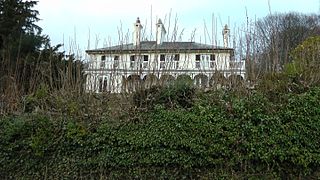
Bryntysilio Hall is a country house in Llantysilio, Denbighshire, north Wales, two miles west of Llangollen. It was the summer residence of Sir Theodore Martin, the author of Life of The Prince Consort, the official biography of Prince Albert, and of his wife, Shakespearean actress Lady Martin. Sir Theodore wrote most of the book whilst at Bryntysilio, which was their summer residence. He was knighted for his work and became a close friend of Queen Victoria. It was written 1874-1880. On 26 August 1889, during Victoria's visit to North Wales, she visited Bryntysilio Hall and took tea there. Sir Theodore showed the queen the writing desk where most of the work was written.
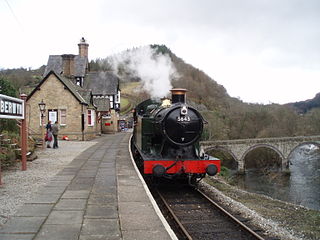
Berwyn is a settlement in Denbighshire, Wales. The settlement is situated a mile north-west of Llangollen and is adjacent to the River Dee. The Horseshoe Falls is nearby. Berwyn has a station on the Llangollen Railway.
The Clwydian Range and Dee Valley is a designated Area of Outstanding Natural Beauty (AONB) and proposed national park, located in north-east Wales, covering the Clwydian Range, and the valley of the River Dee. Designated in 1985 as the Clwydian Range AONB, and expanded to its current form in 2011, the Area of Outstanding Natural Beauty includes: medieval field systems, open heather moorland, prehistoric hillforts, limestone crags, broad leaved woodland, wooded valleys, and farmland. In 2018, an estimated 1.1 million people visited six key sites across the AONB, generating approximately £24.1 million to the Welsh economy, according to Natural Resources Wales. The AONB falls within the jurisdiction of the local authorities of Denbighshire, Flintshire, and Wrexham County Borough, with the majority, 80% of the AONB in Denbighshire, and the remaining 20% split evenly between the other two authorities. The AONB is the largest of only five AONBs in Wales, and one of the 46 in the United Kingdom. Additionally, it is one of only 8 protected areas of Wales. Long-distance footpaths; Offa's Dyke Path, and the Clwydian Way pass through the AONB. The area of the Clwydian Range and Dee Valley AONB is 390 km2 (150 sq mi), and has been proposed by the Welsh Government to become Wales' fourth national park.


