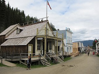
Barkerville was the main town of the Cariboo Gold Rush in British Columbia, Canada, and is preserved as a historic town. It is located on the north slope of the Cariboo Plateau near the Cariboo Mountains 80 kilometres (50 mi) east of Quesnel. BC Highway 26, which follows the route of the Cariboo Wagon Road, the original access to Barkerville, goes through it.

Lillooet, formerly Cayoosh Flat, is a community on the Fraser River in British Columbia, Canada, about 240 km (150 mi) up the British Columbia Railway line from Vancouver. Situated at an intersection of deep gorges in the lee of the Coast Mountains, it has a dry climate with an average of 329.5 mm (12.97 in) of precipitation being recorded annually. Lillooet has a long growing season, and once had prolific market gardens and orchard produce. It often vies with Lytton and Osoyoos for the title of "Canada's Hot Spot" on a daily basis in summer.
Highway 26, also known as the Barkerville Highway, is a minor east-west highway in the North Cariboo region of the Central Interior of British Columbia, Canada. First opened in 1967, it provides access to the community of Wells and the famous gold rush town of Barkerville at the foot of the Cariboo Mountains, respectively 75 and 81 km east of the highway's junction with Highway 97 at Quesnel. Also accessed by the route is Bowron Lakes Provincial Park, a popular canoeing expedition circuit, the cutoff for which is between Barkerville and Wells. Since Highway 26 is very lightly travelled, it has not needed any major improvements since its opening. Its route is approximately the same as that of the Cariboo Wagon Road.

The Cariboo is an intermontane region of British Columbia, Canada, centered on a plateau stretching from Fraser Canyon to the Cariboo Mountains. The name is a reference to the caribou that were once abundant in the region.
Yale is an unincorporated town in the Canadian province of British Columbia.

The Cariboo Road was a project initiated in 1860 by the Governor of the Colony of British Columbia, James Douglas. It involved a feat of engineering stretching from Fort Yale to Barkerville, B.C. through extremely hazardous canyon territory in the Interior of British Columbia.
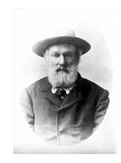
William Barker (1817–1894), also known as Billy Barker, was an English prospector who was famous for being one of the first to find a large amount of gold in the Cariboo of British Columbia. He was also the founder and namesake of Barkerville, the most significant town during the region's gold rush, which is preserved today as a historic town.

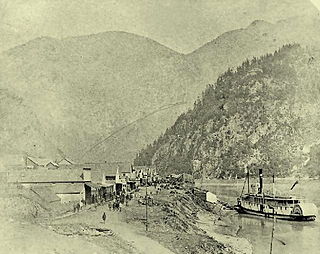
The Cariboo Gold Rush was a gold rush in the Colony of British Columbia, which later joined the Canadian province of British Columbia. The first gold discovery was made at Hills Bar in 1858, followed by more strikes in 1859 on the Horsefly River, and on Keithley Creek and Antler Creek in 1860. The actual rush did not begin until 1861, when these discoveries were widely publicized. By 1865, following the strikes along Williams Creek, the rush was in full swing.

The Cariboo Plateau is a volcanic plateau in south-central British Columbia, Canada. It is part of the Fraser Plateau that itself is a northward extension of the North American Plateau. The southern limit of the plateau is the Bonaparte River although some definitions include the Bonaparte Plateau between that river and the Thompson, but it properly is a subdivision of the Thompson Plateau. The portion of the Fraser Plateau west of the Fraser River is properly known as the Chilcotin Plateau but is often mistakenly considered to be part of the Cariboo Plateau, which is east of the Fraser.

Herbert Sylvester Sincock was a left-handed pitcher in Major League Baseball. In 1908, he played both college baseball at the University of Michigan and professional baseball for the Cincinnati Reds.

Alexandria or Fort Alexandria is a National Historic Site of Canada on the Fraser River in British Columbia, and was the end of the Old Cariboo Road and the Cariboo Wagon Road. It is located on Highway 97, 103 miles (166 km) north of 100 Mile House and 28 miles (45 km) south of Quesnel.

Quesnel Forks, historically Quesnelle Forks, also simply known as "The Forks" or grandly known as "Quesnel City" is a ghost town in the Cariboo region of British Columbia, Canada. It is located the junction of the Quesnel and Cariboo Rivers and is 60 km southeast of Quesnel and only 11 km northwest of Likely.
Lac La Hache is a recreational and retirement community in the Cariboo region of British Columbia, Canada. Located on the shore of Lac La Hache alongside British Columbia Highway 97 near the regional centre of 100 Mile House, the community's origins date to the days of the Cariboo Gold Rush and the Cariboo Wagon Road, for which it provided an important roadhouse. Lac La Hache, or "The Lake of the Axe" as it translates to, was named, during the fur trade era, after the unfortunate incident of a French-Canadian voyageur who lost his axe head while chopping a hole in the ice. It is a town rich in history, as it sits along the Gold Rush Trail.

Williams Creek is an important historical gold mining creek in the Cariboo goldfields of the Central Interior of British Columbia, entering the Willow River between Barkerville and the town of Wells, which is at the headwaters of the Willow River.
Cottonwood River is a tributary of the Fraser River in the Central Interior of British Columbia, Canada. Rising at the confluence of the Swift River and Lightning Creek at Coldspring House in the Cariboo goldfields of the northern Cariboo Plateau, it flows northwest and then turns southwest to join the Fraser just north of the city of Quesnel, which is at the confluence of the Quesnel River with the Fraser.

Cottonwood, including the Cottonwood Ranch and Cottonwood House, is an unincorporated settlement in the North Cariboo region of the Central Interior of British Columbia, Canada. Originally a ranch, it is located in the northern Cariboo Plateau, just 8 km northwest of Coldspring House, which is at the confluence of the Swift River and Lightning Creek, which is the beginning of the Cottonwood River. Lightning Creek was one of the more famous of the gold-bearing creeks of the Cariboo Gold Rush.
Coldspring House is an unincorporated locality and former roadhouse on the Cariboo Wagon Road in the Cariboo Country of the Central Interior of British Columbia, Canada. Located just east of the confluence of Lightning Creek and the Swift River between Quesnel and Barkerville along that route. Only 8 km east along that road from Cottonwood House, another roadhouse still operating as a store and campground today, as well as a provincial heritage property with a small museum. Just farther along the route, which is today's BC Highway 26, is Beaver Pass House. All date from the era of the Cariboo Gold Rush and were busy stopping places for travellers going to and from the goldfields.
Fanny Bendixen was a hotelier and saloon–keeper during the gold–rush period in British Columbia.
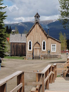
St. Saviour's Anglican Church is an historic one-storey rustic Carpenter Gothic Anglican church building located in the National Historic Site of Barkerville, British Columbia. Designed by the Rev. James Reynard, it was built by John Bruce and J. G. Mann. Construction began in 1868 but was not finished until after the church's first service was held on September 18, 1870. Its Carpenter Gothic architectural features include lancet windows and board and batten walls on the exterior as well as interior. A porch on the right side which appeared in early photographs is no longer in existence. Today it is part of Barkerville Historic Town and admission to the church is included in the price of admission to the town. Lay services are conducted in the church most days during the summer season.
William Allen Jones was a Canadian dentist and miner. He was the first practicing dentist in British Columbia under the British Columbia Dental Act.