Starokadomsky Island

Last updated
Starokadomsky Island
Russian: Остров Старокадомского
Maly Taymyr-Operational Navigation Chart B-3, 2nd edition.jpg
Starokadomsky and Maly Taymyr Island
Kara sea2ST.PNG
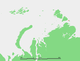
Location of the island in the Laptev Sea
Geography
Location Laptev Sea
Coordinates 78°15′N106°31′E / 78.250°N 106.517°E / 78.250; 106.517
Archipelago Severnaya Zemlya
Area110 km2 (42 sq mi)
Length18 km (11.2 mi)
Width7 km (4.3 mi)
Highest elevation39 m (128 ft)
Administration

Starokadomsky Island (Russian : Остров Старокадомского; Ostrov Starokadomskogo) is an hourglass-shaped island in the Laptev Sea, Russian Arctic.

Russian language East Slavic language

Russian is an East Slavic language, which is official in the Russian Federation, Belarus, Kazakhstan and Kyrgyzstan, as well as being widely used throughout Eastern Europe, the Baltic states, the Caucasus and Central Asia. It was the de facto language of the Soviet Union until its dissolution on 25 December 1991. Although, nowadays, over two decades after the breakup of the Soviet Union, Russian is used in official capacity or in public life in all the post-Soviet nation-states, as well as in Israel and Mongolia, the rise of state-specific varieties of this language tends to be strongly denied in Russia, in line with the Russian World ideology.

Laptev Sea Marginal sea in the Arctic Ocean north of Siberia between the Kara Sea and the East Siberian Sea

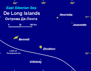
The Laptev Sea is a marginal sea of the Arctic Ocean. It is located between the northern coast of Siberia, the Taimyr Peninsula, Severnaya Zemlya and the New Siberian Islands. Its northern boundary passes from the Arctic Cape to a point with co-ordinates of 79°N and 139°E, and ends at the Anisiy Cape. The Kara Sea lies to the west, the East Siberian Sea to the east.

Contents

Geography

Starokadomsky Island is located off the southeastern end of the Severnaya Zemlya archipelago and northeast of the Taymyr Peninsula. Maly Taymyr Island lies on its southeastern side, separated by a 6 km wide sound.

Severnaya Zemlya Archipelago in Krasnoyarsk Krai, Russian Federation

Severnaya Zemlya is a 37,000-square-kilometre (14,000-square-mile) archipelago in the Russian high Arctic. It lies off Siberia's Taymyr Peninsula, separated from the mainland by the Vilkitsky Strait. This archipelago separates two marginal seas of the Arctic Ocean, the Kara Sea in the west and the Laptev Sea in the east.

Taymyr Peninsula peninsula

The Taymyr Peninsula is a peninsula in the Far North of Russia, in the Siberian Federal District, that forms the northernmost part of the mainland of Eurasia. Administratively it is part of the Krasnoyarsk Krai Federal subject of Russia.

Maly Taymyr Island Russian island in the Arctic Ocean

Maly Taymyr Island is an island in the Laptev Sea, Russian Arctic.

The maximum length of Starokadomsky Island is 18 km and its maximum width only 7 km. It is surrounded by narrow beach ridges and swales. The small detached islands off Starokadomsky's northern end are known as Mayskiye Ostrova. Ostrov Vesenniy is the easternmost one.

Beach ridge Wave-swept or wave-deposited ridge running parallel to a shoreline

A beach ridge is a wave-swept or wave-deposited ridge running parallel to a shoreline. It is commonly composed of sand as well as sediment worked from underlying beach material. The movement of sediment by wave action is called littoral transport. Movement of material parallel to the shoreline is called longshore transport. Movement perpendicular to the shore is called on-offshore transport. A beach ridge may be capped by, or associated with, sand dunes. The height of a beach ridge is affected by wave size and energy.

Swale (landform) low tract of land

A swale is a shallow channel with gently sloping sides. A swale may be either natural or man-made. Artificial swales are often infiltration basins, designed to manage water runoff, filter pollutants, and increase rainwater infiltration.

The Vilkitsky Strait runs south of Starokadomsky and Maly Taymyr. Its waters, as well as the waters surrounding the two islands, are covered with pack ice during the long and bitter winters. There are many ice floes even in the short summer, between June and September.

Vilkitsky Strait strait

Vilkitsky Strait is a strait between the Taimyr Peninsula and Bolshevik Island in the Severnaya Zemlya archipelago. The strait connects the Kara and Laptev Seas. The length of the Vilkitsky Strait is 128 km, the width approx. 55 km and the depth between 32 m and 210 m. It is covered with drifting ice all year round. The strait was discovered in 1913 by a Russian hydrographic expedition led by Boris Vilkitsky and then named after him in 1918.

History

Starokadomsky Island was discovered in 1913 by Boris Vilkitsky in the course of the Arctic Ocean Hydrographic Expedition. [1] It was named after Dr. Leonid Starokadomsky, one of the leaders of the Arctic Ocean Hydrographic Expedition. [2] [3] [4]

Boris Vilkitsky Russian polar explorer

Boris Andreyevich Vilkitsky was a Russian hydrographer and surveyor. He was the son of Andrey Ippolitovich Vilkitsky.

Arctic Ocean Hydrographic Expedition

The Arctic Ocean Hydrographic Expedition (GESLO) (1910–1915) was a scientific expedition organized by Russia for the purpose of the development of the Northern Sea Route.

In present times Starokadomsky Island belongs to the Krasnoyarsk Krai administrative division of the Russian Federation and is part of the Great Arctic State Nature Reserve – the largest nature reserve of Russia and one of the biggest in the world. [5]

Krasnoyarsk Krai First-level administrative division of Russia

Krasnoyarsk Krai is a federal subject of Russia, with its administrative center in the city of Krasnoyarsk—the third-largest city in Siberia. Comprising half of the Siberian Federal District, Krasnoyarsk Krai is the largest krai in the Russian Federation, the second largest federal subject and the third largest subnational governing body by area in the world, after Sakha and the Australian state of Western Australia. The krai covers an area of 2,339,700 square kilometers (903,400 sq mi), which is nearly one quarter the size of the entire country of Canada, constituting roughly 13% of the Russian Federation's total area and containing a population of 2,828,187, or just under 2% of its population, per the 2010 Census.

Great Arctic State Nature Reserve nature reserve in Russia

The Great Arctic State Nature Reserve is a nature reserve in Krasnoyarsk Krai, Russia. With an area of 41,692 square kilometers (16,097 sq mi), it is the largest reserve of Russia and Eurasia, as well as one of the largest in the world.

See also

Related Research Articles

October Revolution Island island

October Revolution Island is the largest island of the Severnaya Zemlya group in the Russian Arctic.

Bolshevik Island island

Bolshevik Island is an island in Severnaya Zemlya, Krasnoyarsk Krai, Russian Arctic.

Vilkitsky Island (East Siberian Sea) island in Russia

Vilkitsky Island is the southernmost island of the De Long group in the northern part of the East Siberian Sea. Administratively Vilkitsky Island belongs to the Sakha Republic administrative division of the Russian Federation.

Vilkitsky Island (Kara Sea) island

Vilkitsky Island, is an island in the Kara Sea. It is located 40 km northeast of Shokalskogo Island, off the tip of the Gydan Peninsula in North Siberia.

Plavnikovye Islands

The Plavnikovye Islands is a group of islands, in the Kara Sea eastern region, off the coast of Siberia. These islands are covered with tundra vegetation and there are many lakes and swamps. They are under snow and ice during most of the year.

Komsomolskaya Pravda Islands Island group in Krasnoyarsk Krai, Russian Federation

The Komsomolskaya Pravda Islands are an archipelago in the far north of the Russian Federation. The islands are uninhabited and are covered with tundra vegetation, shingle and ice.

Kolchak Island island in Russia

Kolchak Island or Kolchaka Island, is an island in the Kara Sea located in a coastal area of skerries NE of the Shturmanov Peninsula. It is near the southern end of the Nordenskiöld Archipelago, but not geographically part of it.

Heiberg Islands island group

The Heiberg Islands, spelt Geyberg, Gejberg or Geiberg is a group of four small islands covered with tundra vegetation and with scattered stones on their shores. They lie in the Kara Sea, between the bleak coast of Siberia's Taymyr Peninsula and Severnaya Zemlya. These islands are between 35 and 45 km from the continental shore.

Firnley Islands

The Firnley Islands is a group of three small islands covered with tundra vegetation and with scattered stones on their shores. They lie in the Kara Sea, close to the bleak coast of Siberia's Taymyr Peninsula, not far east of the Nordenskjold Archipelago. These islands lie about 35 km from the continental shore.

<i>Taymyr</i> (1909 icebreaker) steam-powered icebreaker

The Taymyr was an icebreaking steamer of 1200 tons built for the Russian Imperial Navy at St. Petersburg in 1909. It was named after the Taymyr Peninsula.

<i>Vaygach</i> (1909 icebreaker)

Icebreaker Vaygach was an icebreaking steamer of moderate size built for the Russian Imperial Navy at St. Petersburg in 1909. She was named after Vaygach Island in the Russian Arctic.

Hovgaard Island (Kara Sea)

Hovgaard Island is an island of the Nordenskiöld Archipelago in the Kara Sea, off the coast of Siberia.

Cape Neupokoyev

Cape Neupokoyev is a headland in Severnaya Zemlya, Russia.

Akhmatov Fjord

Akhmatov Fjord, also known as Akhmatov Bay, is a fjord in Severnaya Zemlya, Krasnoyarsk Krai, Russia. This fjord is clogged by ice most of the year.

Marat Fjord

Marat Fjord, is a fjord in Severnaya Zemlya, Krasnoyarsk Krai, Russia. It is blocked by ice most of the year.

References