In Canada, an Indian reserve is specified by the Indian Act as a "tract of land, the legal title to which is vested in Her Majesty, that has been set apart by Her Majesty for the use and benefit of a band."
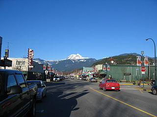
Squamish is a community and a district municipality in the Canadian province of British Columbia, located at the north end of Howe Sound on the Sea to Sky Highway. The population of the Squamish census agglomeration – including First Nation reserves of the Squamish Nation not governed by the municipality – is 19,893.

The Squamish-Lillooet Regional District is a quasi-municipal administrative area in British Columbia, Canada. It stretches from Britannia Beach in the south to Pavilion in the north. Lillooet, Pemberton, Whistler and Squamish are the four municipalities in the regional district. Its administrative offices are in the Village of Pemberton, although the district municipalities of Squamish, Whistler, and Lillooet are all larger population centres. The district covers 16,353.68 km² of land area.

Greater Vancouver, also known as Metro Vancouver, is the metropolitan area with its major urban centre being the city of Vancouver, British Columbia, Canada. The term "Greater Vancouver" is roughly coterminous with the geographic area governed by the Metro Vancouver Regional District, though it predates the 1966 creation of the regional district. It is often used to include areas beyond the boundaries of the regional district but does not generally include wilderness and agricultural areas within that regional district.

The Musqueam Indian Band is a First Nations band government in the Canadian province of British Columbia and is the only First Nations band whose reserve community lies within the boundaries of the City of Vancouver.

The Skeena-Queen Charlotte Regional District is a quasi-municipal administrative area in British Columbia. It is located on British Columbia's west coast and includes Haida Gwaii, the largest of which are Graham Island and Moresby Island. Its administrative offices are in the City of Prince Rupert.
Mount Currie is a small, mostly First Nations, community in British Columbia, 164 kilometres north of Vancouver and 40 kilometres north-east of Whistler along Highway 99. "The Mount Currie settlement and mountain were named after Scottish settler John Currie, who located to Quebec in 1851. After failure as a gold seeker in California and the Cariboo, Currie turned to ranching and finally settled near Pemberton with his Lillooet Indian wife in 1885." The area is traditional territory of the Lil'wat, a subgroup of the St'at'imc people who with the communities of Skatin, Samahquam and Xa'xtsa to the south comprise the Lower St'at'imc or Lower Lillooet. The Mount Currie Indian Reserve hosts most of the population of Mount Currie, who are known as the Lil'wat, their name for the spot, but west of the reserve there are non-native farms, industrial sites and tourist resorts, and on the mountain shoulder immediately north of the reserve is Owl Creek, the site of the original Catholic mission school which drew the Lil'wat from their former homebase at Pemberton Meadows so as to be close to their children. Owl Creek today is the name of a modern subdivision of mostly non-natives, though Owl Creek remains on the rail crossing on the CNR just outside the reserve.
Spuzzum First Nation is a Nlaka'pamux First Nations government located near Spuzzum, British Columbia. It is a member of the Fraser Canyon Indian Administration, one of three tribal councils of the Nlaka'pamux people. Other members of the Fraser Canyon Indian Administration are the Kanaka Bar, Skuppah and Nicomen First Nations.
The Squamish people are an indigenous people in southwestern British Columbia, Canada. In 2012, there was population of 3,893 band members registered with the Squamish Nation. Their language is the Squamish language or Sḵwx̱wú7mesh snichim, considered a part of the Coast Salish languages, and is categorized as nearly extinct with just 10 fluent speakers as of 2010. The traditional territory covered Point Grey as the southern border. From here, it continued northward to Roberts Creek on the Sunshine Coast, up the Howe Sound. The northern part included the Squamish, Cheakamus, Elaho and Mamquam rivers. Up the Cheakamus River it included land past Whistler, British Columbia. The southern and eastern part of their territory includes Indian Arm, along Burrard Inlet, through False Creek then English Bay and Point Grey. Today the Squamish people live mostly in seven communities, located in West Vancouver, North Vancouver, and within and nearby to the District of Squamish.

The Lil'wat First Nation, a.k.a. the Lil'wat Nation or the Mount Currie Indian Band, is a First Nation band government located in the southern Coast Mountains region of the Interior of the Canadian province of British Columbia. It is a member of the Lillooet Tribal Council, which is the largest grouping of band governments of the St'at'imc or Stl'atl'imx people. Other St'at'imc governments include the smaller In-SHUCK-ch Nation on the lower Lillooet River to the southwest, and the independent N'quatqua First Nation at the near end of Anderson Lake from Mount Currie, which is the main reserve of the Lil'wat First Nation, and also one of the largest Indian reserves by population in Canada.
August Jack was an Indigenous/Aboriginal chief of the Squamish people. He was born in the village of Xwayxway on the peninsula that is now Stanley Park, Vancouver, or at Chaythoos, British Columbia, Canada and the son of Supple Jack "Khay- Tulk" of Chaythoos and Sally "Owhaywat" from the Yekwaupsum Reserve north of Squamish, British Columbia. His grandfather was Chief Khahtsahlano of Senakw who had migrated from his home at Toktakanmic on the Squamish River to Chaythoos, and the man from whom he inherited his name. The suffix "lan-ogh" in their name means "man".
Chiyakmesh is a community of the Indigenous Squamish people, located near Squamish, British Columbia. The name of the Cheakamus River comes from the name of this community, which is located on Cheakamus Indian Reserve No. 11. Chiyakamesh translates into People of the Fish Weir. A chiyak is a special fish weir this community used on the Cheakamus River to catch salmon. It is the largest reserve of the Squamish Nation in size.

Ustlawn is a Squamish village community located on the shores of North Vancouver. The Squamish name Eslhá7an translates as head bay, denoted what used to be the farthest out reaching bay enclave in the Burrard Inlet. Its origin as a primary village goes back to the earliest missionaries in British Columbia with the St.Paul's Catholic Church being the oldest extant church in British Columbia, and a National Historic Site of Canada. It is also home to the Eslha7an Training Center, the Stitsma Employment Center, and the So-Sah-Latch Health and Family Centre. On the shores of the village is the Mosquito Creek Marina. The official name of the Indian Reserve it is situated on is Mission Indian Reserve No. 1.
Tsinstikeptum 10, usually referred to as Tsinstikeptum Indian Reserve No. 10, is one of two Indian Reserves of the Westbank First Nation located in West Kelowna, British Columbia, Canada. It and Tsinstikeptum Indian Reserve No. 9 are jointly normally referred to as the Westbank Indian Reserve. Tsinstikeptum Indian Reserve No. 10, which is 339 ha. in area, is located opposite the City of Kelowna proper, across Okanagan Lake.
The following is an alphabetical list of topics related to Indigenous peoples in Canada, comprising the First Nations, Inuit and Métis peoples.

Seine River First Nation, previously known as the Rivière la Seine Band, is an Ojibwe First Nation reserve located roughly 300 kilometres (190 mi) west of Thunder Bay, Ontario. As of November 2011, the First Nation had a total registered population of 725, of which 327 lived on their own reserve.
