Meland is a municipality in the Nordhordland district of Hordaland county, Norway. The municipality lies about 30 minutes north of the city of Bergen in Western Norway. The island municipality sits mostly on the island of Holsnøy, where the administrative centre of Frekhaug is located. Other villages in Meland include Hjartås, Holme, Io, Krossneset, Meland, and Rossland.

Sunndal (help·info) is a municipality in the Nordmøre region located in the northeast part of Møre og Romsdal county, Norway. The administrative center of the municipality is the village of Sunndalsøra. Other villages include Gjøra, Grøa, Hoelsand, Jordalsgrenda, Romfo, Ålvund, Ålvundeidet, and Øksendalsøra. With an area of 1,712 square kilometres (661 sq mi), it is the largest municipality in Møre og Romsdal county. The important occupations in Sunndal include industry, public services, retail, and farming.

Halsa is a municipality in Møre og Romsdal county, Norway. It is part of the Nordmøre region. The administrative centre of Halsa is the village of Liabøen. Other villages in the municipality include Todalen, Halsanaustan, Valsøyfjord, Engan, Hjellnes, and Valsøybotnen.

Nesset is a municipality in Møre og Romsdal county, Norway on the Romsdal Peninsula. The administrative centre is the village of Eidsvåg. Other population centers include Rausand, Boggestranda, Myklebostad, Eresfjord, and Eikesdalen.

Eide is a municipality in Møre og Romsdal county, Norway. It is part of the region of Nordmøre. It is located on the Romsdal peninsula, along the Kornstadfjorden and the Kvernesfjorden. The administrative centre of the municipality is the village of Eide. Other villages include Lyngstad, Vevang, and Visnes.

Gjemnes is a municipality in Møre og Romsdal county, Norway on the Romsdal peninsula. It is part of the Nordmøre region. The administrative centre is the village of Batnfjordsøra, which lies along the Batnfjorden and it is a former steamship landing place. Other villages in Gjemnes include Torvikbukt, Flemma, Angvika, Gjemnes, Øre, and Osmarka.

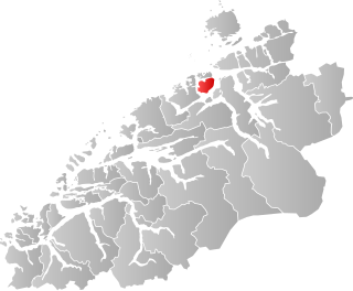
Tingvoll is a municipality in Møre og Romsdal county, Norway. It is part of the Nordmøre region. The administrative centre is the village of Tingvollvågen. Other villages include Meisingset, Kvisvik, and Torjulvågen. The municipality covers a peninsula on the mainland as well as a few surrounding islands. Norwegian National Road 70 and European route E39 both run through the municipality.

Dønnes is a former municipality in the Helgeland traditional region in Nordland county, Norway. The 88-square-kilometre (34 sq mi) municipality existed from 1888 until its dissolution in 1962. The former municipality encompassed the northern part of the island of Dønna, the western parts of the islands of Tomma and Løkta, and over 300 smaller surrounding islands, islets, and skerries.
Straumsnes may refer to the following locations:

Bolsøy is a former municipality in Møre og Romsdal county, Norway. Bolsøy encompassed the area around the Fannefjorden including most of the present-day Molde Municipality, excluding the town of Molde. The municipality also included the Molde Archipelago and the island of Bolsøya. The administrative center of the municipality was located on the island of Bolsøya near the main church for the parish, Bolsøy Church, was also located.

Øre is a village and former municipality in Møre og Romsdal county, Norway. The village is located along the Batnfjorden in the present-day Gjemnes Municipality. The village lies about half-way between the villages of Batnfjordsøra and Torvikbukt. Øre Church is located in this village. The village of Øre was the administrative centre of the old Øre Municipality which existed from 1838 until 1965.
Stangvik is a village and former municipality in Møre og Romsdal county, Norway. The village is located along the Stangvikfjorden in the present-day Surnadal Municipality, about 20 kilometres (12 mi) southwest of the villages of Surnadalsøra and Skei. The village is home to Stangvik Church.

Tingvoll Church is a parish church in Tingvoll Municipality in Møre og Romsdal county, Norway. It is located in the village of Tingvollvågen. The church is the main church of the Tingvoll parish, in the Indre Nordmøre deanery in the Diocese of Møre.
Freifjorden is a fjord in the municipalities of Kristiansund, Tingvoll, and Gjemnes in Møre og Romsdal county, Norway. The 14-kilometre (8.7 mi) long fjord begins near the island of Tustna and flows southwest between the islands of Nordlandet and Frei on the west side and the mainland peninsula of Straumsnes and the islands of Aspøya and Bergsøya on the east side. The Kvernesfjorden lies at the west end of the Freifjorden, near the Freifjord Tunnel. The villages of Nedre Frei and Kvalvåg are located on the western shore of the fjord.

Bergsøya is an island in Gjemnes Municipality in Møre og Romsdal county, Norway. The island is located near the junctions of the Freifjorden, Kvernesfjorden, and Tingvollfjorden. The highest point on the 8.7-square-kilometre (3.4 sq mi) island is the 278-metre (912 ft) tall mountain Varden.

Tingvollvågen or Tingvoll is the administrative centre of Tingvoll Municipality in Møre og Romsdal county, Norway. The village is located on a small inlet off the Tingvollfjorden, directly across the fjord from the village of Angvika. Tingvollvågen lies about 10 kilometres (6.2 mi) north of Meisingset and about 20 kilometres (12 mi) south of Straumsnes. The historic Tingvoll Church is located in this village. Norwegian National Road 70 runs through the village on its way from Kristiansund to Oppdal.

Straumsnes Church is a parish church in Tingvoll Municipality in Møre og Romsdal county, Norway. It is located in the village of Straumsnes. The church is part of the Straumsnes parish in the Indre Nordmøre deanery in the Diocese of Møre. The white, wooden church was built in 1864 by the architect Gustav Olsen. The church seats about 300 people and it serves the northern part of the municipality.

Dverberg is a former municipality in Nordland county, Norway. The municipality existed from 1838 until its dissolution in 1964. The municipality encompassed areas on the island of Andøya in what is now Andøy Municipality. Starting out at about 616 square kilometres (238 sq mi) in 1838, it was reduced in size in 1924. Upon its dissolution in 1964, the municipality was only 279 square kilometres (108 sq mi). The administrative centre was the village of Dverberg where Dverberg Church is located.