
Shropshire (; alternatively Salop; abbreviated, in print only, Shrops; demonym Salopiansə-LOH-pee-ən, is a county in England, bordering Wales to the west, Cheshire to the north, Staffordshire to the east, and Worcestershire and Herefordshire to the south. Shropshire Council was created in 2009, a unitary authority taking over from the previous county council and five district councils. The borough of Telford and Wrekin has been a separate unitary authority since 1998 but continues to be included in the ceremonial county.

Church Stretton is a market town in Shropshire, England, 13 miles (21 km) south of Shrewsbury and 15 miles (24 km) north of Ludlow. The population in 2011 was 4,671.
Bourton-on-the-Water is a village and civil parish in Gloucestershire, England that lies on a wide flat vale within the Cotswolds Area of Outstanding Natural Beauty. The village had a population of 3,296 inhabitants at the 2011 census. Much of the village core is a designated Conservation Area.

Much Wenlock is a town and parish in Shropshire, England, situated on the A458 road between Shrewsbury and Bridgnorth. Nearby, to the northeast, is the Ironbridge Gorge, and the new town of Telford. The civil parish includes the villages of Homer, Wyke, Atterley, Stretton Westwood and Bourton. The population of the civil parish, according to the 2001 census, was 2,605, increasing to 2,877 at the 2011 Census. Notable historic attractions in the town are Wenlock Priory and the Guildhall.

Craven Arms is a market town and civil parish in Shropshire, England, on the A49 road and the Welsh Marches railway line, which link it north and south to the larger towns of Shrewsbury and Ludlow respectively. The Heart of Wales railway line joins the Welsh Marches line at Craven Arms and the town is served by Craven Arms railway station. The town is enclosed to the north by the Shropshire Hills Area of Outstanding Natural Beauty, and to the south is the fortified manor house of Stokesay Castle.

Wenlock Edge is a limestone escarpment near Much Wenlock, Shropshire, England and a site of special scientific interest because of its geology. It is over 19 mi (31 km) long, running southwest to northeast between Craven Arms and Much Wenlock, and is roughly 1,083 feet above sea level. The deciduous woodland which runs along it covers much of the steep slopes of the escarpment and in parts it is very well preserved.

All Stretton is a village and civil parish in Shropshire, England.

Northleach is a market town in Northleach with Eastington civil parish in Gloucestershire, England. The town is in the valley of the River Leach in the Cotswolds, about 10 miles (16 km) northeast of Cirencester and 11 miles (18 km) east-southeast of Cheltenham. The 2011 Census recorded the parish's population as 1,854.

Church Stretton railway station in Church Stretton, Shropshire, England, is a station on the Welsh Marches Line, 12 3⁄4 miles (20.5 km) south of Shrewsbury railway station; trains on the Heart of Wales Line also serve the station. All trains services are operated by Transport for Wales, who also manage the station.
Stretton Sugwas is a village and civil parish in Herefordshire, England, about 4 miles (6.4 km) northwest of Hereford. The parish also includes the hamlet of Swainshill. The population of this Civil Parish at the 2011 census was 505. Stretton comes from the Roman road which passes east–west through the village, Sugwas derives from Sugwas Pool. In 1087 the village was held by Roger de Lacy and consisted of two and a half hides paying geld, in demesne there was 2 ploughs, 1 villan, 9 bordars, 4 oxmen, and 2 radknights, as well as a mill rendering 32d. The village had increased in value from 40 to 50s from the time of the conquest to that of Domesday. The village lies within the ancient Hundred of Grimsworth

Bourton is a village and civil parish in the Vale of White Horse about 4 miles (6.4 km) southeast of Highworth in neighbouring Wiltshire. The western boundary of the parish is a stream that also forms the county boundary.

Rushbury is a village and civil parish in Shropshire, roughly five miles from Church Stretton and eight miles from Much Wenlock.

Marshbrook is a hamlet in Shropshire, England. It is sometimes spelt "Marsh Brook", which is also the name of a small watercourse which flows through the area.

Church Preen is a dispersed hamlet and small civil parish in central Shropshire, England. The county town of Shropshire is Shrewsbury, which is located to the North and by road is 12 miles.

Easthope is a small village and small civil parish in Shropshire, England.
Eaton-under-Heywood is a civil parish in Shropshire, England. The population of the civil parish at the 2011 census was 171.

Hope Bowdler is a small village and civil parish in Shropshire, England.

Patton is a hamlet in Shropshire, England.

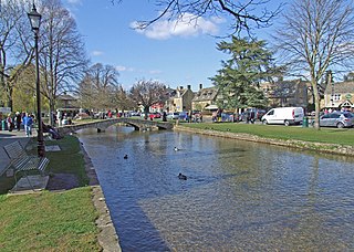
Bourton is a small village in Shropshire, England, 3 miles (5 km) southwest of Much Wenlock. It is part of the civil parish of Much Wenlock.

