
The Chesapeake & Delaware Canal is a 14-mile (22.5 km)-long, 450-foot (137.2 m)-wide and 35-foot (10.7 m)-deep ship canal that connects the Delaware River with the Chesapeake Bay in the states of Delaware and Maryland in the United States.

U.S. Route 301 (US 301) is a spur of U.S. Route 1 running through the South Atlantic States. It currently runs 1,099 miles (1,769 km) from Biddles Corner, Delaware at Delaware Route 1 to Sarasota, Florida at U.S. Route 41. It passes through the states of Delaware, Maryland, Virginia, North Carolina, South Carolina, Georgia, and Florida. It goes through the cities of Middletown, Delaware; Annapolis, Maryland; Richmond and Petersburg, Virginia; Rocky Mount, Wilson, and Fayetteville, North Carolina; Florence, South Carolina; Statesboro and Jesup, Georgia; and Ocala, Zephyrhills, and Sarasota, Florida.
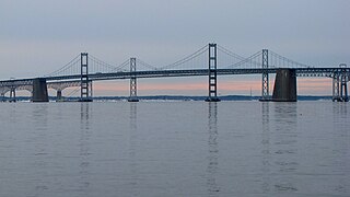
The Chesapeake Bay Bridge is a major dual-span bridge in the U.S. state of Maryland. Spanning the Chesapeake Bay, it connects the state's rural Eastern Shore region with the urban Western Shore, between Stevensville and the capital city of Annapolis. The original span, opened in 1952 and with a length of 4.3 miles (6.9 km), was the world's longest continuous over-water steel structure. The parallel span was added in 1973. The bridge is officially named the Gov. William Preston Lane Jr. Memorial Bridge after William Preston Lane Jr. who, as the 52nd Governor of Maryland, initiated its construction in the late 1940s finally after decades of political indecision and public controversy.
Maryland Route 213 (MD 213) is a 68.25-mile (109.84 km) state highway located on the Eastern Shore of Maryland in the United States. The route runs from MD 662 in Wye Mills, Queen Anne's County north to the Pennsylvania border in Cecil County, where the road continues into that state as Pennsylvania Route 841 (PA 841). The route, which is a two-lane undivided highway most of its length, passes through mostly rural areas as well as the towns of Centreville, Chestertown, Galena, Cecilton, Chesapeake City, and Elkton. MD 213 intersects many routes including U.S. Route 50 (US 50) near Wye Mills, US 301 near Centreville, and US 40 in Elkton. It crosses over the Chesapeake & Delaware Canal in Chesapeake City on the Chesapeake City Bridge. MD 213 is designated by the state as the Chesapeake Country Scenic Byway between the southern terminus and Chesapeake City with the portion north of MD 18 in Centreville a National Scenic Byway. In addition, the route is also considered part of the Atlantic to Appalachians Scenic Byway between Chesapeake City and MD 273 in Fair Hill.
Delaware Route 1 (DE 1) is a 102.63-mile-long (165.17 km) state highway in the U.S. state of Delaware. The route runs from the Maryland state line in Fenwick Island, Sussex County, where the road continues south into that state as Maryland Route 528 (MD 528), north to an interchange with Interstate 95 (I-95) in Christiana, New Castle County, where the road continues north as part of DE 7. Between Fenwick Island and Dover Air Force Base in Dover, Kent County, DE 1 is a four- to six-lane divided highway with at-grade intersections and occasional interchanges. The route heads north through the Delaware Beaches resort area along the Atlantic Ocean before it runs northwest through rural areas, turning north at Milford to continue to Dover. Upon reaching Dover, DE 1 becomes the Korean War Veterans Memorial Highway, a four- to six-lane freeway that is partially tolled. Between Dover and Tybouts Corner, DE 1 parallels U.S. Route 13 (US 13), crossing over and featuring interchanges with it multiple times. Past Tybouts Corner, the freeway heads north parallel to DE 7 to its terminus in Christiana. DE 1 serves as the main north-south state route in Delaware, connecting the Delaware Beaches with the Dover and Wilmington areas.
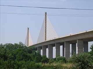
The Senator William V. Roth Jr. Bridge is a concrete and steel cable-stayed bridge that spans the Chesapeake & Delaware Canal near St. Georges, Delaware. The bridge is located near a tolled section of Delaware Route 1 that runs parallel to the St. Georges Bridge carrying U.S. Route 13. In November 2006, the bridge was named after U.S. Senator William V. Roth, Jr., who not only lent his name to the Roth IRA, but was instrumental in securing federal funding to build the bridge. It is owned and operated by the U.S. Army Corps of Engineers and does not carry a toll, despite the location of a nearby toll plaza.
U.S. Route 50 is a major east–west route of the U.S. Highway system, stretching just over 3,000 miles (4,800 km) from Ocean City, Maryland on the Atlantic Ocean to West Sacramento, California. In the U.S. state of Maryland, US 50 exists in two sections. The longer of these serves as a major route connecting Washington, D.C. with Ocean City; the latter is the eastern terminus of the highway. The other section passes through the southern end of Garrett County for less than 10 miles (16 km) as part of the Northwestern Turnpike, entering West Virginia at both ends. One notable section of US 50 is the dual-span Chesapeake Bay Bridge across the Chesapeake Bay, which links the Baltimore–Washington metropolitan area with the Eastern Shore region, allowing motorists to reach Ocean City and the Delaware Beaches.

Pennsylvania Route 32 is a scenic two-lane highway that runs along the west side of the Delaware River in Bucks County, Pennsylvania. It runs from U.S. Route 1 in Falls Township outside of Morrisville northwest to PA 611 in the village of Kintnersville in Nockamixon Township. PA 32 passes through Washington Crossing Historic Park, a Revolutionary War-themed historical park on the site of George Washington's crossing on the night of December 25–26, 1776. It also passes through the boroughs of Morrisville, Yardley, and New Hope.

The St. Georges Bridge is a steel tied arch bridge that carries U.S. Route 13 (US 13) across the Chesapeake & Delaware Canal in St. Georges, Delaware. Built by the U.S. Army Corps of Engineers and opened in 1942 as a high-level crossing, the bridge was the first four-lane, high-level crossing to span the canal. It replaced a previous vertical lift bridge which was damaged when a German merchant ship collided with it.

The Reedy Point Bridge carries Delaware Route 9 across the Chesapeake & Delaware Canal in Delaware City, Delaware, USA. A two-lane cantilever bridge similar in appearance to the Platt Bridge in Southwest Philadelphia, the Reedy Point Bridge was built by the U.S. Army Corps of Engineers and opened in 1968, replacing a lift bridge that crossed the C&D Canal prior to the 1955 widening project. Unlike the nearby St. Georges Bridge, the Reedy Point Bridge spans over salt marshes at the southern approach, the canal itself, and both Fort Dupont and the Governor Bacon Health Center. An obsolete double-leaf bascule drawbridge, located just less than ⅛ of a mile north of the northern abutment, allows Delaware Route 9 to cross over the Delaware Ship Channel and is technically part of the Reedy Point Bridge system. Both the high-level bridge and the drawbridge are maintained by the U.S. Army Corps of Engineers. In 2018, the old drawbridge was replaced with a fixed span.

The Chesapeake & Delaware Canal Lift Bridge is a railroad bridge with vertical-lift span in the U.S. state of Delaware. It carries a Delmarva Central Railroad rail line across the Chesapeake & Delaware Canal.
The Chesapeake City Bridge carries Maryland Route 213 across the Chesapeake & Delaware Canal in Chesapeake City, Maryland. There are two undivided traffic lanes and one sidewalk on the east side of the bridge. It was built in 1949 by the U.S. Army Corps of Engineers to provide a high-level canal crossing. An older vertical lift drawbridge was destroyed on July 28, 1942, after being struck by the tanker Franz Klasen. The bridge is identical in appearance to the old St. Georges Bridge in Delaware except for the number of lanes.

Delaware Route 896 (DE 896) is a state highway located in New Castle County, Delaware. The route runs from U.S. Route 13 (US 13) in Boyds Corner north to the Maryland border northwest of Newark, where the road becomes unsigned Maryland Route 896 (MD 896) briefly before heading into Pennsylvania as Pennsylvania Route 896 (PA 896). The route heads west from US 13 before turning north along with DE 71 in Mount Pleasant, crossing the Chesapeake & Delaware Canal on the Summit Bridge. After the bridge, DE 71 splits off to the east and the road continues to Glasgow, where it comes to an intersection with US 40. DE 896 continues north and interchange with Interstate 95 (I-95) before reaching Newark, where it bypasses the University of Delaware to the west by following DE 4, Elkton Road, and South Main Street. DE 896 comes to downtown Newark and continues northwest to the Maryland border. DE 896 has a business route, DE 896 Business, that passes through Glasgow, and had an alternate alignment south of Glasgow called DE 896 Alternate.
Interstate 895 (I-895) was a planned 6.4-mile-long (10.3 km) Interstate Highway in New Jersey and Pennsylvania that would have provided a freeway between I-295 near Burlington in Burlington County, New Jersey and I-95 near Bristol in Bucks County, Pennsylvania.
U.S. Route 301 (US 301) in the state of Maryland is a major highway that runs from Delaware to the Governor Harry W. Nice Memorial Bridge over the Potomac River into Virginia. It passes through three of Maryland's four main regions: the Eastern Shore, the Baltimore-Washington Metropolitan Area, and Southern Maryland. US 301 serves mainly as a bypass of Baltimore and Washington from Delaware to Virginia.
U.S. Route 301 (US 301) is a US Highway running from Sarasota, Florida north to Biddles Corner, Delaware. In the state of Delaware, the route runs 11.9 mi (19.2 km) across New Castle County from the Maryland state line southwest of Middletown northeast to its northern terminus at Delaware Route 1 (DE 1) in Biddles Corner, just south of the Senator William V. Roth Jr. Bridge that carries DE 1 over the Chesapeake & Delaware Canal in St. Georges. US 301 in Delaware is a four-lane freeway that is tolled. The toll road has interchanges with DE 299 west of Middletown, DE 71 north of Middletown, and Jamison Corner Road. The freeway uses all-electronic tolling, with tolls paid by E-ZPass or toll-by-plate. A mainline toll gantry is located north of the Maryland state line while there are ramp tolls on the southbound exits and northbound entrances at the three interchanges.

Delaware Route 15 (DE 15) is a state highway in the U.S. state of Delaware. The route runs from DE 14 west of Milford in Kent County to DE 71/DE 896 in Summit Bridge, New Castle County, just south of the Summit Bridge over the Chesapeake & Delaware Canal. DE 15 winds a path through many rural sections of Delaware, turning along many different roads. Most of the route, with the exception of the southern part of the route from Milford to Canterbury, runs to the west of U.S. Route 13 (US 13). DE 15 serves several cities and towns, including Wyoming, Dover, Clayton, and Middletown. The route intersects DE 12 near Felton, US 13 in Canterbury, DE 10 near Camden, DE 8 in Dover, DE 42 in Seven Hickories, DE 300 and DE 6 in the Clayton area, DE 299 in Middletown, and DE 286 near Summit Bridge.

Delaware Route 71 (DE 71) is a state highway in New Castle County, Delaware. The route runs from U.S. Route 13 (US 13) south of Townsend north to another intersection with US 13 in Tybouts Corner, traveling to the west of US 13 by way of Townsend, Middletown, and the Summit Bridge. The route overlaps DE 896 from Mount Pleasant to just north of the Summit Bridge, where DE 896 continues north to Glasgow.
U.S. Route 40 (US 40) is a US highway running from Silver Summit, Utah east to Atlantic City, New Jersey. In the US state of Delaware, it serves as a major east–west highway in northern New Castle County, just south of Wilmington. It runs from the Maryland state line west of Glasgow east to the Delaware Memorial Bridge over the Delaware River to New Jersey, at which point it is concurrent with Interstate 295 (I-295). Along the way, US 40 passes through suburban areas in Glasgow and Bear before running concurrent with US 13 and I-295 around New Castle. US 40 is a multilane divided highway the entire length across Delaware, with the section concurrent with I-295 a freeway.

U.S. Route 13 (US 13) is a U.S. highway running from Fayetteville, North Carolina north to Morrisville, Pennsylvania. In the U.S. state of Delaware, the route runs for 103.33 mi (166.29 km). It traverses the entire north–south length of the state from the Maryland state line in Delmar, Sussex County north to the Pennsylvania state line in Claymont, New Castle County. US 13 connects many important cities and towns in Delaware, including Seaford, Dover, and Wilmington. The entire length of US 13 in Delaware is a multilane divided highway with the exceptions of the segment through Wilmington and parts of Philadelphia Pike in Claymont. Between the Maryland state line and Dover, US 13 serves as one of the main north–south routes across the Delmarva Peninsula. From Dover north to Tybouts Corner, the route is followed by the controlled-access Delaware Route 1 (DE 1) toll road, which crosses the route several times and has multiple interchanges with it. US 13 bypasses downtown Wilmington to the east before it heads northeast of the city parallel to Interstate 495 (I-495) and the Delaware River to Claymont. US 13 is the longest numbered highway in the state of Delaware.

