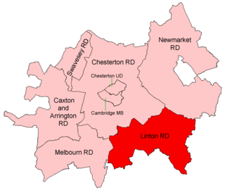
Coordinates: 52°18′07″N0°00′18″E / 52.302°N 0.005°E Swavesey was a rural district in Cambridgeshire, England, from 1894 to 1934.

A geographic coordinate system is a coordinate system that enables every location on Earth to be specified by a set of numbers, letters or symbols. The coordinates are often chosen such that one of the numbers represents a vertical position and two or three of the numbers represent a horizontal position; alternatively, a geographic position may be expressed in a combined three-dimensional Cartesian vector. A common choice of coordinates is latitude, longitude and elevation. To specify a location on a plane requires a map projection.
Rural districts were a type of local government area – now superseded – established at the end of the 19th century in England, Wales, and Ireland for the administration of predominantly rural areas at a level lower than that of the administrative counties.

Cambridgeshire is a county in the East of England, bordering Lincolnshire to the north, Norfolk to the north-east, Suffolk to the east, Essex and Hertfordshire to the south, and Bedfordshire and Northamptonshire to the west. The city of Cambridge is the county town. Modern Cambridgeshire was formed in 1974 as an amalgamation of the counties of Cambridgeshire and Isle of Ely and Huntingdon and Peterborough, the former covering the historic county of Cambridgeshire and the latter covering the historic county of Huntingdonshire and the Soke of Peterborough, historically part of Northamptonshire. It contains most of the region known as Silicon Fen.
It was formed under the Local Government Act 1894 from the part of the St Ives rural sanitary district which was in Cambridgeshire (the rest being in Huntingdonshire).

The Local Government Act 1894 was an Act of the Parliament of the United Kingdom that reformed local government in England and Wales outside the County of London. The Act followed the reforms carried out at county level under the Local Government Act 1888. The 1894 legislation introduced elected councils at district and parish level.

St Ives is a market town and civil parish in Cambridgeshire, England, 5 miles (8 km) east of Huntingdon and 12 miles (19 km) north-west of Cambridge. Historically in Huntingdonshire, St Ives is in the non-metropolitan district of the same name which covers a similar area to the historic county.
Huntingdonshire is a non-metropolitan district of Cambridgeshire, as well as a historic county of England. Its council is based in Huntingdon. Other towns in the district are St Ives, Godmanchester, St Neots and Ramsey. The population was 169,508 at the 2011 Census. Henry II, on his accession in 1154, declared all of Huntingdonshire a royal forest, but its favourable arable soil, with loam, light clay and gravel, hence good drainage, meant it was largely farmland by the 18th century.
It covered the civil parishes of

Boxworth is a village in South Cambridgeshire, situated about eight miles to the north-west of Cambridge. It falls under the Bar Hill ward and lies within the diocese of Ely. The village covers an area of 1,053 ha. Boxworth is a relatively small village, with around 100 houses.
Conington is a small village in the South Cambridgeshire district of Cambridgeshire with about 50 houses and 150 residents. The population of the village is included in the civil parish of Elsworth. It lies about five miles (8 km) southeast of Huntingdon and one mile south of the A14 road. The church is dedicated to St. Mary. It has a wonky steeple and houses one of the oldest bells in Cambridgeshire. There are some pictures and a description of the church at the Cambridgeshire Churches website. The village has two ponds; one is next to the church and the other is near the Manor House. The pond near the church used to be used as a splash pond for washing cart wheels. The pond near the Manor House used to supply water for Conington Hall. The pond is notoriously deep, and claimed the lives of two young boys in the Victorian era, when they attempted to learn to swim across it using a rope. The rope snapped, and the boys drowned. Today the pond is known by locals as big tree corner.

Fen Drayton is a small village between Cambridge and St. Ives in Cambridgeshire, England, and between the villages of Fenstanton and Swavesey.
It was merged in 1934 under a County Review Order into the Chesterton Rural District. It now forms part of the South Cambridgeshire district.
The Local Government Act 1929 was an Act of the Parliament of the United Kingdom that made changes to the Poor Law and local government in England and Wales.

Chesterton was a rural district in Cambridgeshire, England from 1894 to 1974.

South Cambridgeshire is a mostly rural local government district of Cambridgeshire, England with a population of 148,755 at the 2011 Census. It was formed on 1 April 1974 by the merger of Chesterton Rural District and South Cambridgeshire Rural District. It completely surrounds the city of Cambridge, which is administered separately from the district by Cambridge City Council.