Before the coming of the railway to the North Wales coast, the road through Sychnant Pass was the route of choice for mail coaches at high tide, when the faster and safer route along the sands was unusable. After leaving Conwy, the route runs westward through the valley on the south side of Mynydd y Dref (Conwy Mountain), which is topped by the hillfort of Castell Caer Seion. There are parallel tracks and footpaths (including the North Wales Path) on Mynydd y Dref for most of the way.
Also Allt-Wen (837ft, 255m) and Penmaenbach (804ft, 245m) can be climbed from here.
At the western end of the valley, the Sychnant Pass Road runs between the stone walls of the Pensychnant estate and through a narrow gap in the surrounding hills before descending steeply to the valley floor at Capelulo, reputedly the site of an early medieval chapel of Saint Ulo. Here there are two inns, a restaurant and a bistro, and in the ravine behind the inns is Nant Ddaear-y-llwynog (the Fairy Glen), a Victorian nature trail. From Capelulo it is an easy walk or short drive to the coast at Penmaenmawr.
Snowdonia, or Eryri, is a mountainous region and national park in North Wales. It contains all 15 mountains in Wales over 3000 feet high, including the country's highest, Snowdon, which is 1,085 metres (3,560 ft) tall. These peaks are all part of the Snowdon, Glyderau, and Carneddau ranges in the north of the region. The shorter Moelwynion and Moel Hebog ranges lie immediately to the south.
The A55, also known as the North Wales Expressway, is a major road in Wales and England, connecting Cheshire and North Wales. The vast majority of its length from Chester to Holyhead is a dual carriageway primary route, with the exception of the Britannia Bridge over the Menai Strait and several short sections where there are gaps in between the two carriageways. All junctions are grade separated apart from a roundabout east of Penmaenmawr and another nearby in Llanfairfechan. Initially, the road ran from Chester to Bangor. In 2001, it was extended across Anglesey to the ferry port of Holyhead parallel to the A5. The road improvements have been part funded with European money, under the Trans-European Networks programme, as the route is designated part of Euroroute E22.
Penmaenmawr is a town and community in Conwy County Borough, Wales, which was formerly in the parish of Dwygyfylchi and the traditional county of Caernarfonshire. It is on the North Wales coast between Conwy and Llanfairfechan and was an important quarrying town, though quarrying is no longer a major employer. The population of the community was 4,353 in 2011, including Dwygyfylchi and Capelulo. The town itself having a population of 2,868 (2011).
Conwy, previously known in English as Conway, is a walled market town, community and the administrative centre of Conwy County Borough in North Wales. The walled town and castle stand on the west bank of the River Conwy, facing Deganwy on the east bank. The town formerly lay in Gwynedd and prior to that in Caernarfonshire. The community, which also includes Deganwy and Llandudno Junction, had a population of 14,753 at the 2011 census.
The Crimea Pass is a mountain pass in North Wales, on the A470 road between Blaenau Ffestiniog and Dolwyddelan connecting the counties of Gwynedd and Conwy.
The Nantlle Valley is an area in Gwynedd, North Wales, characterised by its numerous small settlements.
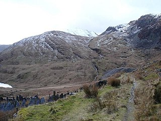
Foel-fras is a mountain in the Carneddau range, about 10 km east of Bethesda in North Wales. It lies on the border between the counties of Gwynedd and Conwy. With a summit elevation of 944 metres, it is officially the eleventh-highest summit in Wales. Foel-fras is located at the northern end of the main ridge of the Carneddau, between Drum to the north and Foel Grach to the south with the subsidiary summit of Garnedd Uchaf between it and Foel Grach. Due south and 400 m below lies the reservoir of Llyn Dulyn, while the smaller reservoir of Llyn Anafon lies to the north.
Llyn Geirionydd lies in a valley in North Wales where the northern edge of the Gwydyr Forest meets the lower slopes of the Carneddau mountains. The lake is almost a mile long and covers an area of 45 acres (180,000 m2), but is never any deeper than 50 ft (15 m) according to Jehu's survey. The lake can be reached by car from Trefriw or Llanrwst in the Conwy valley, the lane passing through the hamlet of Llanrhychwyn, or from the road through the Gwydir Forest. Access is not particularly easy by either route, but this has not stopped the lake being the only one designated in Snowdonia to permit power boats and water skiing. Many visitors also walk to the lake from the village of Trefriw or from the neighbouring lake of Llyn Crafnant, which runs parallel to it, but a mile distant, the two being separated by Mynydd Deulyn, “mountain of the two lakes”.
Sarn Helen refers to several stretches of Roman road in Wales. The 160-mile (260 km) route, which follows a meandering course through central Wales, connects Aberconwy in the north with Carmarthen in the west. Despite its length, academic debate continues as to the precise course of the Roman road. Many sections are now used by the modern road network while other parts are still traceable. However, there are sizeable stretches that have been lost and are unidentifiable.
The A4107 road is an A road in Neath Port Talbot County Borough, Wales. It begins in Port Talbot and heads up the Afan Valley in a north easterly direction. It then continues over the moors eastwards until it connects with the A4061 road south west of Treorchy in the Rhondda Valley.
Llangelynnin is a former parish in the Conwy valley, in Conwy county borough, north Wales. Today the name exists only in connection with the church, a school in the nearby village of Henryd, and the nearby mountain ridge, Craig Celynnin.
Tal y Fan is an outlying peak of the Carneddau mountains in North Wales. It is one of the four Marilyns that make up the Carneddau, the others being Carnedd Llywelyn, Pen Llithrig y Wrach and Creigiau Gleision.
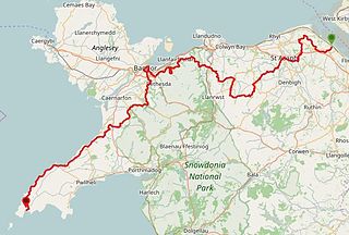
The North Wales Path is a long-distance walk of some 60 miles (97 km) that runs close to the coast of northern Wales between Prestatyn in the east and Bangor in the west. Parts of it overlap with the Wales Coast Path. The path runs along parts of the Clwydian Range and Dee Valley Area of Outstanding Natural Beauty (AONB). The path was devised, implemented and maintained by the then Countryside Council for Wales and the three councils of: Gwynedd, Conwy, and Denbighshire.
The Cedryn Quarry Tramway was an industrial narrow gauge railway that connected the slate quarries at Cedryn and Cwm Eigiau to the quays at Dolgarrog in the Conwy valley.
National Cycle Route 5 is a route of the United Kingdom National Cycle Network, running from Reading to Holyhead.
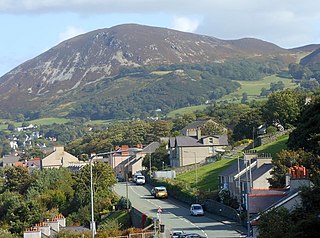
Mynydd y Dref, also known as Conwy Mountain, is a hilly area to the west of the town of Conwy, in North Wales. To the north it overlooks the sea of Conwy Bay, and to the south lie the foothills of the Carneddau range of mountains, of which it forms a part. Mynydd y Dref is the remains of an ancient volcano that erupted about 450 million years ago.
Dwygyfylchi is a village in Conwy County Borough, Wales. It is part of the community of Penmaenmawr which has a population of 4,353. The electoral ward of Capelulo which includes Dwygyfylchi had a population of 1,485 in 2011. It forms part of the historic county of Caernarfonshire.
The B4329 is a scenic route and a former turnpike in Pembrokeshire, West Wales. It links Eglwyswrw in the north of the county to Haverfordwest, the county town in the south, in an approximately southwesterly direction, crossing the Preseli Mountains. It links to the A487 trunk road at both its northern and southern ends.
The North Wales Pilgrim's Way is a long-distance walking route in North Wales, running from near Holywell in the east to Bardsey Island in the west. The first half of the trail takes an inland route, with the second half following the north coast of the Llŷn Peninsula. It measures 133.9 miles (215 km) in length, and was officially launched at Porth y Swnt, Aberdaron on 10 July 2014.
This page is based on this Wikipedia article Text is available under the CC BY-SA 4.0 license; additional terms may apply. Images, videos and audio are available under their respective licenses.