
Myanmar is divided into 21 administrative divisions, which include seven regions, seven states, one union territory, one self-administered division, and five self-administered zones.

Dawei is a city in south-eastern Myanmar and is the capital of the Tanintharyi Region, formerly known as the Tenasserim Division, on the eastern bank of the Dawei River. The city is about 614.3 km (381.7 mi) southeast of Yangon. Its population is 146,964. Dawei is a port at the head of the Dawei River estuary, 30 km (18.6 mi). from the Andaman Sea. As a result, the city is prone to flooding during the monsoon season. Dawei People is also the name of one of Myanmar's 135 ethnic minorities.

The Mergui Archipelago is located in far southern Myanmar (Burma) and is part of the Tanintharyi Region. It consists of more than 800 islands, varying in size from very small to hundreds of square kilometres, all lying in the Andaman Sea off the western shore of the Malay Peninsula near its landward (northern) end where it joins the rest of Indochina. They are occasionally referred to as the Pashu Islands because the Malay inhabitants are locally called Pashu.

Myeik is a rural city in Tanintharyi Region, Myanmar, located in the extreme south of the country on the coast off an island on the Andaman Sea. As of 2010, the estimated population was over 209,000. Myeik is the largest city in Tanintharyi Region, and serves as the regional headquarters of Myanmar Navy's Tanintharyi Regional Command. The area inland from the city is a major smuggling corridor into Thailand. The Singkhon Pass, also known as the Maw-daung Pass, has an international cross-border checkpoint.
Tanintharyi or Taninthayi is a small town in Tanintharyi Township, Myeik District, in the Tanintharyi Region of south-western Myanmar. It is the administrative seat for the township. The town is located on the Great Tenasserim River which eventually enters the sea at Myeik. The town is located at the confluence of this river and a tributary known as the "Little Tenasserim River" which runs south.

Kawkareik, also spelled as Kawkarike, is a town in Karen State, Myanmar. It is the capital of Kawkaraik District and Kawkaraik Township.

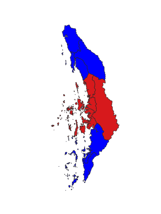
Tanintharyi Region is a region of Myanmar, covering the long narrow southern part of the country on the northern Malay Peninsula, reaching to the Kra Isthmus. It borders the Andaman Sea to the west and the Tenasserim Hills, beyond which lie Thailand, to the east. To the north is the Mon State. There are many islands off the coast, the large Mergui Archipelago in the southern and central coastal areas and the smaller Moscos Islands off the northern shores. The capital of the division is Dawei (Tavoy). Other important cities include Myeik (Mergui) and Kawthaung. The division covers an area of 43,344.9 square kilometres (16,735.6 sq mi), and had a population of 1,406,434 at the 2014 Census.

Taninthayi Township is a township of Myeik District in the Taninthayi Division of Myanmar. The principal town is Taninthayi.

Palaw Township is a township of Myeik District in the Taninthayi Region of Burma (Myanmar). The principal town and administrative seat is Palaw. The township has two other towns - Palauk and Pala.
Myeik District is a district in the Tanintharyi Region of Burma (Myanmar). The district covers an area of 18,121 km2, and had a population of 693,087 at the 2014 Census.
The Tenasserim Hills or Tenasserim Range is the geographical name of a roughly 1,700 km long mountain chain, part of the Indo-Malayan mountain system in Southeast Asia.
The Great Tenasserim River or the Tanintharyi River is a major river of southeastern Burma. It flows through the Tanintharyi Region, past the town of Tanintharyi, and enters the sea at Myeik (Mergui). The river rises from the Tenasserim Range at an altitude of 2,074 m (6,804 ft), and flows into the Andaman Sea. The region formed by this river is also known as Tenasserim, or Tanintharyi in Burmese. It is in a constricted coastal region in southeastern Myanmar, which borders Thailand on the east and the Andaman Sea on the west.
The Myeik dialect, also known as Beik in Burmese, Mergui and Merguiese in English, and Marit (มะริด) in Thai, is a divergent dialect of Burmese, spoken in Myeik, the second largest town in Tanintharyi Region, the southernmost region of Myanmar. Beik shares many commonalities with the Tavoyan dialect, although there are substantial differences especially with regard to phonology.

Singkhon Pass, also referred to as Sing Khon and as Maw Daung after the name of the Burmese town west of the border, is a pass across the Tenasserim Hills on the border between Thailand and Myanmar, at an elevation of 245 metres (804 ft). The pass is close to the narrowest point of Thailand in Khlong Wan (คลองวาฬ) subdistrict, Mueang Prachuap Khiri Khan District, Prachuap Khiri Khan Province.
Sinbyudaing, is a small village of Dawei District in the Taninthayi Region of Myanmar. It is located on the western side of the Tenasserim Range near the border with Thailand.

Lei Lei Maw is a Burmese politician and a medical doctor who served as Chief Minister of Tanintharyi Region and Taninthayi Region Parliament MP for Thayetchaung Township Constituency No. 1. She was removed from her chief minister position for corruption on 11 March 2019. She is one of only two women chief ministers appointed by President Htin Kyaw. People called her Jayalalitha of Myanmar.

The Tavoy campaign of 1788 was a conflict between the Kingdom of Burma under Konbaung dynasty and the Kingdom of Siam under the Chakri dynasty over the town of Tavoy and the Tenasserim Coast.