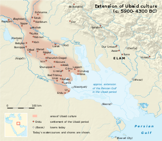
The Ubaid period is a prehistoric period of Mesopotamia. The name derives from Tell al-'Ubaid where the earliest large excavation of Ubaid period material was conducted initially by Henry Hall and later by Leonard Woolley.

Urkesh or Urkish is a tell, or settlement mound, located in the foothills of the Taurus Mountains in Al-Hasakah Governorate, northeastern Syria. It was founded during the fourth millennium BC possibly by the Hurrians on a site which appears to have been inhabited previously for a few centuries.

The Tabqa Dam, or al-Thawra Dam as it is also named, most commonly known as Euphrates Dam, is an earthen dam on the Euphrates, located 40 kilometres (25 mi) upstream from the city of Raqqa in Raqqa Governorate, Syria. The city of Al-Thawrah is located immediately south of the dam. The dam is 60 metres (200 ft) high and 4.5 kilometres (2.8 mi) long and is the largest dam in Syria. Its construction led to the creation of Lake Assad, Syria's largest water reservoir. The dam was constructed between 1968 and 1973 with help from the Soviet Union. At the same time, an international effort was made to excavate and document as many archaeological remains as possible in the area of the future lake before they would be flooded by the rising water. When the flow of the Euphrates was reduced in 1974 to fill the lake behind the dam, a dispute broke out between Syria and Iraq that was settled by intervention from Saudi Arabia and the Soviet Union. The dam was originally built to generate hydroelectric power, as well as irrigate lands on both sides of the Euphrates. The dam has not reached its full potential in either of these objectives.

Tell Leilan is an archaeological site situated near the Wadi Jarrah in the Khabur River basin in Al-Hasakah Governorate, northeastern Syria, a region formerly a part of ancient Assyria. The site has been occupied since the 5th millennium BC. During the late third millennium, the site was known as Shekhna. During that time it was under control of the Akkadian Empire. Around 1800 BC, the site was renamed "Shubat-Enlil" by the Assyrian king, Shamshi-Adad I and it became the capital of Assyria in northern Mesopotamia. Shubat-Enlil was abandoned around 1700 BC.
Tell Brak was an ancient city in Syria; its remains constitute a tell located in the Upper Khabur region, near the modern village of Tell Brak, 50 kilometers north-east of Al-Hasaka city, Al-Hasakah Governorate. The city's original name is unknown. During the second half of the third millennium BC, the city was known as Nagar and later on, Nawar.

Chagar Bazar is a tell, or settlement mound, in northern Syria.

Jemdet Nasr is a tell or settlement mound in Babil Governorate (Iraq) that is best known as the eponymous type site for the Jemdet Nasr period. The site was first excavated in 1926 by Stephen Langdon, who found proto-cuneiform clay tablets in a large mudbrick building thought to be the ancient administrative centre of the site. A second season took place in 1928, but this season was very poorly recorded. Subsequent excavations in the 1980s under British archaeologist Roger Matthews were, among other things, undertaken to relocate the building excavated by Langdon. These excavations have shown that the site was also occupied during the Ubaid, Uruk and Early Dynastic I periods.

Tepe Gawra is an ancient Mesopotamian settlement in the Mosul region of northwest Iraq that was occupied between 5000 and 1500 BC. It contains remains from the Halaf period, the Ubaid period, and the Uruk period. Tepe Gawra contains material relating to the Halaf-Ubaid Transitional period c. 5,500–5,000 BC.

The Halaf culture is a prehistoric period which lasted between about 6100 BC and 5100 BC. The period is a continuous development out of the earlier Pottery Neolithic and is located primarily in south-eastern Turkey, Syria, and northern Iraq, although Halaf-influenced material is found throughout Greater Mesopotamia.
Tell Arpachiyah is a prehistoric archaeological site in Nineveh Province (Iraq). It takes its name from a more recent village located about 4 miles (6.4 km) from Nineveh. The proper name of the mound on which the site is located is Tepe Reshwa.
Tell es-Sawwan is an important Samarran period archaeological site in Saladin Province, Iraq. It is located 110 kilometres (68 mi) north of Baghdad, and south of Samarra.

The Hassuna culture is a Neolithic archaeological culture in northern Mesopotamia dating to the early sixth millennium BC. It is named after the type site of Tell Hassuna in Iraq. Other sites where Hassuna material has been found include Tell Shemshara.

The Qal'at al-Bahrain, also known as the Bahrain Fort or Portuguese Fort, is an archaeological site located in Bahrain, on the Arabian Peninsula. Archaeological excavations carried out since 1954 have unearthed antiquities from an artificial mound of 12 m (39 ft) height containing seven stratified layers, created by various occupants from 2300 BC up to the 18th century, including Kassites, Greeks, Portuguese and Persians. It was once the capital of the Dilmun civilization and was inscribed as a UNESCO World Heritage Site in 2005.
Tell Shemshara is an archaeological site located along the Little Zab in Sulaymaniyah Governorate, northeastern Iraq. The site was excavated between 1957 and 1959 by Danish and Iraqi archaeologists and was inundated by Lake Dukan until recently. The excavations showed that the site was occupied, although not continuously, from the Hassuna period until the 14th century CE. A small archive recovered from the Middle Bronze Age layers revealed that, at least in that period, the site was called Shusharra and was the capital of a small, semi-independent polity called māt Utêm or "land of the gatekeeper" ruled by a man called Kuwari.
Tell Halula is a large, prehistoric, neolithic tell, about 8 hectares (860,000 sq ft) in size, located around 105 kilometres (65 mi) east of Aleppo and 25 kilometres (16 mi) northwest of Membij in the Raqqa Governorate of Syria.
The Halaf-Ubaid Transitional period is a prehistoric period of Mesopotamia. It lies chronologically between the Halaf period and the Ubaid period. It is still a complex and rather poorly understood period. At the same time, recent efforts were made to study the gradual change from Halaf style pottery to Ubaid style pottery in various parts of North Mesopotamia.

Tell al-'Ubaid is a low, relatively small tell west of nearby Ur in southern Iraq's Dhi Qar Governorate. The majority of the remains are from the Chalcolithic Ubaid period, for which Tell al-'Ubaid is the type site, with an Early Dynastic temple and cemetery at the highest point.
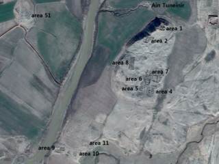
Tell Tuneinir is an archaeological site in northeastern Syria. It dates to the early third millennium BC and shows signs of continuous habitation lasting until the beginning of the 15th century AD with epochs during the Byzantine empire, when it was known as the city of Thannuris (Thannourios), and during the Ayyubid period.


