A Site of Special Scientific Interest (SSSI) in Great Britain or an Area of Special Scientific Interest (ASSI) in the Isle of Man and Northern Ireland is a conservation designation denoting a protected area in the United Kingdom and Isle of Man. SSSI/ASSIs are the basic building block of site-based nature conservation legislation and most other legal nature/geological conservation designations in the United Kingdom are based upon them, including national nature reserves, Ramsar sites, Special Protection Areas, and Special Areas of Conservation. The acronym "SSSI" is often pronounced "triple-S I".

The River Mersey is a river in the North West of England. Its name is derived from Old English and means "boundary river", possibly referring to its having been a border between the ancient kingdoms of Mercia and Northumbria. For centuries it has formed part of the boundary between the historic counties of Lancashire and Cheshire.

The River Dee is a river in the United Kingdom. It flows through parts of both Wales and England, forming part of the border between the two countries.

Heswall is a town on the Wirral, Merseyside, England. At the 2001 Census, the population was 16,012, including the nearby villages of Barnston and Gayton.

The North Wirral Coastal Park, on the Wirral Peninsula, England is a coastal park including public open space, common land, natural foreshore and sand-dunes. The park lies between Dove Point in Meols, and the Kings Parade in New Brighton, and was created in 1986.

Blackmoor Copse is a woodland in southeast Wiltshire, England, managed as a nature reserve by the Wiltshire Wildlife Trust. The copse lies within Pitton and Farley parish, about 5+1⁄2 miles (9 km) east of Salisbury.

Thurstaston Common is an area of almost 250 acres (100 ha) of parklands, wood and heath between Frankby and Thurstaston, on the Wirral Peninsula in North West England. The common is jointly owned by the National Trust and the Metropolitan Borough of Wirral. Royden Country Park is nearby and offers additional facilities.

The Dee Estuary is a large estuary by means of which the River Dee flows into Liverpool Bay. The estuary starts near Shotton after a five-mile (8 km) 'canalised' section and the river soon swells to be several miles wide forming the boundary between the Wirral Peninsula in north-west England and Flintshire in north-east Wales. The Dee Estuary's largest towns along it include Hollywell, Flint, Connah's Quay, Shotton, Queensferry, Saltney Ferry, Chester (City), Heswall, West Kirby and Neston as well as other villages and towns alongside it. The A548 also passes along the estuary in Wales and parts of Cheshire West and Chester and Merseyside in England. The North Wales Coast Line follows the course of the Dee Estuary between Prestatyn and Chester.

Brotherton Park and Dibbinsdale Local Nature Reserve informally known as Dibbinsdale is a combined park and local nature reserve managed by the Metropolitan Borough of Wirral and located in Bromborough, Merseyside, England.

Thurstaston is a village on the Wirral Peninsula, Merseyside, England. It is part of the West Kirby and Thurstaston Ward of the Metropolitan Borough of Wirral and the parliamentary constituency of Wirral West. The village lies on the A540 road between Heswall and Caldy, although it extends some distance down Station Road to the Wirral Way and the River Dee estuary.
Seaton Dunes and Common is a 312.1 hectare biological Site of Special Scientific Interest in Hartlepool, County Durham, England notified in 1966. Part of it is a Local Nature Reserve.

Red Rocks (SSSI) is an area of sand dunes and reed beds at the mouth of the Dee Estuary and to the west of Hoylake on the Wirral Peninsula, England.

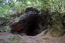
Dee Cliffs (SSSI) is an area of cliffs on the eastern side of the Dee Estuary and to the west of Thurstaston on the Wirral Peninsula, England.
Cleaver Heath Nature Reserve is a nature reserve in Heswall, on the Wirral Peninsula, managed by the Cheshire Wildlife Trust. It forms part of the Heswall Dales Site of Special Scientific Interest (SSSI).

Bourton Down is an 11.17-hectare (27.6-acre) biological Site of Special Scientific Interest near Bourton-on-the-Hill in Gloucestershire, notified in 1974. The site is listed in the 'Cotswold District' Local Plan 2001-2011 as a Key Wildlife Site (KWS).

Boxwell SSSI is a 5.31-hectare (13.1-acre) biological Site of Special Scientific Interest in Gloucestershire, notified in 1954. The site is listed in the 'Cotswold District' Local Plan 2001-2011 as a Key Wildlife Site (KWS).