Footnotes and references
Related Research Articles

The Oregon Trail was a 2,170-mile (3,490 km) east–west, large-wheeled wagon route and emigrant trail in the United States that connected the Missouri River to valleys in Oregon Territory. The eastern part of the Oregon Trail spanned part of what is now the state of Kansas and nearly all of what are now the states of Nebraska and Wyoming. The western half of the trail spanned most of the current states of Idaho and Oregon.

Fort Bridger was originally a 19th-century fur trading outpost established in 1842, on Blacks Fork of the Green River, in what is now Uinta County, Wyoming, United States. It became a vital resupply point for wagon trains on the Oregon Trail, California Trail, and Mormon Trail. The Army established a military post here in 1858 during the Utah War, until it was finally closed in 1890. A small town, Fort Bridger, Wyoming, remains near the fort and takes its name from it.

A mountain man is an explorer who lives in the wilderness and makes his living from hunting and trapping. Mountain men were most common in the North American Rocky Mountains from about 1810 through to the 1880s. They were instrumental in opening up the various emigrant trails allowing Americans in the east to settle the new territories of the far west by organized wagon trains traveling over roads explored and in many cases, physically improved by the mountain men and the big fur companies originally to serve the mule train-based inland fur trade.

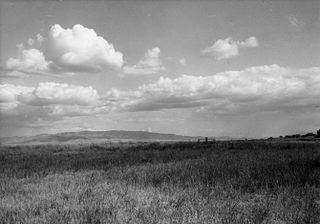
South Pass is a route across the Continental Divide, in the Rocky Mountains in southwestern Wyoming. It lies in a broad high region, 35 miles (56 km) wide, between the nearly 14,000 ft (4,300 m) Wind River Range to the north and the over 8,500 ft (2,600 m) Oregon Buttes and arid, saline near-impassable Great Divide Basin to the south. The Pass lies in southwestern Fremont County, approximately 35 miles (56 km) SSW of Lander.

The Mormon Trail is the 1,300-mile (2,100 km) long route from Illinois to Utah on which Mormon pioneers traveled from 1846–47. Today, the Mormon Trail is a part of the United States National Trails System, known as the Mormon Pioneer National Historic Trail.
Fort Hall was a fort in the Western United States that was built in 1834 as a fur trading post by Nathaniel Jarvis Wyeth. It was located on the Snake River in the eastern Oregon Country, now part of present-day Bannock County in southeastern Idaho. Wyeth was an inventor and businessman from Boston, Massachusetts, who also founded a post at Fort William, in present-day Portland, Oregon, as part of a plan for a new trading and fisheries company. In 1837, unable to compete with the powerful British Hudson's Bay Company, based at Fort Vancouver, Wyeth sold both posts to it. Great Britain and the United States both operated in the Oregon Country in these years.

The California Trail was an emigrant trail of about 1,600 mi (2,600 km) across the western half of the North American continent from Missouri River towns to what is now the state of California. After it was established, the first half of the California Trail followed the same corridor of networked river valley trails as the Oregon Trail and the Mormon Trail, namely the valleys of the Platte, North Platte, and Sweetwater rivers to Wyoming. The trail has several splits and cutoffs for alternative routes around major landforms and to different destinations, with a combined length of over 5,000 mi (8,000 km).

The Mormon pioneers were members of the Church of Jesus Christ of Latter-day Saints, also known as Latter-day Saints, who migrated beginning in the mid-1840s until the late-1860s across the United States from the Midwest to the Salt Lake Valley in what is today the U.S. state of Utah. At the time of the planning of the exodus in 1846, the territory comprising present-day Utah was part of the Republic of Mexico, with which the U.S. soon went to war over a border dispute left unresolved after the annexation of Texas. The Salt Lake Valley became American territory as a result of the Treaty of Guadalupe Hidalgo, which ended the war.

William H. Clayton was a clerk, scribe, and friend to the religious leader Joseph Smith. Clayton, born in England, was also an American pioneer journalist, inventor, lyricist, and musician. He joined the Church of Jesus Christ of Latter Day Saints in 1837 and served as the second counselor to the British mission president Joseph Fielding while proselyting in Manchester. He led a group of British converts in emigrating to the United States in 1840 and eventually settled in Nauvoo, Illinois, where he befriended Joseph Smith and became his clerk and scribe. He was a member of the Council of Fifty and Smith's private prayer circle.

The Hastings Cutoff was an alternative route for westward emigrants to travel to California, as proposed by Lansford Hastings in The Emigrant's Guide to Oregon and California. The ill-fated Donner Party infamously took the route in 1846.
Meek Cutoff was a horse trail road that branched off the Oregon Trail in northeastern Oregon and was used as an alternate emigrant route to the Willamette Valley in the mid-19th century. The road was named for frontiersman Stephen Meek, who was hired to lead the first wagon train along it in 1845. The journey was a particularly hard one, and many of the pioneers lost their lives.
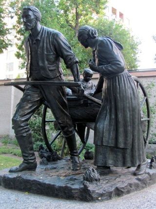
The Mormon handcart pioneers were participants in the migration of members of the Church of Jesus Christ of Latter-day Saints to Salt Lake City, Utah, who used handcarts to transport their belongings. The Mormon handcart movement began in 1856 and continued until 1860.
In 1841, the Bartleson–Bidwell Party, led by Captain John Bartleson and John Bidwell, became the first American emigrants to attempt a wagon crossing from Missouri to California.

The Emigrant Trail in Wyoming, which is the path followed by Western pioneers using the Oregon, California, and Mormon Trails, spans 400 miles (640 km) through the U.S. state of Wyoming. The trail entered from Nebraska on the eastern border of the state near the present day town of Torrington and exited on the western border near the towns of Cokeville and Afton. An estimated 350,000 to 400,000 settlers traveled on the trail through Wyoming between 1841 and 1868. All three trails follow the same path through most of the state. The Mormon Trail splits at Fort Bridger and enters Utah, while the Oregon and California Trails continue to Idaho.

The Great Platte River Road was a major overland travel corridor approximately following the course of the Platte River in present-day Nebraska and Wyoming that was shared by several popular emigrant trails during the 19th century, including the Trapper's Trail, the Oregon Trail, the Mormon Trail, the California Trail, the Pony Express route, and the military road connecting Fort Leavenworth and Fort Laramie. The road, which extended nearly 370 miles (600 km) from the Second Fort Kearny to Fort Laramie, was utilized primarily from 1841 to 1866. In modern times it is often regarded as a sort of superhighway of its era, and has been referred to as "the grand corridor of America's westward expansion".
Appleton Milo Harmon was an American farmer, businessman, and builder known as an early member of the Church of Jesus Christ of Latter-day Saints and a leading pioneer of the emigration to Salt Lake City and settlement of Utah Territory.
In the history of the American frontier, pioneers built overland trails throughout the 19th century, especially between 1829 and 1870, as an alternative to sea and railroad transport. These immigrants began to settle much of North America west of the Great Plains as part of the mass overland migrations of the mid-19th century. Settlers emigrating from the eastern United States did so with various motives, among them religious persecution and economic incentives, to move from their homes to destinations further west via routes such as the Oregon, California, and Mormon Trails. After the end of the Mexican–American War in 1849, vast new American conquests again encouraged mass immigration. Legislation like the Donation Land Claim Act and significant events like the California Gold Rush further encouraged settlers to travel overland to the west.

The historic 2,170-mile (3,490 km) Oregon Trail connected various towns along the Missouri River to Oregon's Willamette Valley. It was used during the 19th century by Great Plains pioneers who were seeking fertile land in the West and North.

The roadometer was a 19th-century device like an odometer for measuring mileage, mounted on a wagon wheel. One such device was invented in 1847 by William Clayton, Orson Pratt, and Appleton Harmon, pioneers of the Church of Jesus Christ of Latter-day Saints.

Thomas Dove Keizur was one of the earliest American pioneers to settle in the Oregon Country. In 1843, he led his large family from Missouri to Oregon over the Oregon Trail. He homesteaded in Oregon's Willamette Valley in an area north of modern-day Salem, Oregon. Keizur was one of eight citizens elected to serve on Oregon's third pre-provisional legislative committee which helped lay the foundation for the establishment of the Oregon Territory. He was also the first captain of the Oregon Rangers, the first militia unit organized in Oregon. Today, the city of Keizer, Oregon, is named in his honor.
References
- ↑ "Pacific Springs (on the Oregon Trail)" . Retrieved 2010-11-28.
- 1 2 3 Archived online by Brigham Young University. "Clayton's Emigrant Guide" . Retrieved 2010-11-28.
- 1 2 Kroll, Helen B. (June 1944). "The Books That Enlightened the Emigrants". Oregon Historical Quarterly. 45 (2): 103–123. JSTOR 20611541.
- 1 2 3 4 Allen, James B. (2002). No Toil Nor Labor Fear: The Story of William Clayton. Provo, UT: Brigham Young University Press. ISBN 0842525033.