The topic of this article may not meet Wikipedia's general notability guideline .(July 2021) |

The Lookoff in Nova Scotia
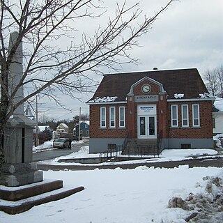
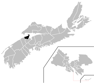
The Lookoff is a community in the Canadian province of Nova Scotia, located in Kings County.

The topic of this article may not meet Wikipedia's general notability guideline .(July 2021) |
The Lookoff is a community in the Canadian province of Nova Scotia, located in Kings County.

The Gulf of St. Lawrence is the outlet of the North American Great Lakes via the St. Lawrence River into the Atlantic Ocean. The gulf is a semi-enclosed sea, covering an area of about 226,000 square kilometres (87,000 sq mi) and containing about 34,500 cubic kilometres (8,300 cu mi) of water, at an average depth of 152 metres (500 ft).
Stewiacke is a town located in southern Colchester County, Nova Scotia, Canada. The town was incorporated on August 30, 1906.

Blomidon Provincial Park is a camping and day-use provincial park located at Cape Blomidon on the shores of the Minas Basin in Nova Scotia, Canada. It is known for its hiking and for views over the world's highest tides. Blomidon is located on 1,875 acres (7.6 km2) of land with 600 ft high cliffs. It is accessible via Nova Scotia Route 358.
Kings North is a provincial electoral district in Nova Scotia, Canada, that elects one member of the Nova Scotia House of Assembly.

Kings South is a provincial electoral district in Nova Scotia, Canada, that elects one member of the Nova Scotia House of Assembly. It includes the town of Wolfville, the village of New Minas, the community of Coldbrook, and Glooscap First Nation.
Route 358 is a collector road in the Canadian province of Nova Scotia.

Cumberland Basin is an inlet and northeasternmost part of the Bay of Fundy, located on the border between the Canadian provinces of Nova Scotia and New Brunswick.

Partridge Island is a significant historical, cultural and geological site located near the mouth of Parrsboro Harbour and the town of Parrsboro on the Minas Basin, in Cumberland County, Nova Scotia, Canada. It attracts many visitors including sightseers, swimmers, photographers, hikers and amateur geologists. Partridge Island is actually a peninsula that is connected to the mainland by a sandbar isthmus. According to local legend, the isthmus was created during the Saxby Gale of 1869. The hiking trail to the top of the island affords scenic views of key landforms on the Minas Basin including Cape Blomidon, Cape Split and Cape Sharp. The nearby Ottawa House By-the-Sea Museum contains artifacts and exhibits illustrating the history of the former village at Partridge Island, which dates from the 1770s. Partridge Island is a favourite hunting ground for rockhounds because its ancient sandstone and basalt cliffs are steadily eroded by the fast-moving currents of the world's highest tides. Rocks and debris worn away from its cliffs are dragged down the beach making it possible to find gemstones, exotic-looking zeolite minerals and fossils. Fossil hunters are warned, however, that although one or two loose specimens may be collected, Nova Scotia law requires that they be sent or taken to a museum for further study, and no fossils may be excavated from bedrock without a permit.
The River Hebert is a small tidal river that empties into the Cumberland Basin, and is contained completely within Cumberland County, Nova Scotia. According to estimates by the Province of Nova Scotia, there were 9,092 people resident within the Maccan/Kelley/Hebert watershed in 2011.

The Kennetcook River is a river that flows through Hants County, Nova Scotia. From headwaters near the mouth of the Shubenacadie River, the Kennetcook traverses about 45 kilometres of mostly rural terrain, discharging into the Avon River at Windsor. The Kennetcook cuts through fossiliferous limestone rocks for part of its length. A tidal river near its mouth, the Kennetcook experiences a tidal bore which may be seen at Scotch Village. It is a known salmon river popular with anglers.
The Maccan River is a small tidal river contained completely within Cumberland County, Nova Scotia. The river terminates at the confluence of River Hebert at Amherst Point, and empties into the Cumberland Basin. The river's tidal bore may be viewed from the Tidal Wetlands Park in Maccan. According to estimates by the Province of Nova Scotia, there are 9,092 people resident within the Maccan/Kelly/Hebert watershed in 2011.
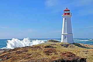
Louisbourg Lighthouse is an active Canadian lighthouse in Louisbourg, Nova Scotia. The current tower is the fourth in a series of lighthouses that have been built on the site, the earliest was the first lighthouse in Canada.
Spectacle Lake could mean the following :

South Maitland is a community in the Canadian province of Nova Scotia, located in the Municipal District of East Hants, Hants County, Nova Scotia. The community was one of the stops on the Shubenacadie Canal system and the site of a number of 19th century shipyards including the yard that built the barque Calburga in 1890, the last large square rigger to sail under a Canadian flag. The village is best known for the historic bridge built over the Shubenacadie River, a large bridge built over challenging tidal waters by the Midland Railway, part of the Dominion Atlantic Railway in 1901. Demolished in the 1990s, a surviving abutment of the railway bridge was retrofitted in 2006 by the Fundy Tidal Interpretive Centre at South Maitland as an interpretive lookoff and walking trail showcasing the massive tides of the Shubenacadie River. A former railway caboose is also preserved beside the interpretive tail.
Maccan is a small community in the Canadian province of Nova Scotia, located in Cumberland County 10 minutes away from Amherst, Nova Scotia on Route 302.
There are various Black Lakes in Nova Scotia, Canada. They vary widely in size, depth and usability. Many counties, such as Cumberland, Halifax, Inverness, and Pictou Counties have more than one Black Lake so named, while other counties mentioned in this article have only one named Black Lake.

Prescott House Museum is a historic house and gardens located in Starr's Point, Nova Scotia which is part of the Nova Scotia Museum. Built between 1812 and 1816 by Charles Ramage Prescott as the centrepiece of his country estate called Acacia Grove, it is one of the best preserved Georgian houses in Canada.

A township in Nova Scotia, Canada, was an early form of land division and local administration during British colonial settlement in the 18th century. They were created as a means of populating the colony with people loyal to British rule. They were typically rural or wilderness areas of around 100,000 acres (400 km2) that would eventually include several villages or towns. Some townships, but not all, returned a member to the General Assembly of Nova Scotia; others were represented by the members from the county. Townships became obsolete by 1879 by which time towns and counties had become incorporated.

The Louisbourg Lighthouse Trail is a hiking trail on Cape Breton Island in the Canadian province of Nova Scotia. The trailhead is located on Lighthouse Point, at the Louisbourg Lighthouse, within the Fortress of Louisbourg National Historic Site. The Louisbourg Lighthouse is the site of Canada’s first lighthouse which was built here in 1734.
Coordinates: 45°11′56″N64°25′7″W / 45.19889°N 64.41861°W
| | This Kings County, Nova Scotia location article is a stub. You can help Wikipedia by expanding it. |