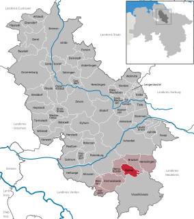
Bothel is a municipality in the district of Rotenburg, Germany in the Stade Geest region of central Lower Saxony. It has 2,500 inhabitants. Bothel was founded by workers of the nearby Trochel Forest. The name developed from Borstel which is Old Saxon and means "little woods".

Bassenthwaite is a village and civil parish in the borough of Allerdale in Cumbria, historically part of Cumberland, within the Lake District National Park, England. According to the 2001 census it had a population of 412, increasing to 481 at the 2011 Census. There is a Church of England Church, St John's Bassenthwaite and a tiny Methodist chapel. The village contains many elements of the archetypal English village including a green, primary school and a stream that runs through it.

Bewaldeth and Snittlegarth is a civil parish in the Allerdale district of Cumbria, England, historically part of Cumberland, on the edge of the Lake District.
Bothel and Threapland is a civil parish in the Allerdale district of Cumbria, England, just outside the Lake District National Park. According to the 2001 census, it had a population of 438. The parish includes the villages of Bothel and Threapland. The village of Bothel is south-east of the parish of Aspatria and Threapland is south of Aspatria and Carlisle is eighteen miles (29 km) North-east of the parish. It had a population of 483 in the 2011 census figures.

The A591 is a major road in Cumbria, in the north-west of England, which lies almost entirely within the Lake District national park. A 2009 poll by satellite navigation firm Garmin named the stretch of the road between Windermere and Keswick as the most popular road in Britain. The 29.8 mile stretch between Kendal and Keswick was also named the UK's best driving road, according to a specially devised driving ratio formulated by car rental firm Avis.

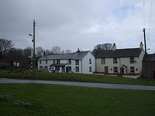
Bothel is a small village in Cumbria, England, historically within Cumberland. The village has a public house, and a primary school.

Ireby is a village in Cumbria, England, with a population of around 180. Historically it was in the county of Cumberland, since 1974 it has been in Cumbria.
Papcastle is a village and civil parish in the borough of Allerdale in the English county of Cumbria. The village is now effectively a northern extension of Cockermouth, which lies to the south of the River Derwent. It has its own parish council and lies within Bridekirk Parish for Church of England purposes. In 2001 it had a population of 406, reducing to 385 at the 2011 Census.

Isel is a dispersed settlement and area in the valley of the River Derwent within the Lake District National Park in Cumbria, England. It is an ecclesiastical parish within the civil parish of Blindcrake. Nearby are the hamlets of Setmurthy, Sunderland and Redmain, and the village of Blindcrake.
Uldale is a small village in Cumbria, England. It is about 5 miles (8 km) from Caldbeck, 2 miles (3 km) from Ireby with which it forms the civil parish of Ireby and Uldale together with Aughertree. The Uldale Fells are in the vicinity, and to the southeast are Chapelhouse Reservoir and Over Water. It is located just inside the Lake District National Park.

Caer Mote is a small hill in the north of the English Lake District near Bothel, Cumbria. Its summit at 920 feet (280 m) lies just outside the boundary of the Lake District National Park. It offers a view of Bassenthwaite Lake from its summit, upon which is an ancient earthwork enclosure of undetermined age, known as "The Battery". Under the name Caermote Hill it is the subject of a chapter of Wainwright's book The Outlying Fells of Lakeland. Wainwright's route is an ascent from Bothel via the northern summit St. John's Hill at 935 feet (285 m) in an anticlockwise circuit.

Mockerkin is a settlement in the English county of Cumbria. Historically part of Cumberland, it is situated just outside the Lake District National Park.

Sunderland is a hamlet and former civil parish, within the Lake District National Park, now in the parish of Blindcrake in the Allerdale district of the county of Cumbria, England, historically part of Cumberland.

Plumbland is a village and civil parish in the Allerdale district in the county of Cumbria, England. Situated towards the north west corner of the county, it is two miles from the outskirts of the Lake District National Park which is considered to be an Area of Outstanding Natural Beauty. The parish includes the hamlets of Threapland, Parsonby and Arkleby.

Parsonby is a hamlet in the Allerdale district of the English county of Cumbria. It is located on the B5301 road, south of Aspatria.

Aikshaw is a hamlet in the civil parish of Holme St. Cuthbert in Cumbria, United Kingdom. It is located approximately one-and-a-half miles north-west of the village of Westnewton, and three miles east of the village of Mawbray. Jericho is located approximately one mile to the east, with Edderside approximately a mile further to the south-east. Mealrigg is located half-a-mile to the south. Carlisle, Cumbria's county town, is located approximately twenty-two-and-a-half miles to the north-west. Aikshaw lies on the B5301 road, which runs from Silloth-on-Solway in the east via Tarns, Westnewton, and Aspatria to the A595 between Cockermouth and Bothel.
Bothel and Threapland is a civil parish in the Borough of Allerdale in Cumbria, England. It contains nine listed buildings that are recorded in the National Heritage List for England. All the listed buildings are designated at Grade II, the lowest of the three grades, which is applied to "buildings of national importance and special interest". The parish contains the villages of Bothel and Threapland, and is otherwise rural. Apart from a milestone, all the listed buildings are houses, farmhouses, or farm buildings.
Beacon Hill Community School is a coeducational secondary school located in Aspatria is the English county of Cumbria.


