Three Creek

Last updated
Three Creek
Tributary to Nottoway River
USA Virginia location map.svg
Red pog.svg
Location
CountryUnited States
StateVirginia
CountyGreensville
Southampton
Sussex
CityEmporia
Physical characteristics
SourceConfluence of Tryall Creek and Cooks Branch
  locationabout 2 miles north of Pleasant Shade, Virginia
  coordinates 36°47′16″N077°38′13″W / 36.78778°N 77.63694°W / 36.78778; -77.63694 [1]
  elevationabout 168 feet
Mouth confluence with the Nottoway River
  location
about 1/2 mile west of Sebrell, Virginia
  coordinates
36°46′53″N077°09′50″W / 36.78139°N 77.16389°W / 36.78139; -77.16389 [2]
  elevation
about 15 feet amsl
Length75.4 km/46.9 miles [3]
Basin features
Progressionroughly east
River system Nottoway River
Tributaries 
  leftCooks Branch
Reedy Branch
Cattail Creek
Uriah Branch
Browns Branch
Chatman Branch
Applewhite Swamp
Smith Swamp
Poplar Swamp
Hornet Swamp
  rightTryall Creek
Maclins Creek
Nicholson Creek
Angelico Creek
WaterbodiesSlagles Lake
BridgesGreensville County Routes 605, 613, 619, 610, 617, I-95, US 301, Greensville County Route 616, Sussex County Route 611, Southampton County Routes 615, 659, 308, 609 (Crichton Bridge)

Three Creek is a nearly 47 mile (75.4 km) long tributary of the Nottoway River in southeastern Virginia in the United States.

Nottoway River river in the United States of America

The Nottoway River is in southern Virginia and northeastern North Carolina. It is part of the Chowan River system, which flows into Albemarle Sound in North Carolina.

Virginia U.S. state in the United States

Virginia, officially the Commonwealth of Virginia, is a state in the Southeastern and Mid-Atlantic regions of the United States located between the Atlantic Coast and the Appalachian Mountains. The geography and climate of the Commonwealth are shaped by the Blue Ridge Mountains and the Chesapeake Bay, which provide habitat for much of its flora and fauna. The capital of the Commonwealth is Richmond; Virginia Beach is the most populous city, and Fairfax County is the most populous political subdivision. The Commonwealth's estimated population as of 2018 is over 8.5 million.

United States Federal republic in North America

The United States of America (USA), commonly known as the United States or America, is a country comprising 50 states, a federal district, five major self-governing territories, and various possessions. At 3.8 million square miles, the United States is the world's third or fourth largest country by total area and is slightly smaller than the entire continent of Europe, which is 3.9 million square miles. With a population of over 327 million people, the U.S. is the third most populous country. The capital is Washington, D.C., and the most populous city is New York City. Most of the country is located contiguously in North America between Canada and Mexico.

Contents

Course

Three Creek is formed at the confluence of Tryall Creek and Cooks Branch in Greensville County, Virginia. From the confluence, the creek flows east then south into Slagles Lake. After Slagles Lake it flows further south for about a mile and then flows roughly southeast and then northeast through swampland towards the Nottoway River. Three Creek forms the county boundary between Greensville and Sussex Counties for part of its course.

Greensville County, Virginia County in the United States

Greensville County is a county located in the Commonwealth of Virginia. As of the 2010 census, the population was 12,243. Its county seat is Emporia.

Sources

Tryall Creek rises from about 290 feet amsl near Pleasant Grove Church and flows northeast to meet Cooks Branch. Cooks Branch rises near Smoky Ordinary at about 315 feet amsl and flows east then south to meet with Tryall Creek. Cooks Branch has one tributary called Kettlestick Branch that comes in on the left. [4]

Watershed

Three Creek drains a mostly forested watershed and contains a lot of swampland towards the Nottoway River. Agriculture makes a large amount of the rest of the area. [5]

River Modifications

Three Creek has one impoundment, Slagles Lake along its course. A number of the tributaries have their own impoundments.

Geology

The confluence of Tryall Creek and Cooks Branch is in the Piedmont of Virginia in mafic and felsic metavolcanic rocks. Both tributaries arise in granite (Tryall Creek) or granite gneiss (Cooks Branch). Three Creek flows into the Coastal Plain in the Bacon Castle Formation and then for most of its length, especially the swampy areas it is in alluvium. [6]

Piedmont (United States) plateau region located in the eastern United States

The Piedmont is a plateau region located in the Eastern United States. It sits between the Atlantic coastal plain and the main Appalachian Mountains, stretching from New York in the north to central Alabama in the south. The Piedmont Province is a physiographic province of the larger Appalachian division which consists of the Gettysburg-Newark Lowlands, the Piedmont Upland and the Piedmont Lowlands sections.

Granite A common type of intrusive, felsic, igneous rock with granular structure

Granite is a common type of felsic intrusive igneous rock that is granular and phaneritic in texture. Granites can be predominantly white, pink, or gray in color, depending on their mineralogy. The word "granite" comes from the Latin granum, a grain, in reference to the coarse-grained structure of such a holocrystalline rock. Strictly speaking, granite is an igneous rock with between 20% and 60% quartz by volume, and at least 35% of the total feldspar consisting of alkali feldspar, although commonly the term "granite" is used to refer to a wider range of coarse-grained igneous rocks containing quartz and feldspar.

See also

Related Research Articles

Cullasaja River Stream in North Carolina, USA

The Cullasaja River is a short river located entirely in Macon County, North Carolina. It is a tributary of the Little Tennessee River, into which it flows near the county seat of Franklin. It originates to the southeast, near Highlands, the county's only other town. It flows from manmade Lake Sequoyah, which is fed by Mirror Lake and other creeks and streams originating on the western side of the Eastern Continental Divide, which runs through the east side of Highlands.

Marshyhope Creek river in the United States of America


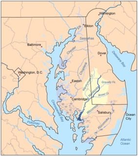
Marshyhope Creek is a 37.0-mile-long (59.5 km) tributary of the Nanticoke River on the Delmarva Peninsula. It rises in Kent County, Delaware, and runs through Caroline County, Maryland, and Dorchester County, Maryland.

Shenango River Stream in Pennsylvania, USA

The Shenango River is a principal tributary of the Beaver River, approximately 100 mi (160 km) long, in western Pennsylvania in the United States. It also briefly flows through small portions of northeastern Ohio. Via the Beaver and Ohio Rivers, it is part of the watershed of the Mississippi River.

Laurel Hill Creek Stream in Pennsylvania, USA

Laurel Hill Creek is a 39.9-mile-long (64.2 km) tributary of the Casselman River in Somerset County, Pennsylvania, in the United States.

Oil Creek (Allegheny River tributary) river in the United States of America

Oil Creek is a 46.7-mile (75.2 km) tributary of the Allegheny River in Venango and Crawford counties in the U.S. state of Pennsylvania. It has a drainage area of 319 square miles (830 km2) and joins the Allegheny at Oil City. Attractions along the river include the Drake Well Museum and Oil Creek State Park. The stream was named after the oil that was found along its banks before the historic oil strike by Edwin Drake in Titusville, which Oil Creek flows through. Oil Creek is popular with canoeists and fishers. The creek is rated as a beginners creek for those interested in learning how to safely use canoes and kayaks. Oil Creek is a cold water fishery with bass and trout living in its waters.

Little Nottoway River river in the United States of America

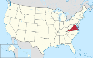
The Little Nottoway River is a 14.31 mi (23.03 km) long tributary to the Nottoway River in the United States state of Virginia. Located in the southeastern part of the state, it is part of the larger Chowan-Albemarle drainage.

Rowanty Creek river in the United States of America

Rowanty Creek is a 14-mile long creek that is a tributary to the Nottoway River in southeastern Virginia. It is formed at the confluence of Hatcher Run and Gravelly Run.

Stony Creek (Virginia) river in United States of America

Stony Creek is a 21 mile long tributary to the Nottoway River in southeastern Virginia of the United States. The creek is formed by the confluence of Butterwood Creek and White Oak Creek in Dinwiddie County, Virginia.

Contentnea Creek Stream in North Carolina, USA

Contentnea Creek is tributary of the Neuse River in North Carolina, USA. It is part of the Neuse River Basin, and flows for 91 miles between the Buckhorn Reservoir, where it begins, and Grifton, North Carolina, where it flows into the Neuse River.

East Branch Oil Creek (Oil Creek tributary)

East Branch Oil Creek is a 10.9-mile long tributary to Oil Creek in Crawford County, Pennsylvania.

Neshannock Creek (Shenango River tributary) Stream in Pennsylvania, USA

Neshannock Creek is a 25.65 mi (41.28 km) long tributary to Shenango River that forms at the confluence of Cool Spring and Otter Creek in Mercer County and then flows south to Lawrence County, Pennsylvania. This creek is known for its fly fishing at Volant, Pennsylvania.

Chapel Branch (Lewes Creek tributary) Stream in Delaware, USA

Chapel Branch is a 6.4 mi (10.3 km) long tributary to Lewes Creek in Sussex County, Delaware. Lewes Creek then flows into the Nanticoke River.

Houston Branch (Marshyhope Creek tributary) Stream in Delaware, USA

Houston Branch is a 10.26 mi (16.51 km) long tributary to Marshyhope Creek that rises in western Sussex County, Delaware and flows west into Caroline County, Maryland.

Tanyard Branch (Marshyhope Creek tributary) Stream in Delaware, USA

Tanyard Branch is a 4.96 mi (7.98 km) long tributary to Marshyhope Creek that rises in western Sussex County, Delaware and flows west into Caroline County, Maryland.

Jacks Branch (Little Nottoway River tributary)

The Jacks Branch is a 2.92 mi (4.70 km) long tributary to the Little Nottoway River in the United States state of Virginia. Located in the southeastern part of the state, it is part of the larger Chowan-Albemarle drainage. The watershed is 61% forested and 26% agricultural with the rest of land as other uses.

Whetstone Creek (Little Nottoway River tributary)

The Whetstone Creek is a 10.54 mi (16.96 km) long tributary to the Little Nottoway River in the United States state of Virginia. Located in the southeastern part of the state, it is part of the larger Chowan-Albemarle drainage. The watershed is 65% forested and 32% agricultural with the rest of land as other uses.

Long Branch (Little Nottoway River tributary)

The Long Branch is a 3.44 mi (5.54 km) long tributary to the Little Nottoway River in the United States state of Virginia. Located in the southeastern part of the state, it is part of the larger Chowan-Albemarle drainage. The watershed is 58% forested and 38% agricultural with the rest of land as other uses.

Lazaretto Creek (Little Nottoway River tributary) American river

Lazaretto Creek is a 8.89 mi (14.31 km) long tributary to the Little Nottoway River in the United States state of Virginia. Located in the south-central part of the state, it is part of the larger Chowan-Albemarle drainage. The watershed is 51% forested and 39% agricultural with the rest of land as other uses.

Mallorys Creek (Little Nottoway River tributary) American river

The Mallorys Creek is a 7.10 mi (11.43 km) long tributary to the Little Nottoway River in the United States state of Virginia. Located in the south-central part of the state, it is part of the larger Chowan-Albemarle drainage. The watershed is 54% forested and 39% agricultural with the rest of land as other uses. This stream joins with Carys Creek to form the Little Nottoway River.

Carys Creek (Little Nottoway River tributary) American river

Carys Creek is a 7.06 mi (11.36 km) long tributary to the Little Nottoway River in the United States state of Virginia. Located in the south-central part of the state, it is part of the larger Chowan-Albemarle drainage. The watershed is 74% forested and 25% agricultural with the rest of land as other uses. This stream joins with Carys Creek to form the Little Nottoway River.

References

  1. "GNIS Detail - Three Creek". geonames.usgs.gov. US Geological Survey. Retrieved 2 June 2019.
  2. "GNIS Detail - Three Creek". geonames.usgs.gov. US Geological Survey. Retrieved 2 June 2019.
  3. "ArcGIS Web Application". epa.maps.arcgis.com. US EPA. Retrieved 2 June 2019.
  4. "Butterwood Lake Topo Map, Nottoway County VA (Blackstone East Area)". TopoZone. Locality, LLC. Retrieved 3 June 2019.
  5. "THREE CREEK, MILL SWAMP, AND DARDEN MILL RUN WATERSHEDS TMDL IMPLEMENTATION PLAN TECHNICAL REPORT" (PDF). Virginia Dept. of Environmental Quality. Retrieved 3 June 2019.
  6. "ArcGIS Web Application". www.dmme.virginia.gov. Virginia Division of Geology and Mineral Resources. Retrieved 3 June 2019.
International Standard Book Number Unique numeric book identifier

The International Standard Book Number (ISBN) is a numeric commercial book identifier which is intended to be unique. Publishers purchase ISBNs from an affiliate of the International ISBN Agency.