
The Sturt Highway is an Australian national highway in New South Wales, Victoria, and South Australia. The Sturt Highway is an important road link for the transport of passengers and freight between Sydney and Adelaide and the regions situated adjacent to the route.

A bascule bridge is a moveable bridge with a counterweight that continuously balances a span, or leaf, throughout its upward swing to provide clearance for boat traffic. It may be single- or double-leafed.

The Port River is part of a tidal estuary located north of the Adelaide city centre in the Australian state of South Australia. It has been used as a shipping channel since the beginning of European settlement of South Australia in 1836, when Colonel Light selected the site to use as a port. Before colonisation, the Port River region and the estuary area were known as Yerta Bulti by the Kaurna people, and used extensively as a source of food and plant materials to fashion artefacts used in daily life.
Port Wakefield Road and Port Wakefield Highway are an important South Australian highway. They connect Adelaide to the Yorke Peninsula, Port Augusta, northern and western South Australia, the Northern Territory and Western Australia. They are designated National Highway A1 and a part of the National Highway. They are named after Port Wakefield, the first government town north of Adelaide. Historically, the whole route was named Port Wakefield Road, however following the opening of the Northern Expressway, the route north of that junction was named Port Wakefield Highway.
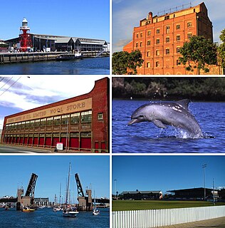
Port Adelaide is a port-side region of Adelaide, approximately 14 kilometres (8.7 mi) northwest of the Adelaide CBD. It is also the namesake of the City of Port Adelaide Enfield council, a suburb, a federal and state electoral division and is the main port for the city of Adelaide. Port Adelaide played an important role in the formative decades of Adelaide and South Australia, with the port being early Adelaide's main supply and information link to the rest of the world. Its Kaurna name, although not officially adopted as a dual name, is Yartapuulti.

Taperoo is a suburb in the Australian state of South Australia located on the LeFevre Peninsula in the west of Adelaide about 18 kilometres (11 mi) north-west of the Adelaide city centre.
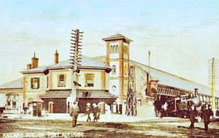
Port Dock railway station – named Port Adelaide until 1916 – was located in the commercial centre of Port Adelaide, South Australia at the corner of St Vincent Street and Lipson Street. It was the original terminus of the railway between Adelaide and Port Adelaide, which opened in 1856.

The Dry Creek–Port Adelaide railway line is an eight-kilometre east–west line running through Adelaide's north-western suburbs. The line is managed by the Australian Rail Track Corporation (ARTC) and is an important link between Port Adelaide, Pelican Point and the main interstate rail routes which link Adelaide with Melbourne, Perth, Darwin and Sydney. Prior to 1988, a limited local passenger service operated, stopping at five intermediate stations along the line. Since May 1988, the line has been freight-only.
Outer Harbor is a suburb in the Australian state of South Australia located at the northern tip of the Lefevre Peninsula about 22 kilometres (14 mi) north-west of the Adelaide city centre.
Birkenhead is a north-western suburb of Adelaide 14 km from the CBD, on the Lefevre Peninsula, in South Australia, and lies within the City of Port Adelaide Enfield. It is adjacent to Peterhead, Exeter and Glanville. It is bounded to the south by the Gawler Reach of the Port River, to the north by Hargrave Street and in the west and east by the Outer Harbor railway line and the Port River respectively.
The Port River Expressway is a 5.5-kilometre (3.4 mi) freeway-grade road. The expressway links Port Adelaide and the LeFevre Peninsula to the northern suburbs of Adelaide and major interstate routes via Salisbury Highway (A9) to Port Wakefield Road (A1) and the Max Fatchen Northern Expressway (M2) to Perth, Darwin and Sydney.

The Grafton Bridge is a heritage-listed bascule truss bridge that carries the Bent Street and North Coast railway line across the Clarence River in Grafton, New South Wales, Australia. The bridge links the Grafton central business district with South Grafton, and was added to the New South Wales State Heritage Register on 2 April 1999.
Portside Messenger is a weekly suburban newspaper in Adelaide, part of the Messenger Newspapers group. The Portside covers the entire Le Fevre Peninsula, taking in Adelaide's northern metropolitan beach suburbs, and all of Port Adelaide.
The Adelaide-Port Augusta railway line is the primary rail corridor in South Australia for northbound rail traffic out of Adelaide. The line, 315 kilometres long, forms part of the Perth–Adelaide and Adelaide–Darwin rail route, and the portion south of Crystal Brook forms part of the Adelaide–Sydney rail route.

The North–South Motorway is an incomplete planned motorway traversing the inner western suburbs of Adelaide from Waterloo Corner in the north to Bedford Park in the south. Progressively constructed in stages since 2010, once complete it will replace the adjacent South Road as Adelaide's main north-south roadway and form the central section of the North–South Corridor, being flanked north and south by the Northern Expressway and Southern Expressway, respectively.

Abigroup was an Australian construction company.

The Stuart O'Grady Bikeway is a 23 kilometres (14 mi) shared path in the northern suburbs of Adelaide, following the eastern side of the Max Fatchen Expressway. The northeastern end is adjacent to the on ramp from Two Wells Road to the Gawler Bypass Road. The southwestern end is adjacent to Port Wakefield Road. It is named after Stuart O'Grady.
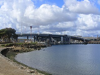
The Jervois Bridge is a bridge in Greater Adelaide, Australia that crosses the Port River.

The Mary MacKillop Bridge is a bascule bridge in Adelaide, Australia that carries the Dry Creek-Port Adelaide railway line over the Port River.


