Toro District

Last updated
Toro
T'uru
District

Sipia.jpg

Cascade of Sipia, Toro district
Country Flag of Peru.svg  Peru
Region Arequipa
Province La Unión
Founded May 4, 1835
Capital Toro
Government
   Mayor Francisco Elias Tapia Martinez
Area
  Total 391.44 km2 (151.14 sq mi)
Elevation 2,964 m (9,724 ft)
Population (2005 census)
  Total 1,205
  Density 3.1/km2 (8.0/sq mi)
Time zone PET (UTC-5)
UBIGEO 040811

Toro District is one of eleven districts of the province La Unión in Peru. [1]

Districts of Peru third level administrative subdivision of Peru

The districts of Peru are the third-level country subdivisions of Peru. They are subdivisions of the provinces, which in turn are subdivisions of the larger regions or departments. There are 1,838 districts in total.

La Unión Province, Peru Province in Arequipa, Peru

La Unión is a province of the Arequipa Region in Peru. Its seat is Cotahuasi.

Peru republic in South America

Peru, officially the Republic of Peru, is a country in western South America. It is bordered in the north by Ecuador and Colombia, in the east by Brazil, in the southeast by Bolivia, in the south by Chile, and in the west by the Pacific Ocean. Peru is a megadiverse country with habitats ranging from the arid plains of the Pacific coastal region in the west to the peaks of the Andes mountains vertically extending from the north to the southeast of the country to the tropical Amazon Basin rainforest in the east with the Amazon river.

Geography

One of the highest peaks of the district is Sulimana at 6,093 m (19,990 ft). Other mountains are listed below: [2]

Related Research Articles

Huanca Sancos Province Province in Ayacucho, Peru

Huanca Sancos is a province in central Ayacucho, Peru. On April 3, 1983, Shining Path rebels entered the town of Lucanamarca and killed 69 people.

Paucar del Sara Sara Province Province in Ayacucho, Peru

Paucar del Sara Sara Province is a province located in the south-eastern corner of the Ayacucho Region of Peru. It is one of eleven provinces that make up the region. The province has a population of 10,610 inhabitants 2005 census. It is bounded to the north and west by the Parinacochas Province and to the south and east by the Arequipa Region. The capital of this province is the city of Pausa.

Chumbivilcas Province Province in Cusco, Peru

Chumbivilcas(3D-map) is a province in the Andes in South Peru. The Inca called it "Chumpiwillka". The seat of the province is Santo Tomás. Officially Chumbivilcas was founded on June 21, 1825.

Cangallo Province Province in Ayacucho, Peru

The Cangallo Province is a province located in the Ayacucho Region of Peru. It is one of the eleven that make up the region. The province has a population of 36,977 inhabitants as of census 2005. The capital of the province is the city of Cangallo.

Parinacochas Province Province in Ayacucho, Peru

The Parinacochas Province is a province located in the Ayacucho Region of Peru. It is one of the eleven that make up that region. The province has a population of 24,028 inhabitants as of 2002. The capital of the province is Coracora.

Antabamba Province Province in Apurímac, Peru

Antabamba Province is one of the seven provinces of the Apurímac Region in Peru. The capital of the province is the city of Antabamba.

Huancavelica Province Province in Huancavelica, Peru

The Huancavelica Province is one of seven provinces located in the Huancavelica Region of Peru. The capital of this province is the city of Huancavelica.

Calca Province Province in Cusco, Peru

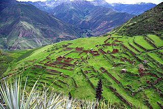
Calca Province is one of thirteen provinces in the Cusco Region in the southern highlands of Peru. Its seat is Calca.

Canchis Province Province in Cusco, Peru

Canchis Province is one of thirteen provinces in the Cusco Region in the southern highlands of Peru.

Quispicanchi Province Province in Cusco, Peru

Quispicanchi Province is one of thirteen provinces in the Cusco Region in the southern highlands of Peru.

Caylloma Province Province in Arequipa, Peru

Caylloma Province is the largest of eight provinces in the Arequipa Region of Peru.

Ocongate District District in Cusco, Peru

The Ocongate District is one of the twelve districts in the Quispicanchi Province in Peru. Created on January 2, 1857, its capital is the town of Ocongate.

Oropesa District is one of the seven districts of the province Antabamba in Peru.

Otoca District is one of twenty-one districts of the Lucanas Province in Peru.

Ollachea District is one of ten districts of the province Carabaya in Peru.

Calca District District in Cusco, Peru

Calca District is one of eight districts of the province Calca in Peru.

Pitumarca District District in Cusco, Peru

Pitumarca District is one of eight districts of the province Canchis in Peru.

Santo Tomás District is one of eight districts of the province Chumbivilcas in Peru.

Pilpichaca District is one of sixteen districts of the province Huaytará in Peru.

References

  1. (in Spanish) Instituto Nacional de Estadística e Informática. Banco de Información Distrital . Retrieved April 11, 2008.
  2. escale.minedu.gob.pe/ UGEL map La Unión Province (Arequipa Region)

Coordinates: 15°15′52″S72°55′33″W / 15.2644°S 72.9258°W / -15.2644; -72.9258

Geographic coordinate system Coordinate system

A geographic coordinate system is a coordinate system that enables every location on Earth to be specified by a set of numbers, letters or symbols. The coordinates are often chosen such that one of the numbers represents a vertical position and two or three of the numbers represent a horizontal position; alternatively, a geographic position may be expressed in a combined three-dimensional Cartesian vector. A common choice of coordinates is latitude, longitude and elevation. To specify a location on a plane requires a map projection.