Syenite is a coarse-grained intrusive igneous rock with a general composition similar to that of granite, but deficient in quartz, which, if present at all, occurs in relatively small concentrations. Some syenites contain larger proportions of mafic components and smaller amounts of felsic material than most granites; those are classed as being of intermediate composition. The volcanic equivalent of syenite is trachyte.
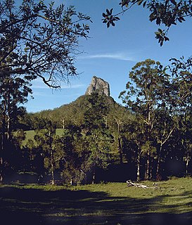
Glass House Mountains National Park is a heritage-listed national park at Glass House Mountains, Sunshine Coast Region, Queensland, Australia. It is also known as Beerburrum Forest Reserve 1. It is 70 km (43 mi) north of Brisbane and consists of a flat plain punctuated by rhyolite and trachyte volcanic plugs, the cores of extinct volcanoes that formed 27 million to 26 million years ago. The mountains would once have had pyroclastic exteriors, but these have eroded away.
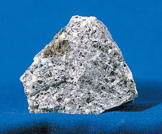
Trachyte is an extrusive igneous rock composed mostly of alkali feldspar. It is usually light-colored and fine-grained, with minor amounts of mafic minerals, and is formed by the rapid cooling of lava enriched with silica and alkali metals. It is the volcanic equivalent of syenite.

Monselice is a town and municipality (comune) located in northeastern Italy, in the Veneto region, in the province of Padua.

Königswinter is a city and summer resort in the Rhein-Sieg district, in North Rhine-Westphalia, Germany.

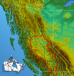
The Clear Range is a small mountain range located in the angle of the Fraser and Thompson Rivers in south-central British Columbia. It has a small subdivision just northeast of that confluence named the Scarped Range. The Clear Range totals 16,270 km² (6,280 mi²) and is 75 km (47 mi) north to south and 35 km (22 mi) east to west. The Clear Range and its northward neighbour the Marble Range are both subranges of the Pavilion Range.
The Interior Plateau comprises a large region of the Interior of British Columbia, and lies between the Cariboo and Monashee Mountains on the east, and the Hazelton Mountains, Coast Mountains and Cascade Range on the west. The continuation of the plateau into the United States is known there as the Columbia Plateau.
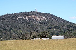
Mount Gibraltar is a mountain with an elevation of 863 metres (2,831 ft) AHD that is located in the Southern Highlands region, between Bowral and Mittagong, in New South Wales, Australia. Further west is Berrima.

The Itcha Range, also known as the Itchas, is a small isolated mountain range in the West-Central Interior of British Columbia, Canada. It is located 40 km (25 mi) northeast of the community of Anahim Lake. With a maximum elevation of 2,375 m (7,792 ft), it is the lowest of three mountain ranges on the Chilcotin Plateau extending east from the Coast Mountains. Two mountains are named in the Itcha Range; Mount Downton and Itcha Mountain. A large provincial park surrounds the Itcha Range and other features in its vicinity. More than 15 animal species are known to exist in the Itcha Range area, as well as a grassland community that is limited only to this location of British Columbia. The Itcha Range is within territory which has been occupied by aboriginal peoples for millennia. This area has a relatively dry environment compared to the Coast Mountains in the west.
Shell Glacier is a western lobe of the Mount Bird icecap. It descends steeply in the valley north of Trachyte Hill and Harrison Bluff in the center of the ice-free area on the lower western slopes of Mount Bird, Ross Island. Mapped and so named by the New Zealand Geological Survey Antarctic Expedition (NZGSAE), 1958–59, because of the marine shell content of the moraines.

Maitland Volcano is a heavily eroded shield volcano in the Northern Interior of British Columbia, Canada. It is 83 km (52 mi) southeast of the small community of Telegraph Creek in what is now the Klappan Range of the northern Skeena Mountains. This multi-vent volcano covered a remarkably large area and was topped by a younger volcanic edifice. Little remains of Maitland Volcano today, limited only to eroded lava flows and distinctive upstanding landforms created when magma hardened within the vents of the volcano.

The Mount Edziza volcanic complex is a large and potentially active north-south trending complex volcano in Stikine Country, northwestern British Columbia, Canada, located 38 kilometres (24 mi) southeast of the small community of Telegraph Creek. It occupies the southeastern portion of the Tahltan Highland, an upland area of plateau and lower mountain ranges, lying east of the Boundary Ranges and south of the Inklin River, which is the east fork of the Taku River. As a volcanic complex, it consists of many types of volcanoes, including shield volcanoes, calderas, lava domes, stratovolcanoes, and cinder cones.
Pavilion Mountain is a mountain in the Marble Range in the South Cariboo region of the South-Central Interior of British Columbia, Canada, located northeast of the ranching and First Nations community of Pavilion and to the north of Marble Canyon and immediately south of Kelly Lake, which is the focus of Downing Provincial Park. The term Pavilion Mountain is also used to refer to the historic ranch and associated rangeland on the "bench" on the mountain's southwestern side, and also to the road which traverses that benchland and the mountain's western shoulder and is the route of the Old Cariboo Road. The switchback descent from the summit of the road was known as the Rattlesnake Grade and was an infamous stretch of the old wagon road. From a junction at the road-summit, a road leads east along the spine of the mountain to the peak, which is the site of a microwave relay and former fire lookout. The mountain's only named subpeak, Mount Carson, at 2005 metres, is southeast of the fire lookout and is named for the original owner of the ranch and was briefly misapplied as the name of Pavilion Mountain. Robert Carson was one of the first settlers in the region and whose sons later became prominent MLAs and provincial cabinet ministers. The north wall of Marble Canyon is essentially the southeast buttress of Pavilion Mountain.
The Satah Mountain volcanic field (SMVF) is an extensive north-south trending volcanic chain in the Central Interior of British Columbia that stretches south of the Itcha Range shield volcano to northeast of Nimpo Lake. The chain is located on the Chilcotin Plateau, a major subdivision of the Interior Plateau that includes other nearby volcanic features. It forms a segment of the east-west trending Anahim Volcanic Belt, whose volcanic activity ranges in age from Miocene-to-Holocene. Volcanic features in the Satah Mountain field include lava domes, cinder cones and lava flows. Its name originates from Satah Mountain, the highest volcano, located 35 km (22 mi) northeast of Nimpo Lake.
Trachyte Hill is a prominent hill, 470 m, just south of Shell Glacier in the center of the ice-free area on the lower west slopes of Mount Bird on Ross Island. Mapped and so named by the New Zealand Geological Survey Antarctic Expedition (NZGSAE), 1958–59, because of the rock type composing the hill.
Harrison Bluff is a pale-colored trachyte headland forming the seaward termination of Trachyte Hill and marking the southern end of McDonald Beach on the western side of Mount Bird, Ross Island, Antarctica. Many skuas nest on the bluff. A survey station marked by a rock cairn was placed on the top of the northwest corner of the bluff by E.B. Fitzgerald of the Cape Bird party of the New Zealand Geological Survey Antarctic Expedition, 1958–59, and the bluff was named by the New Zealand Antarctic Place-Names Committee for J. Harrison, mountaineer-assistant with the expedition.
Trachyte is a volcanic rock.

Keratophyre is a volcanic rock of intermediate composition. Although similar to trachyte, keratophyre's plagioclase component is richer in sodium than the plagioclase found in trachyte. Keratophyre forms lava flows and subvolcanic intrusions. Keratophyre occurs, for example, at Hüttenrode in the Harz Mountains of Germany and in the Berwyn Hills of Wales. Keratophyre tuff of Early Devonian age occurs in Sauerland (Germany).
Baldface Mountain is a conical butte-like summit in the West-Central Interior of British Columbia, Canada. It is east of Itcha Lake and northeast of the community of Anahim Lake.

The geology of Ascension Island is the geologically young, exposed part of a large volcano, 80 kilometers west of the Mid-Atlantic Ridge. The island formed within the last six to seven million years and is primarily mafic rock with some felsic rock.