
Smart growth is an urban planning and transportation theory that concentrates growth in compact walkable urban centers to avoid sprawl. It also advocates compact, transit-oriented, walkable, bicycle-friendly land use, including neighborhood schools, complete streets, and mixed-use development with a range of housing choices. The term "smart growth" is particularly used in North America. In Europe and particularly the UK, the terms "compact city", "urban densification" or "urban intensification" have often been used to describe similar concepts, which have influenced government planning policies in the UK, the Netherlands and several other European countries.

Transportation in Israel is based mainly on private motor vehicles and bus service and an expanding railway network. A lack of inland waterways and the small size of the country make air and water transport of only minor importance in domestic transportation, but they are vitally important for Israel's international transport links. Demands of population growth, political factors, the Israel Defense Forces, tourism and increased traffic set the pace for all sectors, being a major driver in the mobility transition towards railways and public transit while moving away from motorized road transport. All facets of transportation in Israel are under the supervision of the Ministry of Transport and Road Safety.
New Urbanism is an urban design movement that promotes environmentally friendly habits by creating walkable neighbourhoods containing a wide range of housing and job types. It arose in the United States in the early 1980s, and has gradually influenced many aspects of real estate development, urban planning, and municipal land-use strategies. New Urbanism attempts to address the ills associated with urban sprawl and post-Second World War suburban development.
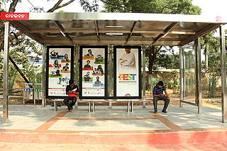
A bus stop is a place where buses stop for passengers to get on and off the bus. The construction of bus stops tends to reflect the level of usage, where stops at busy locations may have shelters, seating, and possibly electronic passenger information systems; less busy stops may use a simple pole and flag to mark the location. Bus stops are, in some locations, clustered together into transport hubs allowing interchange between routes from nearby stops and with other public transport modes to maximise convenience.

Edge city is a term that originated in the United States for a concentration of business, shopping, and entertainment outside a traditional downtown or central business district, in what had previously been a suburban residential or rural area. The term was popularized by the 1991 book Edge City: Life on the New Frontier by Joel Garreau, who established its current meaning while working as a reporter for The Washington Post. Garreau argues that the edge city has become the standard form of urban growth worldwide, representing a 20th-century urban form unlike that of the 19th-century central downtown. Other terms for these areas include suburban activity centers, megacenters, and suburban business districts. These districts have now developed in many countries.

A park and ride, also known as incentive parking or a commuter lot, is a parking lot with public transport connections that allows commuters and other people heading to city centres to leave their vehicles and transfer to a bus, rail system, or carpool for the remainder of the journey. The vehicle is left in the parking lot during the day and retrieved when the owner returns. Park and rides are generally located in the suburbs of metropolitan areas or on the outer edges of large cities. A park and ride that only offers parking for meeting a carpool and not connections to public transport may also be called a park and pool.
In urban planning, transit-oriented development (TOD) is a type of urban development that maximizes the amount of residential, business and leisure space within walking distance of public transport. It promotes a symbiotic relationship between dense, compact urban form and public transport use. In doing so, TOD aims to increase public transport ridership by reducing the use of private cars and by promoting sustainable urban growth.

Intermodal passenger transport, also called mixed-mode commuting, involves using two or more modes of transportation in a journey. Mixed-mode commuting is often used to combine the strengths of various transportation options. A major goal of modern intermodal passenger transport is to reduce dependence on the automobile as the major mode of ground transportation and increase use of public transport. To assist the traveller, various intermodal journey planners such as Rome2rio and Google Transit have been devised to help travellers plan and schedule their journey.
Public transport planning or transit planning is the spatial planning professional discipline responsible for developing public transport systems. It is a hybrid discipline involving aspects of transport engineering and traditional urban planning. Indeed, many transit planners find themselves involved in discourse with urban-land-use issues such as transit-oriented development.
Principles of intelligent urbanism (PIU) is a theory of urban planning composed of a set of ten axioms intended to guide the formulation of city plans and urban designs. They are intended to reconcile and integrate diverse urban planning and management concerns. These axioms include environmental sustainability, heritage conservation, appropriate technology, infrastructure-efficiency, placemaking, social access, transit-oriented development, regional integration, human scale, and institutional integrity. The term was coined by Prof. Christopher Charles Benninger.

A transit village is a pedestrian-friendly mixed-use district or neighborhood oriented around the station of a high-quality transit system, such as rail or B.R.T. Often a civic square of public space abuts the train station, functioning as the hub or centerpiece of the surrounding community and encouraging social interaction. While mainly residential in nature, many transit villages offer convenience retail and services to residents heading to and from train stations.

Bicycle parking is part of the cycling infrastructure of a populated place allowing for the storage of bicycles when they are not being used. Parking facilities for bicycles include racks, lockers, parking stations, and covered areas. Bicycle parking infrastructure, in addition to cyclists' equipment such bicycle locks, offers a degree of security and may prevent bicycle theft. Ad hoc bicycle parking alongside railings, signs, and other street furniture is a common practice and may be recognized through formal legal arrangements.

MLK Jr. station is a DART Light Rail station in Dallas, Texas. It is situated in South Dallas and serves the Green Line. MLK Jr. station acts as a transfer point to numerous buses at the nearby J.B. Jackson Jr. Transit Center. Since opening in 2009, ridership has grown substantially to 1,153 riders each weekday.
Activity centre is a term used in urban planning and design for a mixed-use urban area where there is a concentration of commercial and other land uses. For example, the central business districts of cities (CBD) are also known as “Central Activities Districts” (CAD) (also known as Downtown in North America or "Central Activities Zone" in the United Kingdom in recognition of the fact that commercial functions are not the only things that occur there. The term activity centre can also be used to designate an area for mixed-use development, whatever its current land use happens to be.
Urban consolidation describes the policy of constraining further development and population growth to within the boundaries of preexisting urban areas rather than expanding outward into suburban areas. Urban consolidation seeks to increase the population density of a given urban area by expanding upward, redeveloping preexisting buildings and lots, and constructing new facilities in available spaces. It is theorized that discouraging urban sprawl and encouraging further development of housing units in preexisting urban areas will lead to a net gain in social and economic prosperity.
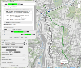
A journey planner, trip planner, or route planner is a specialized search engine used to find an optimal means of travelling between two or more given locations, sometimes using more than one transport mode. Searches may be optimized on different criteria, for example fastest, shortest, fewest changes, cheapest. They may be constrained, for example, to leave or arrive at a certain time, to avoid certain waypoints, etc. A single journey may use a sequence of several modes of transport, meaning the system may know about public transport services as well as transport networks for private transportation. Trip planning or journey planning is sometimes distinguished from route planning, which is typically thought of as using private modes of transportation such as cycling, driving, or walking, normally using a single mode at a time. Trip or journey planning, in contrast, would make use of at least one public transport mode which operates according to published schedules; given that public transport services only depart at specific times, an algorithm must therefore not only find a path to a destination, but seek to optimize it so as to minimize the waiting time incurred for each leg. In European Standards such as Transmodel, trip planning is used specifically to describe the planning of a route for a passenger, to avoid confusion with the completely separate process of planning the operational journeys to be made by public transport vehicles on which such trips are made.

A pedestrian village is a compact, pedestrian-oriented neighborhood or town with a mixed-use village center. Shared-use lanes for pedestrians and those using bicycles, Segways, wheelchairs, and other small rolling conveyances that do not use internal combustion engines. Generally, these lanes are in front of the houses and businesses, and streets for motor vehicles are always at the rear. Some pedestrian villages might be nearly car-free with cars either hidden below the buildings, or on the boundary of the village. Venice, Italy is essentially a pedestrian village with canals. Other examples of a pedestrian village include Giethoorn village located in the Dutch province of Overijssel, Netherlands, Mont-Tremblant Pedestrian Village located beside Mont-Tremblant, Quebec, Canada, and Culdesac Tempe in Tempe, Arizona.

Rapid transit or mass rapid transit (MRT), also known as heavy rail or metro, is a type of high-capacity public transport that is generally built in urban areas. A rapid transit system that primarily or traditionally runs below the surface may be called a subway, tube, or underground. Unlike buses or trams, rapid transit systems are railways, usually electric, that operate on an exclusive right-of-way, which cannot be accessed by pedestrians or other vehicles. They are often grade-separated in tunnels or on elevated railways.

Public transport is a system of transport for passengers by group travel systems available for use by the general public unlike private transport, typically managed on a schedule, operated on established routes, and that charge a posted fee for each trip. There is no rigid definition of which kinds of transport are included, and air travel is often not thought of when discussing public transport—dictionaries use wording like "buses, trains, etc." Examples of public transport include city buses, trolleybuses, trams and passenger trains, rapid transit and ferries. Public transport between cities is dominated by airlines, coaches, and intercity rail. High-speed rail networks are being developed in many parts of the world.

Bus rapid transit in New Jersey comprises limited-stop bus service, exclusive bus lanes (XBL) and bus bypass shoulders (BBS). Under the banner Next Generation Bus New Jersey Transit (NJT), the New Jersey Department of Transportation (NJDOT), and the metropolitan planning organizations of New Jersey (MPO) which recommend and authorize transportation projects are undertaking the creation of several additional bus rapid transit systems (BRT) in the state.
