Chatfield Hollow State Park is a public recreation area occupying 412 acres (167 ha) that lie adjacent to Cockaponset State Forest in the town of Killingworth, Connecticut. The state park offers hiking trails, a swimming beach, trout fishing, mountain biking, rock climbing, and picnicking areas. Park attractions include 6.67-acre (2.70 ha) Schreeder Pond, Indian caves, historic sites, a restored water wheel, and a reproduction covered bridge. The park is managed by the Connecticut Department of Energy and Environmental Protection.

The Saugatuck River is a 23.7-mile-long (38.1 km) river in southwestern Connecticut in the United States. It drains part of suburban and rural Fairfield County west of Bridgeport, emptying into Long Island Sound.
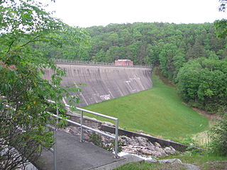
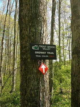
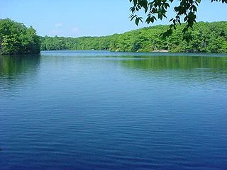
The Saugatuck Reservoir is a reservoir in Fairfield County, Connecticut, US, that straddles the border between the towns of Redding and Weston. It is created by the Samuel P. Senior dam of the Saugatuck River, and provides water to several of the surrounding towns. It is considered quite scenic and is stocked with trout for fishing. It borders the Trout Brook Valley State Park Reserve at the southeast.
Millers Pond State Park is a public recreation area lying adjacent to Cockaponset State Forest in the towns of Durham and Haddam, Connecticut. The park's central feature is 33-acre (13 ha) Millers Pond, whose principal source of water is large springs that create a body of unpolluted water excellent for trout and smallmouth bass. The park offers fishing, hiking, mountain biking, and hunting.
Aspetuck is a village, which in Connecticut is an unincorporated community on the Aspetuck River, in Fairfield County, Connecticut, mostly in the town of Easton but extending also into Weston. It is significant for being the location of the Aspectuck Historic District, a well-preserved collection of houses from the 18th and 19th centuries. The area was settled in the 17th century. It was a long-time home of Helen Keller. According to a New York Times real estate section article, "The district gets its name from the Aspetuck Indians, who lived along the river. In 1670, they sold the land to English settlers for cloth, winter wheat and maize valued at $.36." Weston was incorporated in 1787, and Easton was split out and incorporated in 1845.

Nipmuck State Forest is a Connecticut state forest. Its 9,000 acres (3,600 ha) surround Bigelow Hollow State Park in the town of Union and include parcels in Stafford, Ashford, and other towns. The forest is part of a larger network of forest lands making up some 40,000 acres (16,000 ha) in all.
The Blue-Blazed Hiking Trail system, managed by the Connecticut Forest & Park Association (CFPA), and the related trail systems documented in the two volume 19th Edition of the "Connecticut Walk Book" comprise over 800 miles of hiking trails in Connecticut.

Tolland State Forest is a publicly owned forest with recreational features covering 4,415 acres (1,787 ha) in the towns of Otis, Tolland, Blandford and Sandisfield in the southern Berkshire Hills of Massachusetts. The state forest centers on the 1,065-acre (431 ha) Otis Reservoir, the largest body of water for recreational use in western Massachusetts. The forest is managed by the Department of Conservation and Recreation.
Joshua's Tract Conservation and Historic Trust or Joshua's Trust, is a non-profit 501(c)(3) land trust operating in northeast Connecticut. Joshua's Trust was incorporated in 1966 to help conserve property of significant natural or historic interest. As of 2011, the Trust protects more than 4,000 acres, maintains trails that are open to the public, holds educational outreach programs, and publishes the Joshua's Tract Walkbook.

The Aspetuck River is a 17.0-mile-long (27.4 km) river in the U.S. state of Connecticut. The river rises in the hills located in Huntington State Park in Bethel, with a watershed of approximately 430 acres (170 ha). The river flows generally southerly through Redding, Connecticut to the Aspetuck Reservoir, the Hemlock Reservoir in Easton and Fairfield and finally into the Saugatuck River in Westport, Connecticut and then into the Long Island Sound. It flows through the village of Aspetuck at an average depth of 2.5 feet (0.76 m). The word Aspetuck can be translated as "river originating at the high place" in an Algonquian language.

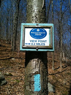
The Paugussett Trail is a 9.2-mile (14.8 km) Blue-Blazed hiking trail "system" in the lower Housatonic River valley in Fairfield County and, today, is entirely in Shelton and Monroe, Connecticut. Much of the trail is in Indian Well State Park and the Town of Monroe's Webb Mountain Park. The mainline trail is primarily southeast to northwest with three short side or spur trails.
The Aspetuck Valley Trail is a 5.9-mile (9.5 km) Blue-Blazed hiking trail in the Aspetuck River Valley area of Fairfield County in the towns of Newtown, Easton and Redding Connecticut.
Scantic River State Park is a public recreation area consisting of several separated parcels totaling 784 acres (317 ha) along the Scantic River in the towns of Enfield, East Windsor, and Somers, Connecticut. The state park is suitable for hiking, fishing, and hunting and is managed by the Connecticut Department of Energy and Environmental Protection.

The Aspetuck Land Trust is a nonprofit organization founded in 1967 that seeks to preserves open spaces in the towns of Westport, Fairfield, Weston and Easton in Fairfield County, Connecticut. In 2011 it was reported that the trust covered an area of 1,700 acres over 43 sites which include public trails.

Beaver Brook State Park is an undeveloped public recreation area covering 401 acres (162 ha) in the towns of Windham and Chaplin, Connecticut. The state park encompasses Bibbins Pond, also known as Beaver Brook Pond, as well as the acreage northward as far as the Air Line State Park Trail, which forms the park's northern boundary. The park is a walk-in facility, open for hunting and trout fishing, managed by the Connecticut Department of Energy and Environmental Protection.

Quaddick State Park is a public recreation area located on 203-acre (82 ha) Middle Quaddick Reservoir in the town of Thompson, Connecticut. The state park is managed by the Connecticut Department of Energy and Environmental Protection and offers opportunities for boating, swimming, fishing, and picnicking.

Becket Hill State Park Reserve is a public recreation area lying adjacent to Nehantic State Forest in the town of Lyme, Connecticut. The state park is as an undeveloped, walk-in park totaling 260 acres (110 ha) with no officially listed activities. It is managed by the Connecticut Department of Energy and Environmental Protection.

Centennial Watershed State Forest is a Connecticut state forest of more than 15,000 acres with larger parcels located in the towns of Easton, Newtown, Redding, and Weston. Dozens of other properties are strung throughout much of Southwestern part of the state. In 2002, the lands were acquired from the Aquarion Water Company by the state in partnership with The Nature Conservancy. Those three entities continue to manage the property by committee. The forest was named in honor of the hundredth anniversary of the state forest system.

Nassahegon State Forest is a Connecticut state forest occupying 1,227 acres (497 ha) in the town of Burlington.The forest is managed for forestry and recreational purposes and is operated by the Connecticut Department of Energy and Environmental Protection.

Nehantic State Forest is a publicly owned forest and recreation area occupying two parcels, one in the town of Lyme and one in the towns of East Lyme and Salem, in the state of Connecticut. The forest, which totals 5,062 acres (2,049 ha), is the site of regular prescribed burns and timber-harvesting operations. Purchase of the land began in 1926, when it became the first state forest located in New London County. It is managed by the Connecticut Department of Energy and Environmental Protection.