Tsemes Bay

Last updated
A panoramic view of the Tsemes Bay from the Markotkh Range. Nov Pan.jpg
A panoramic view of the Tsemes Bay from the Markotkh Range.

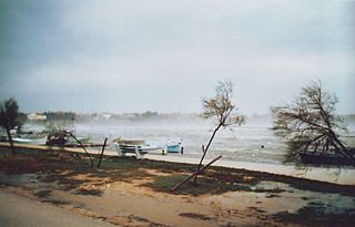
The Tsemes Bay (also Tsemess Bay and Novorossiysk Bay; Russian: Цемесская бухта, Tsemesskaya bukhta) is an ice-free bay located on the northern coast of the Black Sea, in Krasnodar Krai of Russia. It takes its name from the Tsemes River which flows into the bay. The depth of the sea varies from 21 to 27 meters. The length of the bay is 15 kilometers; its maximum width is 9 kilometers. It is bordered by the Sudzhuk Spit and Cape Doob.

Bay A recessed, coastal body of water connected to an ocean or lake

A bay is a recessed, coastal body of water that directly connects to a larger main body of water, such as an ocean, a lake, or another bay. A large bay is usually called a gulf, sea, sound, or bight. A cove is a type of smaller bay with a circular inlet and narrow entrance. A fjord is a particularly steep bay shaped by glacial activity.

Black Sea Marginal sea of the Atlantic Ocean between Europe and Asia

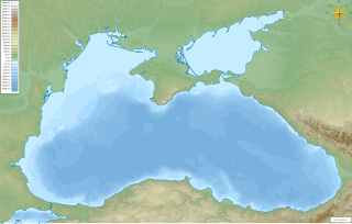
The Black Sea is a body of water and marginal sea of the Atlantic Ocean between the Balkans, Eastern Europe, the Caucasus, and Western Asia. It is supplied by a number of major rivers, such as the Danube, Dnieper, Southern Bug, Dniester, Don, and the Rioni. Many countries drain into the Black Sea, including Austria, Belarus, Bosnia and Herzegovina, Bulgaria, Croatia, Czech Republic, Georgia, Germany, Hungary, Moldova, Poland, Romania, Russia, Serbia, Slovakia, Slovenia, Turkey and Ukraine.

Krasnodar Krai First-level administrative division of Russia

Krasnodar Krai is a federal subject of Russia, located in the North Caucasus region in Southern Russia and administratively a part of the Southern Federal District. Its administrative center is the city of Krasnodar. The third most-populous federal subject, the krai had a population of 5,226,647 as of the 2010 Census.

Although the navigation is affected by strong autumn and winter bora winds (up to 220 kilometers per hour), the bay was frequented by ancient Greek navigators who established the colony of Bata on the shore. Michael Rostovtzeff explained this by the fact that there are no other decent harbours along the coastline all the way to Batumi. [1] During the Middle Ages, the coast was controlled by the Ghisolfi merchant family of Genoa.

Novorossiysk City in Krasnodar Krai, Russia

Novorossiysk is a city in Krasnodar Krai, Russia. It is the country's main port on the Black Sea and the leading Russian port for exporting grain. It is one of the few cities honored with the title of the Hero City. Population: 241,952 (2010 Census); 232,079 (2002 Census); 185,938 (1989 Census).

Michael Rostovtzeff Russian historian of ancient history

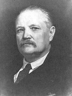
Mikhail Ivanovich Rostovtzeff, or Rostovtsev was a historian whose career straddled the 19th and 20th centuries and who produced important works on ancient Roman and Greek history. He was a member of the Russian Academy of Science.

Batumi Place in Adjara, Georgia

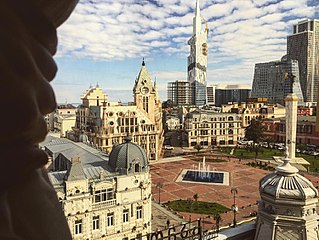
Batumi is the capital of Autonomous Republic of Adjara and the second-largest city of Georgia, located on the coast of the Black Sea in the country's southwest. It is situated in a Subtropical Zone at the foot of Caucasus. Much of Batumi's economy revolves around tourism and gambling, but the city is also an important sea port and includes industries like shipbuilding, food processing and light manufacturing. Since 2010, Batumi has been transformed by the construction of modern high-rise buildings, as well as the restoration of classical 19th-century edifices lining its historic Old Town.

Novorossiysk, founded by Russians as a military facility, is the chief port on the bay. Several ships of the Black Sea Fleet were scuttled in the bay to avoid their capture by the Germans in 1918. It was also the scene of several notable shipwrecks, including that of SS Admiral Nakhimov in 1986. Following the establishment of the Caspian Pipeline Consortium, the Commercial Seaport of Novorossiysk has emerged as the busiest oil terminal in the Black Sea. The southern portion of the bay, with the minor resort of Kabardinka, is administered from Gelendzhik (see Gelendzhik Bay).

Black Sea Fleet regional command of the Russian (and former Soviet) Navy

The Black Sea Fleet is the fleet of the Russian Navy in the Black Sea, the Sea of Azov and the Mediterranean Sea.

SS <i>Admiral Nakhimov</i> steamship launched in March 1925

SS Admiral Nakhimov, launched in March 1925 and originally named SS Berlin, was a passenger liner of the German Weimar Republic later converted to a hospital ship, then a Soviet passenger ship. On 31 August 1986, Admiral Nakhimov collided with the large bulk carrier Pyotr Vasev in the Tsemes Bay, near the port of Novorossiysk, Russian SFSR, and quickly sank. In total, 423 of the 1,234 people on board died.

The Caspian Pipeline Consortium is a consortium and a pipeline to transport Caspian oil from Tengiz field to the Novorossiysk-2 Marine Terminal on Russia's Black Sea coast. It is also a major export route for oil from the Kashagan and Karachaganak fields. As of 2009, the CPC pipeline is the only oil export pipeline in Russian territory not wholly owned by Transneft.

Related Research Articles

Bora (wind) wind

The bora is a northern to north-eastern katabatic wind in the Adriatic Sea. Similar nomenclature is used for north-eastern winds in other littoral areas of eastern Mediterranean and Black Sea basins.

Banya is a village in southeastern Bulgaria, situated in the Nesebar Municipality of the Burgas Province. It is situated at the foot of the Eastern part of the Balkan Mountains, 6 km from the Black Sea Coast.

Gelendzhik Town in Krasnodar Krai, Russia

Gelendzhik is a resort town in Krasnodar Krai, Russia, located on the Gelendzhik Bay of the Black Sea, between Novorossiysk and Tuapse. Greater Gelendzhik sprawls for 102 kilometers (63 mi) along the coastline and covers an area of 122,754 hectares, although only 1,926 hectares fall within the boundaries of Gelendzhik proper. Population: 54,980 (2010 Census); 50,012 (2002 Census); 47,711 (1989 Census).

Mădăras Commune in Bihor County, Romania

Mădăras is a commune in Bihor County, Romania, 3 km from Salonta, located nearby the Hungarian border - on the European road E671, and the Körös River canal. In 2011, it had 2,828 inhabitants. The commune Hungarian name means "fowler", the Romanian name derives from that as well. It is composed of four villages: Homorog (Oláhhomorog), Ianoșda (Jánosd), Marțihaz (Marciháza) and Mădăras.

Charax, Crimea Roman military settlement

Charax is the largest Roman military settlement excavated in the Crimea. It was sited on a four-hectare area at the western ridge of Ai-Todor, close to the modern tourist attraction of Swallow's Nest.

Sail Rock geographical object

Sail Rock, or Parus Rock, is a natural sandstone monolith of late Cretaceous age located on the shore of the Black Sea, in Krasnodar Krai, Russia. It resembles the outline of a ship's sail, hence its name.

Black Sea Governorate Place in Governorate, Russia

The Black Sea Governorate, also known as Chernomore or the Black Sea Government, was one of the guberniyas of the Caucasus Viceroyalty of the Russian Empire.

Arkhipo-Osipovka human settlement in Russia

Arkhipo-Osipovka is a rural locality and a Black Sea resort under the jurisdiction of the Town of Gelendzhik in Krasnodar Krai, Russia. Arkhipo-Osipovka is located 50 kilometers away from the city of Gelendzhik. This place has one of the softest climates on the Russian sea coast. Population: 7,853 (2010 Census); 8,066 (2002 Census); 7,242 (1989 Census).

A147 highway (Russia) road in Russia

The Russian route A147 is a Russian federal highway, a mountain highway that runs along the coast of the Black Sea in Krasnodar Krai from Novorossiysk through Gelendzhik, Tuapse, and Greater Sochi to Adler. The road terminates at Russia's border with Abkhazia/Georgia.

North Caucasus Railway

North Caucasus Railway is a 1,520 mm broad gauge Russian railway network that links the Sea of Azov and Caspian Sea. It runs through ten federal subjects: Rostov Oblast, Krasnodar Krai, Stavropol Krai, Republic of Adygeya, Karachay–Cherkessia, North Ossetia, Ingushetia, Chechnya, Dagestan, and Kalmykia. The headquarters are in Rostov-on-Don.

Nowa Wioska, Krosno Odrzańskie County Village in Lubusz, Poland

Nowa Wioska is a village in the administrative district of Gmina Gubin, within Krosno Odrzańskie County, Lubusz Voivodeship, in western Poland, close to the German border. It lies approximately 14 kilometres (9 mi) south of Gubin, 37 km (23 mi) south-west of Krosno Odrzańskie, and 58 km (36 mi) west of Zielona Góra.

Markotkh Range mountains in Russia

The Markotkh is a low 90 km-long mountain range in the extreme northwest of the Greater Caucasus that, running parallel to the Black Sea coastline, encircles the Tsemes Bay and the Gelendzhik Bay.

Gelendzhik Bay

The Gelendzhik Bay is an ice-free bay located on the Russian coast of the Black Sea, immediately to the southeast of the Tsemes Bay. The entire 12-km coastline between the capes Tonkiy and Tolstyi falls within the boundaries of Gelendzhik. Beaches take up about two thirds of shoreline. Further inland rise the low Markotkh mountains. The maximum depth of the sea is 11 meters.

2012 Krasnodar Krai floods flood event that took place in Krasnodar Krai in Russia

The 2012 Krasnodar Krai floods occurred in southwest Russia in early July, mainly in Krasnodar Krai near the coast of the Black Sea. The equivalent of five months of rain fell overnight in some southern parts of the country according to the Hydrometeorological Centre of Russia. One hundred seventy-one people died during the floods, and Russian police said the floods damaged the homes of nearly 13,000 people. According to the governor of Krasnodar Krai, Aleksandr Tkachyov, "there was nothing of the kind for the last 70 years". The flood was part of the aftermath of an intense storm that hit Krasnodar, dropping almost half a year’s worth of rainfall on the region over two days. Close to 30,000 people were affected by the floods.

A290 highway (Russia) road in Russia

The A290, before 2018 also known as M25, is a federal road in Russia that runs east-west along the northeast shore of the Black Sea from Novorossiysk to Port Kavkaz, and, via the Crimean Bridge, to Kerch in Republic of Crimea.

Port of Novorossiysk port in Russia

Novorossiysk Sea Port is one of the largest ports in Russia, located on the Black Sea. The seaport is located on the north-east coast in the ice and is convenient for navigation in Tsemes Bay. The port is navigable all year round. Novorossiysk Bay is available for vessels with a draft up to 19.0 m and the inner port waters - up to 12.5 m. The port is operated by the Novorossiysk Commercial Sea Port. The port is also a major naval base of the Black Sea Fleet of the Russian Navy.

Soviet cruiser <i>Mikhail Kutuzov</i> 1954 Project 68bis cruiser of the Soviet Navy

Mikhail Kutuzov was a light cruiser project no. 68-bis of the Soviet and later the Russian Navy's Black Sea Fleet.

References

  1. Rostovtzeff, Michael Ivanovich. Iranians and Greeks in South Russia. The Clarendon Press, 1922. Page 63.

Coordinates: 44°41′00″N37°50′00″E / 44.6833°N 37.8333°E / 44.6833; 37.8333

Geographic coordinate system Coordinate system

A geographic coordinate system is a coordinate system that enables every location on Earth to be specified by a set of numbers, letters or symbols. The coordinates are often chosen such that one of the numbers represents a vertical position and two or three of the numbers represent a horizontal position; alternatively, a geographic position may be expressed in a combined three-dimensional Cartesian vector. A common choice of coordinates is latitude, longitude and elevation. To specify a location on a plane requires a map projection.