Related Research Articles

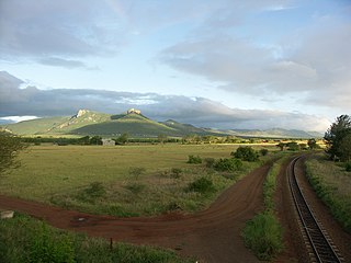
Eswatini, officially the Kingdom of Eswatini and also known as Swaziland, is a landlocked country in Southern Africa. It is bordered by Mozambique to its northeast and South Africa to its north, west, and south. At no more than 200 kilometres (120 mi) north to south and 130 kilometres (81 mi) east to west, Eswatini is one of the smallest countries in Africa; despite this, its climate and topography are diverse, ranging from a cool and mountainous highveld to a hot and dry lowveld.

Eswatini is a country in Southern Africa, lying between Mozambique and South Africa. The country is located at the geographic coordinates 26°30′S31°30′E. Eswatini has an area of 17,363 square kilometres, of which 160 are water. The major regions of the country are Lowveld, Midveld and Highveld.
The economy of Eswatini is fairly diversified. Agriculture, forestry and mining account for about 13 percent of Eswatini's GDP whereas manufacturing represent 37 percent of GDP. Services – with government services in the lead – constitute the other 50 percent of GDP.
Public transport is the main means of transportation in Eswatini. Car ownership is low, at 32 cars per 1,000 people. The National Road Network has 1500 km of main roads and 2270 km of district roads.
The Umbutfo Eswatini Defence Force (UEDF) is the official armed national military of the Southern African Kingdom of Eswatini. is used primarily during domestic protests, with some border and customs duties; the force has never been involved in a foreign conflict. The army has struggled with high rates of HIV infection. Since measures were put in place the rate is dropping.
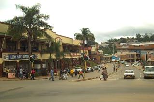
Mbabane is the capital and largest city in Eswatini. With an estimated population of 94,874 (2010), it is located on the Mbabane River and its tributary the Polinjane River in the Mdzimba Mountains. It is located in the Hhohho Region, of which it is also the capital. The average elevation of the city is 1243 meters. It lies on the MR3 road.
The Eswatini national football team, nicknamed Sihlangu Semnikati, represents Eswatini, formerly known as Swaziland, in international football and is controlled by the Eswatini Football Association. It has never qualified for the World Cup or the Africa Cup of Nations finals. Swaziland's best performance in an international tournament is a semi-final finish in the COSAFA Cup.
Mkuze, also named Mkhuze or uMkhuze is a small town in Northern KwaZulu-Natal, South Africa. It is located approximately 350 km from the city of Durban. It is along the N2 road en route to Johannesburg, Eswatini and Mozambique; between the Mkuze River and Intaba Yemikhovu. Mkuze is some distance from other small towns such as Hluhluwe (50 km), Nongoma (76 km), Pongola (65 km), and Jozini (25 km). Mkuze is the seat of Umkhanyakude District Municipality.

Lobamba is the traditional, spiritual, and legislative capital city of Eswatini, seat of the Parliament, and residence of the Ntombi, the Queen Mother. Mswati III lives about 10 kilometres (6.2 mi) away at the Lozitha Palace. The King and Queen Mother participate in annual December and January Incwala ceremonies and August and September Reed Dancees at the Royal Kraal.
Articles related to Eswatini include:
Simunye is a sugar mill town on the lowveld in eastern Eswatini. Almost all of the residents of the town work for the Royal Swaziland Sugar Corporation's sugar mill located nearby.
The following outline is provided as an overview of and topical guide to Eswatini:
Education in Eswatini includes pre-school, primary, secondary and high schools, for general education and training (GET), and universities and colleges at tertiary level.

Hlane Royal National Park is a national park in Eswatini, roughly 67 km northeast of Manzini along the MR3 road. Prior to the park being public, it was a private royal hunting ground. Hlane, meaning 'wilderness', was named by King Sobhuza II. It is now held in trust for the Nation by His Majesty King Mswati III, and is managed by Big Game Parks, a privately owned body.

Malolotja National Park covers 18,000 hectares of mountain wilderness on Eswatini's northwestern border with South Africa. The park includes Ngwenya Mountain, Eswatini's second highest mountain, and Malolotja Falls which drop 89 metres (292 ft), the highest in Eswatini. Habitats include short grassland to thick riverine scrub, bushveld and Afromontane forest.
Gege is a town in the Shiselweni district of southern Eswatini.

The MR3 road, also known as the Matsapha–Mbabane–Ngwenya road or Road No. MR3, is a major highway of Eswatini. It is one of the most heavily trafficked roads in the country, crossing it from east to west. Along with the MR7 and MR8 roads, it forms the "backbone of Swaziland's internal transport system." It connects the EN5 road in Mozambique near Namaacha at 25°59′21″S31°59′53″E to the N17 road in South Africa at 26°12′45″S30°59′18″E, near Ngwenya. The road passes through Hlane Royal National Park and through the capital of Mbabane, about 110 kilometres (68 mi) further to the southwest. The highway descends into the Ezulwini Valley in four lanes. At Manzini, a bridge crosses the Mzimene River.

Lubombo is a region of Eswatini, located in the east of the country. It has an area of 5,849.11 km² and a population of 212,531 (2017). Its administrative center is Siteki. It borders all three other regions: Hhohho to the north, Manzini to the west, and Shiselweni to the south. It is divided into 11 tinkhundla.
Matata is a town in Eswatini.
References
- ↑ Southern Africa Road Atlas . Lonely Planet. pp. 71. ISBN 1-86450-101-4.
- ↑ "About E2 billion pumped into LUSIP, Komati projects" . Retrieved 2010-11-02.
- ↑ "Swaziland Tourism Authority Photo Catalogue" . Retrieved 2010-11-02.
Coordinates: 25°59′S31°43′E / 25.983°S 31.717°E
| This Eswatini location article is a stub. You can help Wikipedia by expanding it. |